Good Sunday, folks. We have a big blast of September air on the way to the bluegrass state for the week ahead. This may cause the thoughts of pumpkin spice lattes to dance in your head, so it seems like a good time to take a “way too early” look ahead to fall and winter.
Before we do that, let’s get caught up on the week ahead of us.
We have to watch for isolated showers and storms going up out there today as moisture increases ahead of a strong, fall cold front. This barrels into town on Monday with some showers and storms…
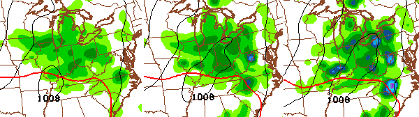
Some of the storms could be on the strong side. Winds will really gust up as the front moves through here. By Tuesday, temps have dropped into the upper 70s to around 80 for highs. We should see similar highs for the rest of the week with lows in the 50s. Mainly dry weather is likely during this time, but we will have to watch for an instability shower.
This much cooler than normal week follows a cooler than normal first week of August. Check out this map from the folks at WeatherBell…
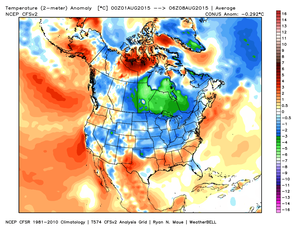
This upcoming week could mean August winds up below normal across Kentucky and that could skew the summer slightly cooler than normal. It’s been another bad summer for our local drought and heat mongers.
Does this mean summer is finished? Nope. As a matter of fact, I’m already on record in saying I expect a pretty toasty spell to develop in September.
With the kiddos going back to school, this is the time of year I start really getting bombarded with questions about the upcoming winter. If you’re a regular reader, you know I’ve been talking about how intrigued I am by the developing strong El Nino. The timing, magnitude and placement of it have no true matches in my view. That’s what makes this fun to track.
In addition to the developing El Nino, we have an amazing pool of very warm water off the west coast and into the Gulf Of Alaska…
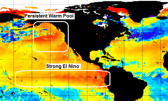
That bad boy developed late in the summer of 2013 and has been there ever since. That, to me, has been the absolute driver of the weather across the country and is the reason we’ve had very little change in our overall pattern since then. It helps drive a big ridge along the west coast and allows for the jet stream to take a dip across the eastern part of the country.
Think about it… wet summers with not much hot weather and back to back incredibly harsh winters. That pool is forecast to remain there into the upcoming winter. But, what happens when we throw in the strong El Nino? That’s the million dollar question and that’s what fascinates me.
This strong El Nino is becoming a basin-wide event with the warmest waters relative to normal slowly shifting west away from South America. If you like winter weather, that’s, at least, a positive sign. When the warmest waters are near the South American coast, that means blowtorch city for winter temps around here. That’s what happened during the last big el nino of 1997. Again, the warmest anomalies will likely be much farther west than that El Nino.
So what does all this mean for the upcoming winter? It’s simply too early to tell, but a progression similar to last winter is on the table. I’m not talking about an actual repeat… Just how it progressed with a big winter taste early then a break and then boom.
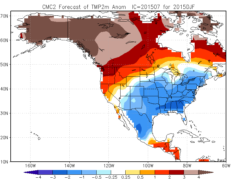
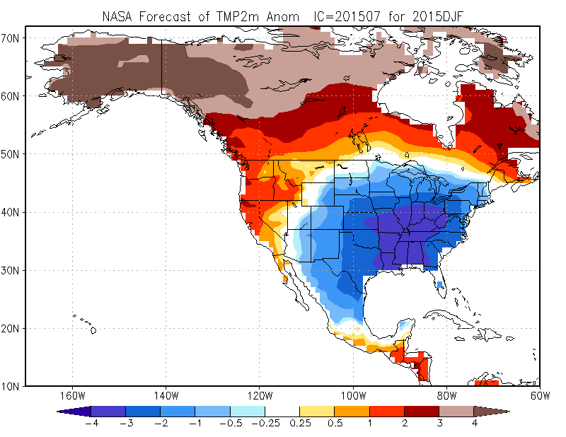
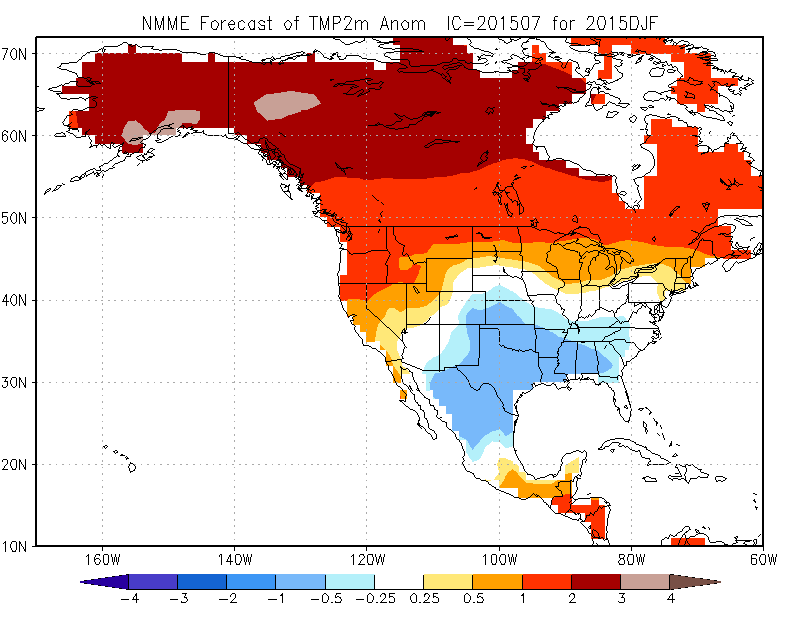
This is also the time of year I start looking at the seasonal forecast models to see how they are handling things. Here’s a sampling for the December-February periods…
Canadian SIPS
NASA
NMME
SST Constructed Analog only covers November- January:
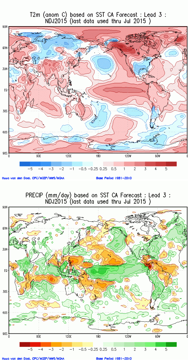
That’s a pretty crazy consensus showing up on a series of different seasonal models. Of course, it’s very, very early in the game, so keep that in mind.
Was this post worth the wait? 🙂
Make it a great day and take care.

If I’m reading these maps right, the “frigid” looking blues are only 1 to 3 degrees cooler than the average August temps. Big whoop. Northern Florida and South Texas are also blue according to the map. Can some weather guru tell me if I m right or wrong?
Thank you for being one of the few people to apparently read the legends on the maps for themselves (when they’re available) and not just read the posts. Gold internet star for you! As to the “cooler” summer, it’s gets more interesting when you look the how much higher than avg. the LOW temps were each day and not just what the high temps were versus the avg.
However, I do think the weather change will be substantial because of the much dryer air coming in, that’s where you’ll be feeling the difference and why the change is hype worthy in the end.
You’re forgetting that’s in Celsius.
Chris – great post! I enjoyed reading it.
It’s interesting that you can’t find any similarities with past strong El Nino’s. It will be fun to see what will happen….
I’m a long time every day blog reader, and I feel pretty confident in my weather knowledge, but this post left me a bit confused!! Haha!! So, just looking at the winter “way to early” we are expecting cooler than normal with a quick start, break in the middle and then BOOM?? 🙂 Similar pattern as last winter, correct? That would make my kids really happy! haha!! 🙂
Definitely worth the wait CB! This winter is going to be another exciting one to track!
Meanwhile, a heat index level of 165. freakin’ 90 dew point!!
http://www.washingtonpost.com/blogs/capital-weather-gang/wp/2015/07/30/iran-city-hits-suffocating-heat-index-of-154-degrees-near-world-record/?tid=sm_fb
I do not pay attention to these maps. I’ll believe it when I see it. That said, I shall enjoy the rest of summer and the fall before worrying about winter fun. All seasons are appreciated.
When the maps are in Celsius it always throws my wife off. She always relates to Fahrenheit and does not think about the fact that 1 degree Celsius is not equal to 1 degree Fahrenheit although she knows this. The Fahrenheit average was 42 but the Celsius average was about 5.6. Take 5 degrees off that Celsius average and you have 0.6 which is about 33 degrees Fahrenheit. Which is a 9 degree departure from average.
Great first look. Hope we can have a very fun winter. I am ready. My youngest is 2 and will have a blast this year. So snow is very welcome. The rain has kept him in a lot this summer but the snow will have the opposite effect.
Thank you Chris!
Yes, this was well worth waiting for.. thank you!
As an aside, we have research shows that El Niño activity correlates with Little Ice Ages and given that this El Niño is without precedent in modern times.. and solar activity is at the lowest level for 200 years, well.. I will lead you to draw your own conclusions 🙂
Having had two harsh winters back-to-back, I’m not ashamed to say that I’m hoping for some blowtorches this coming winter.
First, thanks for all you do CB; you are a great short-term and long-term weather forecaster. I know that it is way too early to lock-in and hold any meteorologist accountable for long range forecasts up to 6 months out; however, I think this El Nino spells big trouble for KY if the northern branch remains active…watch out and stay tuned…
Plus, it is unusual for so many different models to predict similar to nearly identical long-range forecasts for temperature and precip…look out!
Thanks for the early preview from the many different models!