Good Monday and Happy Labor Day. Many of you are enjoying a three day weekend, but for your friendly weatherdude, it’s just another manic Monday. With cookouts and picnics being all the rage of the day, I’ve decided to put together one heck of a weather menu for this update.
We will fire up the grill for some shot-range stuff to start whet your appetites. After that, let’s move on to a nice helping of fall chill on the way by this weekend. To top off our weather cookout, how about a cold one? Of course, I’m talking about winter and a look at some of the new seasonal forecast models.
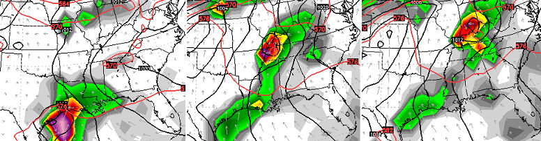
Hot off the grill is the weather we have out there today and into Tuesday. This is pretty much a continuation of the obnoxious temps we’ve had much of the holiday weekend. Watch for scattered storms.
The storm threat increase later Tuesday night into Wednesday as a cold front moves in. This front will slow down as low pressure develops along it. This should bring some needed rains to the region.
MUCH cooler air then swings in here by the end of the week into the weekend. Our temps go well below normal for much of this time. Highs may struggle to get into the low and middle 70s for some on a day or two…

Lows in the 40s are a good possibility for many…

It’s once into next week that we find the models going back into flip and flop mode. The latest European Model offers up a tropical system from the Gulf of Mexico…
After how the models handled Erika, I would take that with a gain of salt. I will say one thing… the pattern across North America looks like it wants to get pretty darn active in the coming weeks!
I’ve made no secret on how intriguing this big daddy El Nino is to me. I’ve harped on what I thought would happen with it since the spring and I still can’t find any true analog for it.
The warmest Pacific waters continue to slowly spread west along the equator and away from South America. That’s a trend that should continue over the next several months. This shows up well with the NASA model forecast for the upcoming winter…

I’ve highlighted the warmest anomalies in the white box. You can clearly see how the warmest water relative to normal is well to the west of South America. The black box features the huge warm pool of water off the west coast of North America and into the Gulf of Alaska. That’s been there since the fall of 2013 and has, in my view, been the biggest driver of the weather across the United States. That warm pool promotes ridging up along the west coast and into Alaska and Canada. In turn, we get troughs to develop across the eastern US.
Some are trying to compare this El Nino to the El Nino of 1997. That too was a monster, but that’s where the similarities end for me. Here’s a look at the ocean temp anomalies from late December of 97…
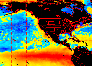
You can see how much farther east the warmest water was along the equator. Not only that… look at the water off the west coast and into the Gulf of Alaska. Not even close to what the seasonal models are forecasting for this winter.
Now, we have to point out that the 1997 map is reality while the map above it is only a forecast for the same time period.
So what does the NASA model say for temps? It shows a winter that’s overall cold, but really grows colder the deeper we get into it…
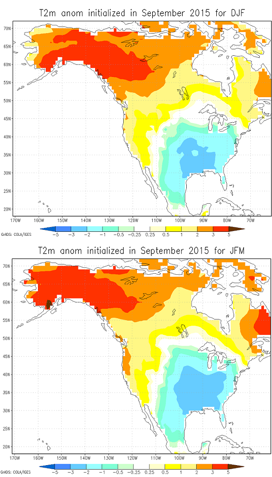
The first map is for December-February with the map below it showing January-March.
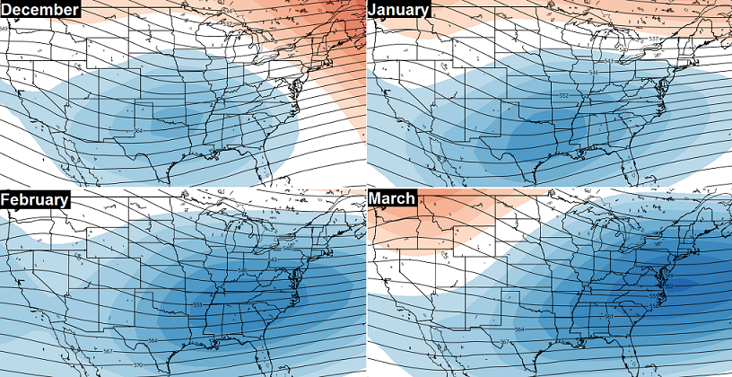
If we look at the new Canadian Sips model, we find a similar progression through the winter with a mean trough in the east and southeast…
Thanks for dropping by my little backyard weather cookout and have a safe trip home.
Happy Labor Day and take care.

Might fine weather cookout best one I had to date.
I really dread this winter, extreme seems to be the word the weather has taken, thanks for all you do Chris!
I find the weather cookout to be a good one. One thing that really sticks out to me is the mention of some ” much needed” rain. After being waterlogged for the better part of the spring and early summer, it’s getting pretty dry.
Chris when you give your thoughts on the upcoming winter, I’d trust your ‘hunches’ or feelings more than anyone I know. Right now, I’m going to enjoy this day off and have some fun. Have a safe and Hapoy Labir Day everyone. Thanks Chris got all you do. Enjoyed the cookout, now where’s dessert?
Thanks for the informative post today. Answered some lingering questions I’ve had for this coming winter.
Have an awesome day!
I know it is still early, but I totally agree with Chris’s thinking. Not only are the signs from Mother Nature lining up with a bad winter, we are certainly in the same blocking pattern we have been in for two years now, despite the past couple of weeks of above average temps. Watch out if we have both active northern and southern jet stream branches this winter as this will be the first time I have ever witnessed a weather pattern quite like this before!!!!!
Good one Chris! Thanks for the winter outlook! Happy Labor Day to all!
Just read the ole farmers and farmers almanac winter forecast both of them has a cold and snowy winter for our region. The forecast is the same what Chris is saying.
I’m done with big snow. The two big ones we got in March made me realize I recalled the good, but not the bad things about the big snows.
I would say Jackson NWS office needs a little more help than just London in the hourly weather roundup. The rest of the locations in their CWA are not under NWS quality control. Gives you a lot of confidence in the data they use, now don’t it?
People will laugh at me…not the 1st. time…haha! 🙂
I live in Bardstown. (And no, I do not imbibe the Bourbon…eww!), but tonight right after the brats & Italian sausage, corn on the cob, and peppers/onions hit the table, it was POURING rain (w/FULL SUN!) in the backyard. I had actually, not even 2 sec’s prior, came in from the FRONT yard??! No kidding….NOTHING in the front, but pouring in the backyard……??! (And to think I made fun of my Ex who once said he was pouring concrete in one driveway under sun, and the next driveway about 50 ft away was getting drenched….?!)
Watched this guy in while in houston. He reminded me of you and your weather telling style.
http://m.click2houston.com/justin-stapleton/30704178
Looking foward to some ky weather.. sounds intetesting when i get back home mid week.
Thanks chris
GREAT analysis of the upcoming winter, Chris! I trust you over most anyone on long- and short-term weather forecasts.. even though I am in WV, you are still my number one “go-to”, and have been since 2011 🙂
Thank You!