Good Tuesday, everyone. We’re on the last day of our late Summer heat wave across our part of the world.Big changes are just around the corner and that means an increase in rain chances and a decrease in thermometers. As a matter of fact, some decent rains could be in store as temps go well below normal.
Showers and storms will really increase Wednesday into Thursday. A few of the storms could even be on the strong side just ahead of a cold front moving our way.Temps come way down compared to today.
All of this is ahead of a developing deep trough across the eastern part of the country. Watch how quickly this thing goes bonkers on the European Model…
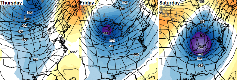 That should allow for a secondary low pressure to develop just to our south and then swing inland up the east coast. Some very cool rain would be possible in this kind of a scenario…
 That same setup from November through the winter would bring accumulating snows to this region. Of course, it’s September so we only have to watch for cool rains. Check out the highs from the same run of the European Model…
 That’s some impressive stuff, but we only get that cool if the low develops like the model is showing. If not, you will have to settle for low and mid 70s. 🙂
Either way… lows should be able to reach the 40s on a morning or two later in the weekend and early next week.
Obviously, things have dried out and we need some rain across Kentucky. In true bluegrass state fashion, the European Model shows us going from one extreme to another over the next 5 days…
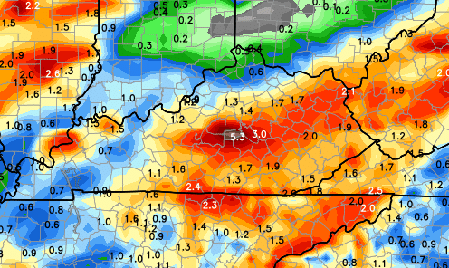 I would think some of that is overdone, but most areas should get some decent rains through the weekend.
Make it a great Tuesday and take care.

I know everyone hates the drought mongers on this page, but we really could use some rain in Harlan Co. I was over an inch down for August monthly rainfall and now, I haven’t seen an inch of rain since August 11th at my house, although some areas in the county have!
After today or tomorrow I’m wondering and thinking that temps in the 90’s will be a distant memory.
You know it’s funny some east coast schools let out early today because of the excessive heat. Gotta laugh, schools around here do not get dismissed early for temperatures in the mid to upper 90’s. On the flip side of the coin schools around the Commonwealth will let out early for a pending snow or a couple of inches where the east coast laughs at us. It’s all about the region where you live.
This ties for the 3rd longest streak of consecutive 90 degree days in Lexington. Only longer streaks were in 1897 and 1936. Looks like the streak will end at 8. Still impressive!