Good Wednesday, everyone. Big time changes are blowing into the bluegrass state over the next few days as a couple of cold front swing in here. This means we get in on some much needed rains before our temps take a big plunge.
As a matter of fact, I’m issuing a Pot Of Chili ALERT for the weekend…
 I will get to the details on that in a moment. First, let’s talk about how we get there.
Showers and storms increase throughout the day as a cold front nears from the west. Locally heavy rains and a strong storm or two will be possible. Those showers and storms will carry us into early Thursday before we try to dry it our later in the day.
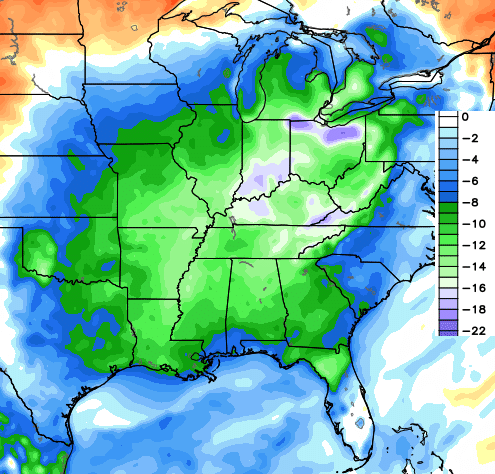
That dry period won’t last long as showers and storms quickly return on Friday ahead of the next system. This is a MUCH stronger dip in the jet stream. Check this out…
 That’s absolutely nuts to see this time of year and can keep showers around into, at least, part of the weekend. That’s also some very chilly air showing up underneath such a deep system…
 Highs with a setup like that may not get out of the 60s for Saturday and Sunday…
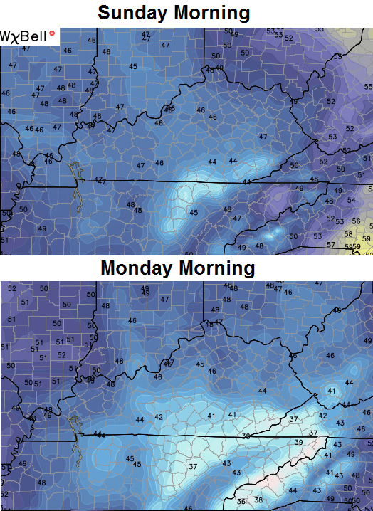
 Lows by Sunday and Monday could really tank…
I can smell the chili already!! 😉
I leave you with your Wednesday storm trackers…


Make it a great day and take care.

I like my high temps not getting out of the 50’s before I do chili. Of course, I have lots of habanero peppers from the garden this year…so, the cooler, the better.
Love it:)
First “Pot of Chili Alert” of the season! YESSS!
Chili is good no matter the time of year.
At Last! Relief is on the way! Chili in the hills!
I will have some cooler weather and a nice pot of chili to go.
I agree!
Starting Tuesday of next week will be right back in the low possibly mid 80’s. Nonetheless Fall is going to give us a nice glancing blow for the next few days.
Don’t mind a little cooling off as long as we get the needed rain! We go from one extreme to the other it seems like. Anyway, as long as it stays good in Florida and no tropical stuff at least until after Oct 10th. Of course, I don’t wish tropical damage on anyone at any time. Thanks Chris, for the update. As usual, you and WKYT rules weather!
I haven’t been able to get First Alert Defender to load the last month or so. Anybody else have this problem, or is it my computer?
Maybe its my link. Can someone post a link to it?
Lol I can’t go thru winter without the Defender 😉
Yeah that would be bad..since it’s suppose to be a very snowy one!
Good thing I like chili! Thanks for the weather report!
I hope that wasn’t all the rain, but it sure looks so. We had less than a 10 minute shower in my part of the world today. The cool air is welcome.
I feel your pain: I am the only area in the state (Harlan Co.) that does not even have a surplus for the year. I had a very wet July, but missed the rain in both June and August. Actually, part of the county is down 2 inches for the year, if you can imagine that:(
I have noticed all spring and summer that the SAME areas in Kentucky seem to get the heavy amounts of rain while the other areas in between get the lighter amounts. Topography plays a significant role in causing some areas to be left out like where I live:(
Didn’t much rain here in far western ky. Had a down pour just enough to wet everything.
I haven’t seen you on here much lately. It looks more and more like we might have an ole school winter. I asked my mom and some other people about the winter results of ’77’ in Harlan and they said they remember the town received about 80 inches for the season, which we have not had since. Also, the 80 inches was in the valley with much, much more on the higher elevations!!! I haven’t been able to confirm this as factual data; however, I did find some library data pertaining to the great flood in April of ’77’. My mom said all of the snow and ice from winter through March melted at the end of the month and 7 inches of rain fell ( I confirmed that through the local archived newspaper). It looks more and more like we are going to have a severe winter. What are you hearing out in Western KY!
Terry the winter outlook here is cold and snowy. But time will tell. That 77 winter was brutle very well remember it.