Good Sunday to one and all. October temps continue here in the middle of September and that’s giving us fall lovers a little slice of weather heaven. Temps continue to run cooler than normal into the start of the new week, but warmer changes are just around the corner.
Temps for many today will be back in the 60s unless you live at an airport. Some of our “official” thermometers are about as bad now as I’ve ever seen them. Thanks to the Kentucky Mesonet for giving us much more accurate readings. Here’s hoping they can secure enough funding to keep going for years to come.
Lows by Monday morning will drop deep into the 40s in many areas. A couple of high 30s will be possible in the coldest of valleys in the east. Sunny skies will boost afternoon highs into the low 70s central and east with mid 70s west.
Temps from there continue to climb through the week. Warm afternoons will cool mornings look to be the rule with mainly dry weather through Thursday.
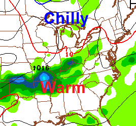
Showers and storms will try to increase on Friday as a cold front moves toward the region from the northwest. That front may slow down allowing for rain chances into the weekend…
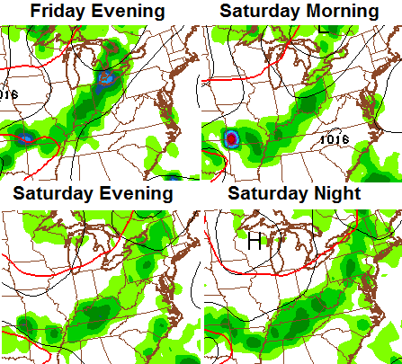
The models hang that boundary around into early the following week with a wave of low pressure trying to zip across the region from the west…
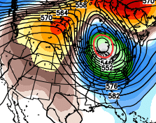
 Looking a little farther down the road, the GFS Ensembles are hinting at another hit and run deep trough in the east sometime late that same week…
I really think what we’re seeing is what we see through September into early October… A warmer overall pattern with potent, short lived, cold blasts mixed in. That’s also a pattern that can give us an active fall severe weather season. If you recall, each of the past two years gave us a memorable fall severe weather event.
Make it a sensational Sunday and take care.

Don’t brag about all Mesonet sites here in Kentucky. I have issues with a handful of them, namely Christian County, Campbell County, Warren County (take your pick…they have two), even nearby Clark County. But, I do agree our NWS offices should be better than that.
Interesting…Lex BG Air at 7:54a.m. 49 degrees / 93% hum
Mesonet site Fayette County 8:00 a.m. 49 degrees / 95% hum
Not too bad right now but differences become apparent later today.
Thanks Chris. Been a beautiful Sunday. Perfect prelude to fall. Not quite ready for it yet but I don’t think that it matters. ;). Have a beautiful rest of your Sunday all.