Good Monday, everyone. We’re coming off one of the colder weekends you will ever find for the middle of September. Naturally, temps can only turn warmer and that’s exactly what we have in store for the week ahead. That said, I’m already tracking changes for the weekend and into next week.
Today’s weather is the textbook definition of perfection. Near record lows will start the day with a few upper 30s and low 40s. Sunny skies and low humidity levels will make afternoon highs in the low 70s feel that much better.
Readings will warm into the upper 70s to around 80 in the central and east Tuesday with low 80s in the far west. The numbers will continue to rise for the rest of the week with warm afternoons and pleasantly cool mornings.
A cold front approaches the region from the northwest later Friday into Saturday. That front will have, at least, scattered showers and thunderstorms along it…
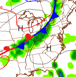
That front is likely to become stationary somewhere across the Ohio Valley through next weekend into early next week. If that happens, rounds of showers and thunderstorms could put down decent rains across the region…
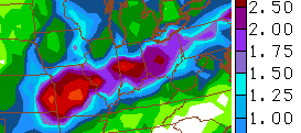 We will have to see exactly where that front checks up before we can pinpoint how much wet weather sets up shop around here.
The pattern should then try to spit out another, hit and run, deep trough in the east late next week…

As always, we shall see.
Have a great start to the week and take care.

Thanks CB and go Cats!!!!!!!
Almost forgot how much I love this time of year. Just doesn’t get much better than this in my book.
Today was perfection in Richmond.
Amen Jason