Good Sunday, everyone. Cooler air continues to blow into the bluegrass state today and this should set the stage for a pleasant temperature week ahead. Overall, the pattern is a little more active than what we’ve been seeing, but there’s still not much to write home about.
Highs today will general range from 70-75 for many areas with a mix of sun and clouds. Clouds will be more prominent across the east and southeast and we could even see a shower or two in these areas. Temps could be a little cooler in those areas.
A better chance for a shower or two will be with us on Monday as a wave of low pressure winds up just to our east…
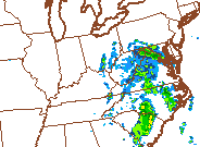 The deeper moisture stays east of the Appalachian Mountains, but a few showers will likely sneak into the eastern half of the state. Temps will range from near 70 in the east to the mid 70s in the west.
That sets the stage for a blocky looking pattern along the east coast. High pressure near New England will keep a big area of low pressure trapped just east the Mid Atlantic states…

That means our predominant wind flow should be from the northeast. Normal to below normal temps with a small chance for a shower or storm. If that low can back farther west in time, the rain chances would increase.
Looking farther down the roan, a familiar pattern is trying to return on some of the medium range models…
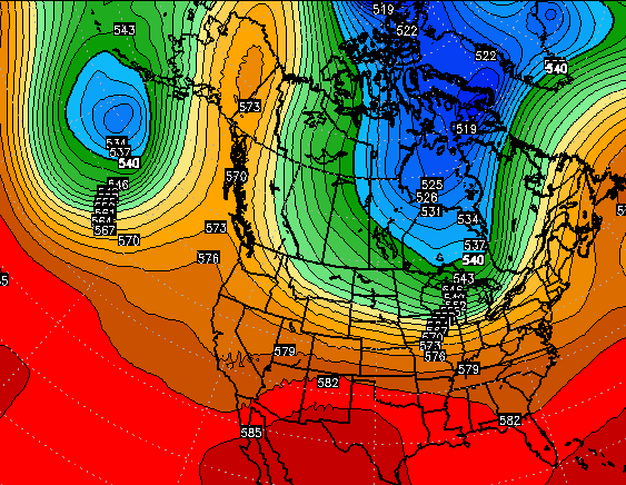
A blocking ridge up the west coast into Alaska with a trough around the Aleutian Islands, allows for a deep trough to develop from Canada into the United States. That’s similar to what we’ve seen for much of the past 2 falls and winters.
I’ve talked and talked and talked about how crazy stable the pattern has been since the fall of 2013. Will that continue into this fall and winter? Time will tell.
I leave you with radars to track any shower that goes up today.


Have a great Sunday and take care.

It is dry here in Louisville….Since August 20, officially 0.84″. My house in Valley Station just to the west-southwest at 1.03″.
Bowling Green even worse….0.76″ since August 20.
According to latest drought monitor, ‘abnormally dry’ still for half of the state, improvement over last week. However, I believe the intensity of the dryness in some areas is increasing. Look for short term moderate drought conditions possibly in the next report this upcoming Thursday or the following Thursday, especially if these areas do not get any appreciable rainfall by then.
I was down over inch for the month of August and am currently down over 2 inches for September in Harlan Co. Like I have said before, the same areas in KY keep getting the rain while the same areas seem to miss it; this has been the same case since spring…strange this year. I have seem systems bring more rain to others and miss some places over the years, but it seems like we have really been stuck in a pattern where every weather system favors more rain in the same parts of the state while missing or barely hitting the other, drier areas.
It doesn’t look like any appreciable rain for the next 7 to 8 days. Cut off low looks to stay far enough away that most area’s will not be affected. Looks dry, cool nights and seasonal warm days.
The really good aspect of it being dry, which I don’t usually like, is that a beautiful leaf display may result. A lot of blue sunny days and cool nights coupled with little rainfall a few weeks before the normal leaf peak is a very good thing for helping the chlorophyll to break down. I hope we can get appreciable rain after the leaves begin to fall though or it will be a bad fire season after all of the early summer rain and extra resulting vegetation around the region!
Thanks Chris. We could use some rain here as well. It sprinkled last evening, but really didn’t even get the ground wet. I know September tends to be a dry month for us and it has certainly lived up to its reputation for sure. This has indeed been an odd weather year. Way too wet in the spring and now getting really dry. Makes me wonder about the upcoming winter. Have a great Sunday everyone.
Fall officially begins in three days.yes its dry here in western ky also. All that may change as el nino gets stronger late fall as they are saying.
The only real positive to the dry weather right now is the breakdown of the chlorophyll in the leaves. Hopefully, we will have a spectacular fall. When it rains a lot during September/October as happened last year, the chlorophyll cannot breakdown as well resulting in dull, washout colors. As of right now, I think we will have a very vibrant leaf display unless it starts to rain a lot during the next couple of weeks. I hope it does start rain before the leaves fall though, or we will be burning down, especially here in the mountains.
Hey Chris, are the long-range models giving any indication as to how the battle between El Nino and the Alaskan blob is expected to play out come Dec/Jan/Feb?