Good Monday to one and all. We have a lot of pleasant temperatures on the way to the bluegrass state this week. Things are pretty quiet, but the overall pattern is fairly active. Wait… What? We have a pretty interesting setup over the next week and change across the eastern part of the country.
Let’s start with today because a shower or two will be possible across the east and southeast. Much of the region should remain on the dry side with a mix of sun and clouds and highs in the 70s.


I made a map over the weekend illustrating the setup for the week ahead. That map showed a HUGE area of high pressure across the northeast with a SLOW moving area of low pressure off the southeastern seaboard. The models look a lot like my map…

That gives us a VERY strong east to northeasterly flow around here and that means some awesome temps. Near normal to, perhaps, slightly below normal should rule through the week and into the coming weekend. Can we get some rain out of that setup?
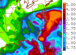
The models try to slowly back that low westward as it diminishes and gives way to a system in the Gulf. Several model runs do back some showers in here from the east later this week into the weekend. The GFS 7-day rainfall numbers…
That’s a setup we will have to keep a close eye on in the coming days.
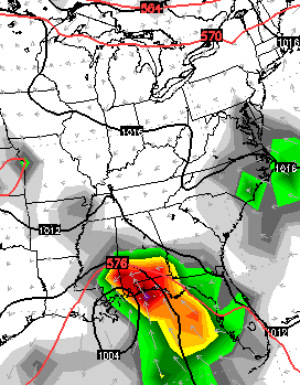
Once into late this weekend and early next week, almost every single forecast known to man develops a tropical system in the Gulf of Mexico…
If we can get something to develop in the Gulf (that’s a big if this season), we could very well get some rains from it here in the bluegrass state. This is especially true given some of the seasonal analogs developing with this dry September. 2002 is among the years now getting my attention and it gave us big rains from Isidore and Lili in late September and early October. Both were from the Gulf.
With such a changeable pattern possible this week, I may to do some multiple update days. Have a great Monday and take care.

Excited for the upcoming pattern because things have to turn more active around here eventually, right?
Also looking forward to multiple updates from Chris in the coming days!
I understand your feelings: Comfortable weather but boring pattern:{
OLD SCHOOL WINTER is a comin!!!!
Haha earlier this year was pretty old school. Maybe it will happen again.
Very possible. That, or a LOT of cold rain. My guess is if it is old school, it could be the heavy wetter stuff and at least one hit of ice. Could be low sleep times for CB.
I notice some forecasters in the Commonwealth calling for above normal temps for the next 2 possibly 3 weeks with very small chances of rain.
I need the rain but hoping not this Sunday evening. Need clear skies for upcoming supermoon eclipse.
I stumbled across this buzz on the internet about wed Sep 23rd (this wed) something major happening like an asteroid hitting the earth type major event………Fear mongers most likely – I hope they are wrong.
Well if they re right it doesnt matter anyway, does it lol?