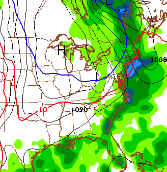
Good Thursday, folks. My weather talk since this past weekend has been to watch for our weather to come from the east. The overall flow continues to go against the grain and that’s actually a good thing for Kentucky. Why? Because this looks to give us our best shot at some rain in, at least, the past few weeks.
Low pressure along the east coast is combining with high pressure in the northeast to create a lot of wet weather to our east. With our flow coming from this direction, it’s looking more and more like we can get some decent showers in the coming days.
The first batch of showers arrives in eastern Kentucky on Friday and spreads west from there. Additional waves of showers and some thunder then develop and work against the grain. The NAM is very impressed with this setup and delivers some healthy rains Friday and Saturday…
That may be overdone, but it’s a good sign for some rains around here. All other models bring showers our way, as well. The threat for showers will stay with us through Sunday and into early Monday. That doesn’t mean it’s going to rain during that time, but the chance is there.
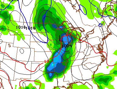
Looking into next week, development in the Gulf of Mexico is still likely as the models waffle back and forth on what to do with it. The GFS keeps brings the system into Louisiana before it gets drawn northward ahead of a cold front diving in from the northwest by the middle of next week…
 That’s from the GFS and the same model then slams a cold front through here a few days later…
 The same model runs is suggesting a pretty active pattern with another strong system coming in behind it into early October…
 I will have another update later today. Until then, make it a good one and take care.

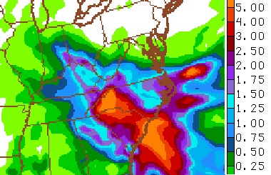
Lexington is now officially in a “moderate drought” according to the US Drought Monito.r Good news is that the GFS 2-week precipitation has been increasing significantly the past few days. It was showing 0.01″ of precip. for Lexington a couple days ago and now it is showing 4.51″ on the 06z run. All other models have been trending wetter also, so that is promising news. Hopefully pattern turns back to normal and wipe out this developing drought.
Weather Prediction Center is not as robust with QPF amounts as of their report this morning. Up to an inch or so for far east Kentucky but diminishing amounts the farther west one travels. Hey, any rainfall will help.
A lot of cirrus clouds filtering in from the ESE in Harlan Co., beautiful day:)