Good Friday, everyone. Showers are arriving on cue from east to west across the bluegrass state today. This action will put down some needed rains for many areas through the weekend. In the bigger picture, this looks like the start of a pretty active weather pattern across our region and the country.
A lot of tropical moisture is streaming our way from the east and southeast. That means rounds of showers through tonight. It is not going to rain all the time, but a few heavier downpours will be possible. As the rains move in later today, temps will really drop into the low and middle 60s.
Scattered showers and an isolated storm will be with us from Saturday into Sunday. Highs Saturday should hit the upper 60s and low 70s with pockets of warmer temps. 70s should be common on Sunday.
This is NOT a washout of a weekend, though a few areas could push close to an inch or so of rain before the weekend is over. I’ll take it! 🙂
The next item up for bids is a possible tropical system in the Gulf of Mexico. The models continue to try and figure out what to do with this thing, but the GFS and Canadian agree somewhat on how to play it…
Candian
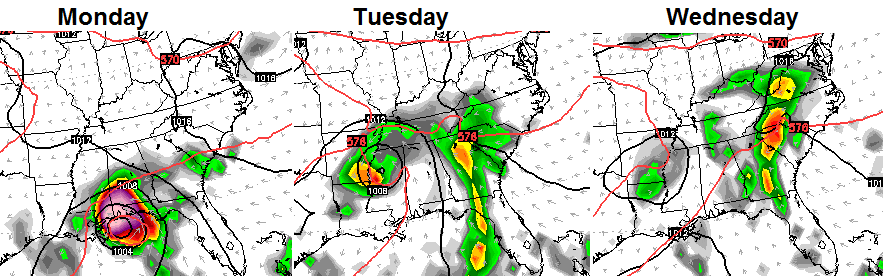 GFS
GFS
 As you can see, they have some timing differences, but both do bring some showers our way from that system. The GFS has a front sweeping through here around the same time with a nice cool down behind that.
The medium range models continue to indicate a very active pattern as we head into early October. The European Model has a nasty look for the first weekend of the month…

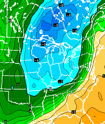 Yowza! If that’s correct (BIG IF), you would see a lot of rain and thunderstorms followed by windy and cold weather with a frost threat.
The GFS tries to do something similar just a few days later…
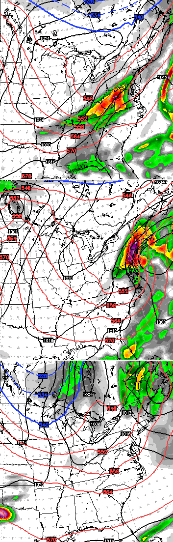 I am not saying to take any of these models verbatim, but I do think they are giving us a glimpse into where the pattern is going as we head into October.
On a side note, we’ve had October snow in Kentucky for 4 straight years.
I leave you with your rain trackers…


Make it a great day and take care.

Could we make this October #5? October is very similar to March in many ways, except it gets colder over time. This upcoming October will bring the most drastic change in weather since March and April as colder weather invades the entire northern hemisphere. Transition into winter is going to start to take full effect in about a couple of weeks meaning a lot more active pattern ahead as we head into next month. Cool/cold weather fans rejoice! (Crazy to think we could see our first flakes in less than a month possibly!)
I agree, October snow sounds GREAT!
I have already had a little rain overnight in Harlan Co. with the radar fairly active just to my east. I hope I can squeeze an inch or two out of this and maybe prevent a very dry, low monthly September rainfall from being recorded!
I love it. Bring on the snow frost and all.
A steady, soaking rain has Harlan Co. in its grips! I have 0.53 inches of rain so far, most of which has fallen in the past hour.
Now up to 1.34 inches with a short break in the action…still looking to the east and southeast at more coming!
A solid soaking, but nothing extreme. Very nice.