Good Saturday, folks. Frosty conditions were noted across much of the region this morning and the coldest is still to come. Readings drop into the high 20s over the next few mornings and that means the growing season is over. Of course, if you’re a regular reader, we’ve talked about this weekend cold blast for nearly 2 weeks. 🙂
Once we get past this big cold shot, better weather moves in for the week ahead. As that’s happening, the overall weather pattern will take on a very active look and could get a helping from the tropics. A late season surge of tropical activity appears to be on the way.
The first area to watch will be the Gulf of Mexico for the next week and change. This happens as a cold front moves our way from the northwest. Some of the models show the mid-week front wimping out, but have the next front picking up a tropical system from the Gulf and moving it our way.
The Canadian model shows this next weekend…

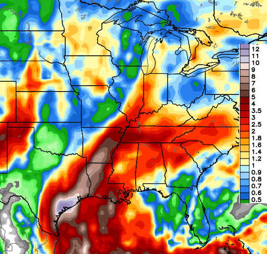
Check out that massive plume of moisture showing up on that same model…
The European Model is a touch slower, but has a very similar theme…

Given that kind of setup, some wild solutions are on the table for the final week or so of October. From there, we may see another system try to pop somewhere in the Caribbean.
As all this is happening, the snow pack across the Northern Hemisphere should rapidly expand. The European Ensembles show this well over the next few weeks…
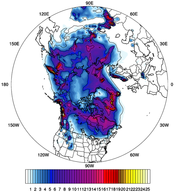 If you’re a local winter weather lover, that’s a sign that should put a smile on your face.
Speaking of winter weather, the new JAMSTEC winter forecast is out. This model has been very consistent in showing a colder than normal winter around here…
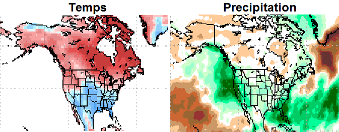
You can also see the above normal precipitation around here and, especially, to our south and east. Purely based on the looks of that, one could surmise a very active storm track from the Gulf up the east coast. Hmm.
More winter talk with the next update.
Enjoy your Saturday and take care.

Just a quick question. Why are so many forecasters saying a warmer drier winter for KY due to El Niño? You know we trust your forecast more than others…so just wondering why such a big difference from one forecast to another?
Thanks for the kind words, Jeff. To be honest, there are very few actual weather forecasters anymore. Many are just weather reporters who repeat what they read from NOAA.
Thanks CB!
It may be worth repeating what you have sounded off on many times. If this was going to be a close repeat of the powerful El Nino of 1997-98, there could be a decent chance of a typical El Nino winter for our area (including above normal temperatures).
But as Chris has touched on, we are somewhat in uncharted waters with this El Nino considering – among other things – the very warm waters off of southern Alaska/western Canada along with this El Nino’s warmer equatorial waters being farther west of South America than in 1997-98.
Very interesting times, no lack of anticipation this fall!
Car frost = saw plenty in the city this morning at sunrise
Ground frost = didn’t see any in the city this morning at sunrise
CB, throw us a percentage chance of receiving accumulating snow again this October. (hopefully Halloween snow!!)
I know the farther east and southeast in KY you go, one can usually suspect more of an impact from east coast hugger storms. I live about as far SE in KY you can get so bring on the excitement this winter:)
lol–suppose to be expect, not suspect:)
What happened to the possibility of there being snowflakes this week? Near 80 temps this week.
80? Snowflakes? What?
Makes you feel any better I guess depending on where your at in KY some might get close to 80 degrees on Wednesday. Especially if you visit the Louisville International Airport stupidest place ever to have a official temperature reading zero common sense was used. The possibility of any snowflakes this week that’s not happening, who predicted that anyways?
Looking forward to more winter talk with the next update!
lovewilbrew, were do you live Florida. Only readings i”m getting around here is 60-70 thru the week.
Thanks, Chris.
Bring on the winter talk II!
I love this time of year esp on the blog.I am excited for some winter weather that’s coming.We Will have to take what we can get.Chris what I read is the weather guys are saying we are in uncharted waters I said well I already know thanks to Chris.I will follow the blog closely as I always doThanks Chris for making the weather something even I can understand and also thanks for making it fun.Everyone bundle up and have a great evening.
Thank you Chris you are a true meteorologist. Keep up the good and accurate forecasting. Kerry nelson in mt. Washington ky.
At BGA it is 48*, but at my house, which is in a valley only 8 miles away , it is 38* already!