Good Wednesday, everyone. All signs continue to point toward some rather drastic weather changes as we roll into the weekend and, especially, next week. The setup ahead can sometimes lead to interesting conditions across the eastern half of the country.
Let’s talk about the weekend before getting into the “interesting” part of the program.
A cold front moves into the region late Saturday with an increase in showers and a few thunderstorms. Winds will be very gusty as this front sweeps in…
 Locally heavy rains will be possible as temps come way down by Sunday. We may not get out of the 50s as the rains fall.
The setup behind that system is the one that keeps giving us a late fall/early winter look. Low pressure develops across the deep south as a huge push of cold air dives in behind another front in the plains. These two try to meet up…
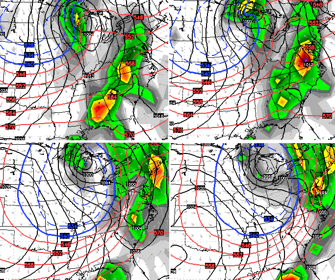
 That’s the Canadian Model and shows a blast of cold behind the departing low with rain and snow showers from the Great Lakes to the Appalachian Mountains.
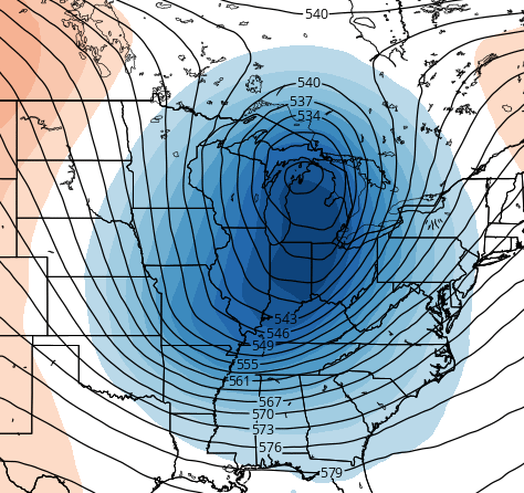
That same model run has shows a very potent upper level system driving all this…
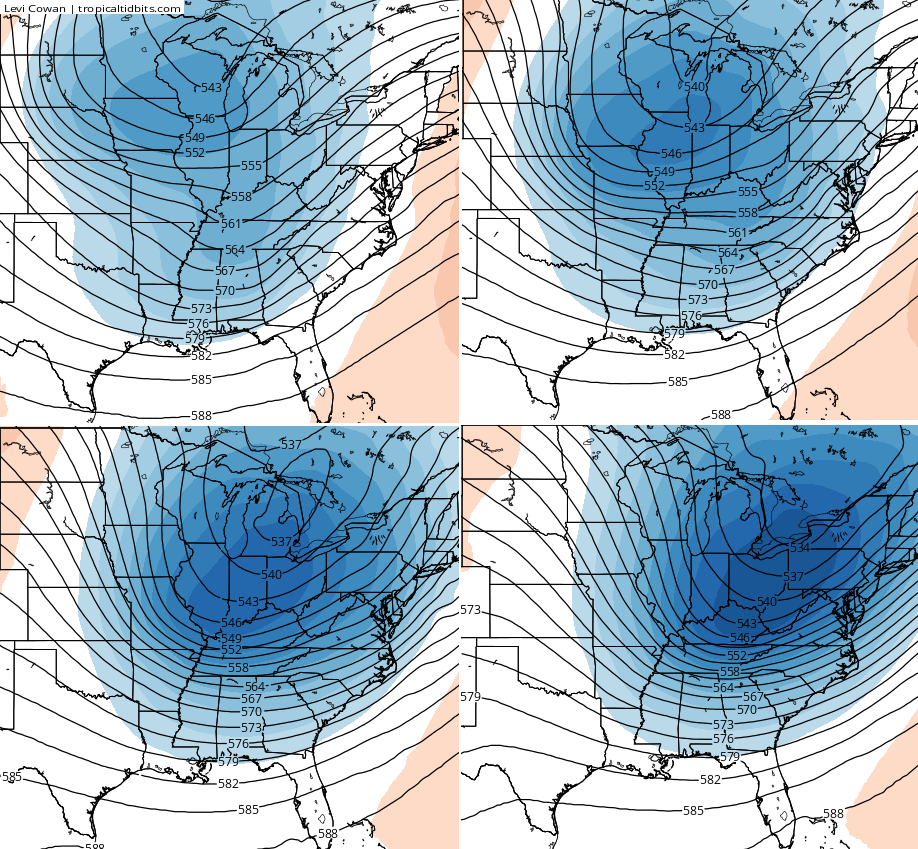
The European Model continues to go in this same direction with a deep trough digging in here…
 The European shows our northern stream system diving in trying to phase with the storm across the south…
It doesn’t fully marry the two like the Canadian, but it’s getting there…
For now, this is just something of note for us to track as we get ready to close our October. The models will likely change from day to day with the overall evolution of next week, but a similar theme should prevail. Have a great day and take care.

Funny how CB starts his blog with Saturday’s weather on a Wednesday as if Today-Fri. doesn’t exist. I’m sure he doesn’t even need to mention it because everyone knows what to expect haha.
thank you Chris Maybe a close repeat of last year do you think with upper.level wind fields and dynamics some severe weather is possible sSaturdayafternoon just thought iIwould mention it Kerry from mt. Washington.
thank you Chris do you think some severe is possible Saturday due to strong upper.level dynamics.
We’re getting into the time of year the models struggle more locking on to a solution.
Last evening, someone mentioned to me that many meteorologists are saying we will have a mild winter. I think you touched on that prediction in a previous post. From where is this coming? I am a snow lover, and resort to covering my ears when I hear no-snow forecasts.
Lucy, we can use 1982-83 and 1997-98 as analog years to compare our current El Nino to. El Nino typically means a mild winter because a Large, deep low pressure can setup south of Alaska and force warm pacific air into Canda, which inhibit cross polar flow in the United States. However, this years El Nino does have the possibility of weakening in December, as it may hit its peak a little faster than the analog years mentioned above, which could result in a more dynamic/stormier pattern that we saw earlier this year.
Take that information with a grain of salt, I do my best to understand meteorology and am self taught so hopefully that was accurate 🙂
This El Nino looks nothing like 82 or 97
I have seen a lot of forecasts for the winter talking past El Nino and comparing it to this one. Basically they are showing what happens during these El Nino and then basically forecasting those types of trends. Warmer than normal to normal around here and a little dry seems to be the theme.
But your track record compared to theirs I will side with what you are going with. So if you come out different you are the better bet.
I think I will hang out on your blog. I know you posted about the winter outlook. I will look back and try to find it, and look forward to more information. Thank you for the in depth posts.
Thank you. I am definitely hoping for the cold and wet scenario rather than warm and dry.
Thanks Chris, and welcome back. I know you had other things on your mind last week so thanks for keeping us updated. We are just starting to get some nice color here. Not ready for the white stuff until November. (No, close doesn’t count!) ;). Have a great Wednesday everyone! Remember, today is…..Hump Day! ( sorry, couldn’t resist)
I just happened across the Weather Channel’s forecast for this winter (went to check the current temp) and heard the sad news that they expect warmer than normal temps and lower than normal precip for the winter. 🙁
As far as I`m concerned the Weather Channel`s winter forecast is irrelevant.
I’m mad at KU – I do budget billing with them. My budget is 146/ mo, K?
Now, my power bill has went a little over budge this summer, however, during this time of year, when I hardly run heat/AC (12 days and counting), my last bill was only 89 dollars (LOL), but my budget went from 146 to 169!! WHY???? I could have made up the difference these next 2 months as long as it doesn’t turn bitterly cold. I wonder why they would change the budget when the settle month isn’t even until January?