Good Friday, folks. The last week of October is upon us and the weather pattern is about to kick things into super high gear. The overall setup will send rounds of heavy rain, storms, high winds and, eventually crashing temps our way. Buckle up!
Today’s weather is nice for much of central and eastern Kentucky, but late day showers and storms may move into the west.

The action increases from west to east later tonight into Saturday. The best chance for rain comes Saturday afternoon into Saturday night. Locally heavy downpours and wind gusts of 30mph will be possible.
Rain will be with us to start the day Sunday, but that slowly shifts southward during the afternoon and evening. Dry weather tries to win the battle during this time with readings in the low 60s.
Monday looks mainly dry and breezy with a small shower chance. The main show arrives later Tuesday into Wednesday in the form of a potent storm system
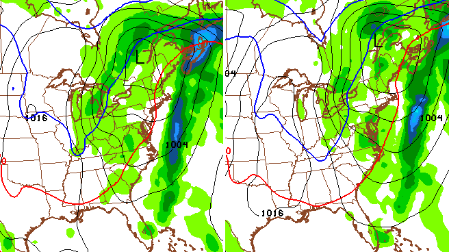
The possibility of a cold front picking up something tropical/semi-tropical from the Gulf of Mexico has been talked about many times here over the past week. The models started picking up on this potential several days ago and continue to do so. Here’s how this may play out…
 If things play out that way, here’s what that may mean for Kentucky:
– Widespread rain and thunderstorms
– The potential for a few strong thunderstorms
– High wind potential
– Much colder air coming in as the storm cranks in the Great Lakes
You can really see the cold air sweeping in here on Thursday…
That could keep temps in the 40s for highs.
I will have another update later today. Enjoy your Friday and take care.

This time of the year, vegetation no longer takes in as much water as it does during the spring and summer growing season; thus, flash flooding can occur quicker in the later fall/winter season which we are entering into. We in KY may not flood next week, but later on in November with repeated storm systems, some areas could get into trouble….
The Breeders’ Cup press releases are using a forecast that has temps near 60, no rain, and winds around 8 mph for next Fri/Sat.
The fans around the country think it’s going to be dry and lovely all next week. Ha!!!
We know better. (unfortunately)
And so the Oct. snow streak dies before it’s old enough to start 1st grade. Oh well, it was nice while it lasted.
We certainly don’t want any flash floods this time of year, as Terry mentioned, but some moderate to light rain every few days would be great to help us get through fire season.
No doubt in my mind that this El Nino has shaped the Pacific waters enough that the strongest hurricane ever for the central, east, and north Pacific waters is about to pummel the western Mexican coast. This 200 mph+ storm should rival other strongest cyclones ever recorded.
Tropical Cyclone Olivia (1996) produced a 253 mph wind gust on Barrow Island, Australia…a world record.
When I saw that 200 mph wind speed on tv, thought that was a typo. Make one’s spine shiver.
This Mexican hurricane is also tiny in size. In that respect, reminds me a bit of Cyclone Tracy (1974, about a decade before I was born) that devastated Darwin in Australia.
http://en.wikipedia.org/wiki/Cyclone_Tracy
1959 hurricane (unnamed) was also a Cat 5 and impacted almost the exact areas that Patricia will affect, almost the same time of the month in October.