Good Saturday, everyone. The final week of October is underway and the quiet weather days are now a thing of the past. This pattern is kicking it up a notch or ten as we close out the month and roll into early November. We have no shortage of weather to track during this time.
Speaking of tracking, I’m giving you guys a brand new tool to play with. I’m in the testing phase of an interactive radar that may become a permanent fixture on the blog. This has all the bells and whistles… street level radar, 60 minute looping radar, watches/warnings, storm reports, storm tracks, temperatures, winds and live storm chaser cams. You can also take this bad boy and show the weather anywhere in the country.
Give it a spin and tell me what you think…
Gusty winds will also highlight our day as the cold front moves in. We could see gusts reaching 30-35mph at times this afternoon and evening.
Showers should taper off from northwest to southeast on Sunday as cooler and drier air moves in here. Temps will be in the 60s.
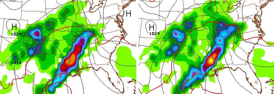
The setup from Tuesday through Thursday continues to get my attention. Our low in the Gulf will lift northward into our region and combine forces with another system diving into the Midwest and Great Lakes. The models are now quicker in bringing the heavy rains in here with many showing the actions starting late Monday. Watch the progression from Monday Evening through Wednesday Evening…

That low REALLY deepens as it lifts northward and merges with the Lakes Low. This means we have to be watching for high winds and severe thunderstorms. That’s especially the case late Tuesday into Wednesday.
It also means quite a bit of rain could fall. Check out the model forecast from today through Thursday…

We should catch a windy break in the action from late Thursday into Friday as colder winds blow. That break appears to be short-lived as another potent system takes aim at the region Breeders Cup/Halloween weekend…
The pattern favors a significant storm system cutting off from the main flow somewhere in our region and points south. Exactly where that happens remains to be seen, but the GFS keeps that system in our region for several days.
The end result is more heavy rains and storms. The GFS two week rainfall forecast…

Listen, the pattern taking shape for the end of this month into November has an extreme look to it. November is likely to be a month that gives us an increased threat for big wind events, strong thunderstorms and the first snow of the season. I think it’s a volatile month to say the least.
I will update things later today. Make it a good one and take care.

I just wonder what it would take to be part of that service as a storm chaser so that people could click on the chaser car in the program and view my chases?
Thank you CB!
The new map is great!
Love it!!!!!!!!
Thx for all you do!
🙂
Just wondering what the first week of November will be like? CB has been spot on with the weather. Maybe cold!!!!
I am so grateful for this site and the new gizmo is awesome!! Thank you for allowing us to all to get our “weather geek” on.
Love the new radar. Lots of options.
Uh, well, I hate to say it but this radar clearly doesn’t work well. It’s been showing all of this green everywhere since about 3 A.M. and we all know it isn’t supposed to rain until this afternoon or this evening. 😉
I kid, I kid. I was just kinda banking on that to be accurate for a couple things I needed to do this early this morning but it’ll all work out. My neighbors on the street with their morning yard sale plans (they were going for an 8-to-12 window), they’ll likely be grumpy for a while longer.
The radar looks interesting. Thanks CB! 🙂
Disappointing that we’ll be seeing the latest start to the snowfall season in 5-ish years.
Nov. sounds more exciting than a UofL recruiting campus visit!
Like the new gadget…Good stuff. Know you are busy, but the twice a day updates also super when active weather going on. More exciting that a U of L recruiting visit is funny!!!
Love the addition, bring on the cold and snow!
Love the radar and this blog. Keep up the amazing work Chris.
Map is keeper! Nice!
New radar is good but still think I like the breakdown on the regular one. Pretty neat though. Think it’s gong to be a very wet and windy week upcoming. May need to bring outage waders! Thanks Chris for all you do. Have a great Saturday everyone and GO CATS!!
I like some of the features on the new radar but I’m with coffeelady in that I like to look at the precip. on the old radar. Also, it took a while for my computer to load this new radar with the precip. being much later to load. Sometimes I just like to take a quick look at radar and I don’t think I can do it with this new one, at least as it is now.
I love the new map.It was a beautiful week of blue skies perfect weather not one cloud in the sky this past week but in KY we know that a change is soon upon us.I love the seasons now I am ready for some snow.Chris is too I can tell.Thanks Chris.
I can’t wait til snow is flying…living back in SE KY. looking forward to winter
The new map has some nice features but is very slow to load making it almost not usable. I found myself going to intellicast for the radar today, which i usually never do. I might use the additional features if they performed better, but the majority of what I need the old radar was better at than the new one. You’re my first read in the morning and last at night. Thanks for all you do!