Good Wednesday, everyone. Gusty winds continue to blow rounds of heavy rain across the region early today. This action is ahead of a strong cold front that sweeps through here later tonight. As all of this is going on, another potent little system looks to move our way later in the weekend into early next week.
Let’s dance with the one we have out there today before courting the next system.
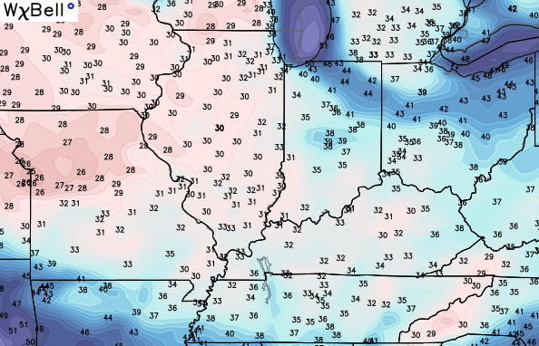
The morning is very wet with showers and embedded thunderstorms working through the region. Locally heavy downpours and winds gusting from 30-40mph are possible. We should see some breaks in the clouds this afternoon as temps keep spiking well into the 60s.
The actual cold front moves in here later tonight with another band of very gusty showers. Temps behind the front drop quickly as dry, chilly air sweeps in from the northwest. The air actually grows cooler as Thursday wears on and should bring us low 30s by Friday morning…
The rest of Friday looks stunning with highs in the upper 50s with partly sunny skies and a nice breeze blowing. That makes for awesome weather for the opening of the Breeders’ Cup at Keeneland in Lexington.
This brings us to Halloween. Trick or treating, college football and this little horse race known as the Breeders’ Cup are all packed into the afternoon and evening. Nice weather would go a long, long way in making this a memorable Halloween. But, can we make that happen?
A storm system developing across Texas will cause a healthy rain shield to develop just to our west Friday into Saturday morning. That moisture slowly works eastward into Kentucky, but has to overcome some dry air. The GFS has some of this drying up as it moves in…
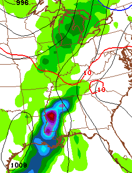
That would only give us a small threat for a shower. Other models have been more aggressive with the threat for afternoon and evening rains. Here’s the European Model…
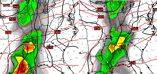 This system then really increases as it moves our way later Sunday into Monday…

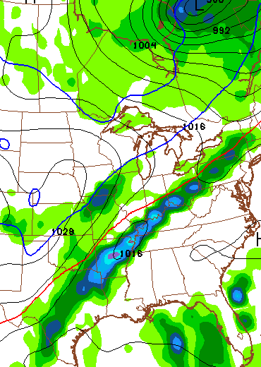
That would mean another big rain event across our region as we open up the month of November.
Once that system moves through, temps are going to take off with a serious case of Indian Summer breaking out for the middle and end of next week. Highs will likely reach the 70s!
That won’t last too long as signs point toward a powerful fall cold front sliding in here late next week into the following weekend…

That should be a big temperature swing moving through here and could lead to some decent thunderstorms as it does so…
I will have another update later today. Until then, you have your choice of radars to track today’s action…

Have a great day and take care.

Since you began posting the new interactive radar, I’ve experienced difficulty with the website. It keeps trying to load the page with text flashing on and off, the maps disappearing and reappearing. Has anyone else reported these issues? I’m using an android mobile device, Samsung Galaxy Note 4.
None. I’m using a Samsung S6 active android I have zero issues.
I have an s6 and have had no problems
No probs on my windows laptop
Thank you CB. God bless you and your family.
I have nothing but crashing issues loading this blog with my ipad on safari. This was my go to place for weather information, but crashing and reloading 8, 10 times before I can proceed is maddening. Thanks for the weather info Chris but until I can come in here without crashing, I will have to go elsewhere for my weather. 🙁
Same here
Thanks Chris. Last Halloween it was cold and rainy I believe. We had and are having again a Fall Fest at our church and I remember being dressed very warmly. Our football game is in the early afternoon so maybe we can get through it before the rain sets in! Don’t know which football team will fare better in a wet atmosphere, UK or UT. Maybe neither. As for the Breeders Cup, here’s hoping the rain holds off long enough for it to be done. Guess we’ll see. Have a wonderful Wednesday afternoon everyone. Thanks again Chris.