Good Monday to one and all. Our mega front is rolling quickly across the state right now bringing one heck of a temp drop with it. Our WINTER STORM ALERT rolls on with many areas gearing up for a some hefty amounts of snow and ice tonight into Tuesday.
Here is a look at the current warning/advisory map…
Look for northern and northeastern Kentucky to be added to the warning list at some point later this afternoon or evening. As i mentioned… the cold air is crashing into the state right now. The models still appear to be a little slow in catching on with just how cold and dense this low level cold air really is. The NAM continues to grow colder with each run as it should because it has the better resolution to handle the low to the ground cold air. It is the model of choice right now by a long shot.
Check out the temp prog from the NAM. The black line is the freezing mark…
Early This Evening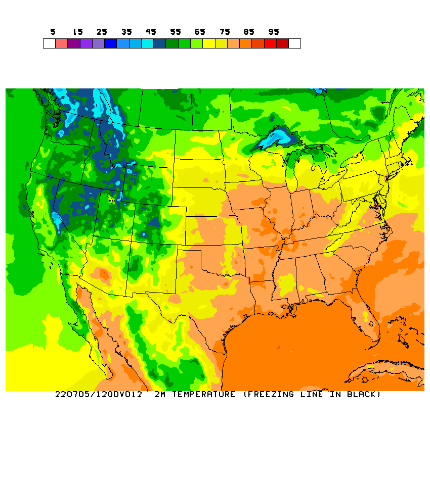
Tuesday Morning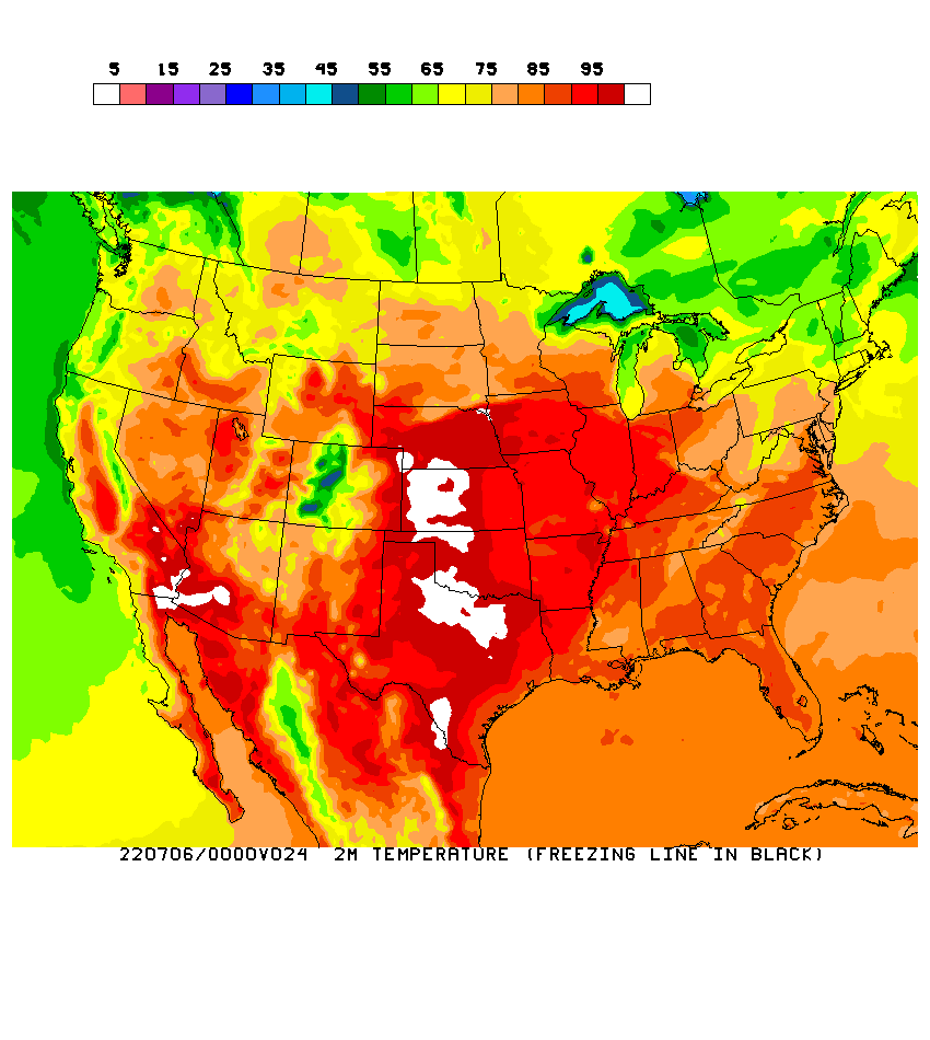
Tuesday Evening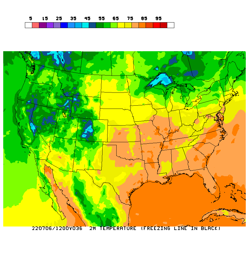
The NAM keeps much of the region at or below freezing for most of Tuesday. As a matter of fact… it keeps northern Kentucky below freezing through Tuesday night.
A wave of low pressure is developing to our southwest and will bring a lot of moisture into the state later tonight and Tuesday. Some of this could be heavy early Tuesday. The precip will take on varying forms including, freezing rain, sleet and snow. Here is a map of my latest thoughts…
That could, and likely will, change later this evening as we see how the temps are trending. The setup is there for some areas to get enough freezing rain for an out and out ice storm. This will not be like the one back in 2003 as we don’t have the same amount of deep moisture!! 
I will update things as needed later to day so check back! Take care.
Select Page

Any idea what time the icing will begin for Lexington?
according to the NWS noon forecast discussion, temps will fall below freezing between 4-5 pm in Lexington
I got plenty of deer meat in the freezer. If we lose electricty, we’ll just put it out in the cold.
ty CB, I wish u was wrong on this one, dont need any more rain down here.
isnt the front going to rider back north with WARM AIR by tomm eevning on.
Thanks Chris…NWS Jackson just added the Tennessee border counties to the advisory area (as of 1:05pm).
Thanks for the update Chris. As usual the line serperating the areas of different precip lies right on top of my house..lol Guess I’ll have to wait and see what decides to fall from the sky.
Thanks CB. I am not looking forward to the ICE.
Chris I asked this on the last post why don’t we do live blogging?
Thank you for the update Chris. You are da’ man…don’t let anybody tell you otherwise bud!
This little wave riding up the front tonight…let’s hope that puppy squeezes out some good precip. I think the morning rush hour is going to be a very interesting one. People will likely want to allow extra time to get to work tomorrow.
Thank you Chris! Frankfort is already 32 and Lexington is still 41. The edge is just getting to Woodford Co. The rain is coming pretty steady right now, but no icing as of yet.
Marsha, I imagine Chris is getting ready to go to his real job, but I’m sure he’ll pop in on us when he can.
i think nws has excellent handle on this one from what data shows…lex area 1-3 with significant icing likely, of course as you see on CB’s map the significant snow line is inchin south across scott county, interesting and sleepless night to say the least lol
Good map there Chris…my thoughts are about the same, but I would have your blue line just a bit further south. I still think Lexington is still looking at some decent icing. But I agree it does not look like 2003. I worked that event at JKL. Historic flooding in the south on the Cumberland River…major ice storm in the north. Great Ohio Valley weather…
afternoon music
politics, relgion and her by Sammy Kershaw.
sad deal that this song not on youtube, great video it is.
there is 2 redneck boys that sing it though.
one of the greatest country songs u ever hear.
Sorry, read the temp wrong, It’s 37 in Frankfort and 34 in Louisville!
41 here at my house in lex as well, last time i saw this temp gradient was decmber 2004 blockbuster storm that brought near 32” of powpow to southern indy it was 14 with blizzard conditions at paducah with showers and mid sixties in jackson. AMAZING
hah. I’ve done that one too many times (sleepless nights, for various reasons), only to realize school was not cancelled the next day.
MJ i was 13 when the 2003 ice storm hit me and my family drove up from knoxville tn on 75 it was plain old raing and literally nothin…even into richmond but when we crossed the ky river in northern madison county the full brunt of what had occured was obvious, that was an amazing cutoff between rain and historic ice storm, i remeber the roads were a mess in TN, flooding and mud slides in hills north of knoxville
haha you and me both my friend, i remeber it all started in 5th grade my life entered chapter two “the weather weenie snow lover” lol of course by now i am used to the dissapointment but when i am out of college i am heading west maybe to the san juans or alaska range and live on denali lol, get my snow fix i crave
Patty, I guess he’s very busy he keeps us up with our weather plus his job we are so lucky we have him…. Have you hear from Crystal I hope she’s doing ok
OK so just so I understand, vinny, tommy, chris, mitch, mj…. chris thinks that my area (between morehead & ashland) will be under a winter storm warning sometime today?
See, I’m just the opposite. I hate winter. I’d rather live on the beach where its 85 all year long.
Don’t get me wrong, I love a snow day like everyone else, but the sucky thing about a snow day….is the snow.
Hurricane party anyone???
that is correct…
Thanks for the update CB.
I love snow, but I do not want the ice. I was single when the 2003 ice storm hit. I was fine though without power. I stocked up on beer, set all the food from the fridge outside and grilled out every day:)
Now, I’m married with two little ones. I’m better prepared (heat wise) to be without power, but I dread loosing the juice.
Oh, and thanks for you seeing the chance of this storm last week CB. I won’t have to run to Kroger for supplies, I did that yesterday:)
Any ideas if its gonna do anything up in flatwoods(greenup co)? It seems like the storms always miss us either to the north or the south. Hate to get ice but would love some snow!!!
Like my earlier post i think the map Chris put up is exactly what i said haha. but yes John in Flatwoods it looks like you will have some interesting weather. I believe the greenup co. area could see anywhere from 1-4 inches of snow and 1/2 an inch of ice or more further north more snow further south of where you are more ice you look to be right at the battle ground area where it could be heavy snow or a signifigant icing. Be careful out there and be prepared.
were all different or else things would be pretty boring lol, i can appreciate the beach also but the high plains rockies deserts and canyonlands is where my desire is, i spent last summer wandering them, i never had such a blast!
What was cool to me with that storm is that in Jackson, just the tops of trees were coated. I remember driving up through Wolfe and then into Powell county and I could see the icing descend to the surface the further north I went. In that case, you could see how shallow the cold air was around JKL, but was deeper the further north you went.
BTW, HPC has backed way off on the precipitation amounts. They believe the models are over doing things. Am not sure what to think about that.
35 and heavy rain in lexington at my place, and a slight bit of wind, not too windy though the anerometer broke
radar to the sw is really blossoming
Winter Storm of the season is at hand and the blog is DEAD….
Any updates from the experts..?
…
I’m definitely not an expert, but my forecast for Carter County is .25-.50″ of ice and 1-3″inches of snow… Write it down in Permanent marker! lol
Doesn’t look like we will have to go get the kids Vinny.
that’s a GOOD thing…! lol
it’s cold out there…
…
WAIT A MINUTE !!!..WHO IS trying to rain on mine and ANDY’S BBQ…lol…SOMEBODY went and run the HEATMIZER OFF and now the tropical 5 counties that werent in the adv. area has been included..SOMEBODY TRYING TO RUIN MY BBQ..
ROLO….I thought we were gonna BBQ some possum but the NWS is trying to rain on our parade…lol..lol…lol…
…..POSSUM…EEKKK!!! just dont think I could stomach it..maybe if I didnt know what it was..but thats a big chance I dont wanna take…:)
……………………………….
Oh well since We are now included in this mess of an icy event I hope its short lived…SNOW is fine, sleet is O.K. freezing rain is NON NEGOTIABLE!!
still toasty as of now though
steady rain
55*
on the ponderosa
vinny, what’s going on up there? temp.and conditions? got any frozen stuff yet??
Anyone else having trouble posting here or seeing Chris’ post???
BTW…I think everybody is over at Belski’s LIVE blog, so a head’s up…DO NOT TRY IT…he’s got like 2500 ppl already on it and he is probably thinking he royally screwed himself..lol! He’s running about an hour behind on posting everyone’s comments!!!:O
Stay safe tonight…looks like we might be in for some fun! Slip sliding away!!! (That should be the song of the day!) ha!
at my house in NW LEX:
35º, light rain
…
Maybe they’ve made this decision based on current radar trends? I think it’s hard to say…but with a disturbance rolling through tonight one would expect at least more coverage than what we are seeing now.
just alittle chilly in paducah temp. at 24* with unknown precip..
The concrete is drying out here in Gtown, hopefully things are dry for the afternoon rush. The temp has plummeted and reads 33 here. Keep the ice away, but tomorrow morning looks like a total mess.
Where is everybody?
marsha, please go away. You are extremely annoying. People have lives you know.
Its getting cold here in Lexington. Looks like its right at the 32 mark.
I’ve posted about three things over there and nothing ever made it through. I think they need another program.
um rolo, that was extremley rude!!! All Marsha did was ask where everybody was. Marsha pay no attention, i enjoy reading ur comments…
Hm,Maybe this means I wont have finals at the Corbin Campus in the morning. Anyone think a drive over the falls road will be too slippery in the morning?
Latest forecast discussion from NWS Jackson:
http://www.crh.noaa.gov/product.php?site=NWS&issuedby=JKL&product=AFD&format=CI&version=1&glossary=1
Calling all Bailey bloggers if you are over at Belski’s live blogging you better get back home before Chris get wind of it and put’s you in time out…..
MJ,
Yes, I think John B. is probably re-thinking it ALL right about now, w/ close to 4K peeps over there. I made my first post @ 2:03pm, and I don’t think it’s even up yet. If not another program, at least moderate the comments and keep the kiddo’s away with “Will we go to school in Groundhog Holler tomorrow?!”, or the adults w/ their similiar and/or sillier comments.
Apparently your life is to be obnoxious.
Rolo, you hurt my feeling ANNOYING that hurt….
Hey guys, great news on TG’s weather blog, it’s moving back to the old wordpress system:
http://wkyt.mis.net/weatherblog/
Marsha, I just went over there to
look… I won’t be going back. I have
never seen such a mess. I know where
to put my loyalty!
Jeff Megan, that’s ok Rolo is just having a bad day…..
Actually one just got through and I had to put NWS in the name so that their moderators would let it through. They got some people cursing over there and they are moderating. They have about 1000 people posting at once.
Just a quick question. On Wkyt desktop it says that Bath County is no longer in the Winter Storm Warning. Does that mean we will not get the ice now? That would be great!
Rolo,I don’t belive that’s you what is your goats named?
Well, it is still raining here at the Hargis ranch 2 (work) 😉 But the temp is going down a little bit, and the wind is picking up. Our temp now reads 47 here, and winds are out of the NNW at 8-10.
Haven’t looked at the radar for a bit, as it is raining here, I know what my weather is… 😉 but from what I am reading, I guess it is not over yet.
Tim, hang in there, we can gather for the BBQ tomorrow after the freezing line moves back north, ok?
I know one thing…if it does get icy, Grandma had better watch out for those reindeer! Stay safe, all.
Vinny, I think they all ran to Kroger…
Nothing like a good ole BBQ down on the ranch!!! MMMMM
You’re ok Marsha…
rolo:
If you need help filling the sink hole, I’ll be glad to help my friend…!
…
lmk including even far se counties in warning now.
look west thats some serious moisture lets hope most of this is snow and sleet along i-64
Its sleet/snowing now in LOuisville
That’s pronounced, Loserville…lol
…
Yeah!! They are getting the snow/sleet…
The river at Clays Ferry seems to cut off or begin weather happenings. It really is interesting to watch. I have lived in Madison County all my life and the river seems to stall out things that are headed south. I know there are a lot of hills and of course a deep cut to the river but I just didn’t know that would affect the weather so much.
QUESTION FOR MJ:… Do you think those counties along the Tn. border see any frozen precip tonight.(se corner) these counties were added to the adv. area around 1:pm. so apparently the cold air is moving farther south than originally expected…
Now, Now, people….and billy goats! Play nice! Santa Bailey is watching us! 😉
And besides that, if every annoying person we’ve ever met disappeared, I think we’d all find life just a little more boring….in the long run. In the short term might be a different story…HAHA!
Nothing special to report here in Laurel Co. Just more rain to add to the overly saturated ground.
Hey Marsha…I haven’t heard from her today at all. I have thought of her all day! I took a personal day today so I’ve been trying to do the Christmas house cleaning. Of course there was the laundry my son brought home for me to do. peewhew!
Do you think I’m annoying also?
Rolo…..put on some Eagles!
32 line reaching lexington now. the 18z NAM trended a bit slower with precip which might favor more ice over snow. south of danville in looks like just ice, someone along the 1-64 corridor may end up w/ quite a bit of sleet.
Is this going to be just a Tuesday deal. Anybody know when it will warm up or will this stick around for awhile?I have a little bit more Christmas shopping to do. I am exhausted and can not do anymore today before the storm hits. I need tomorrow to wrap, do cards and just chill out. Then I really would like to go back out on Wednesday.
I believe everyone is concerned for the periods of late this evening until tomorrow evening, but I have seen where the Northern Counties are under a Winter Storm Watch for tomorrow night? I live in Flemingsburg, just about 7 miles from the Mason County border; so with that being said, could we be dealing with Winter Weather Tuesday night also?
ok my blogging friends i must leave now i want to stay and blog but am 10 minutes late to bio final allready, i cant focus on anything except this storm my mind really is in the clouds
The forecast discussion from LMK has changed things up a little bit. They have extended the winter storm warning from 7:00 a.m. through 7:00 p.m. tomorrow. Tells me they don’t think the warm air is going to move in as soon as previously though tomorrow. Probably means more precip for everyone. Additionally, they comment that ice accumulations of .50 are not out of the question for the Bluegrass. That’s not good.
I see the WSW has been extended tom. for alot of the LMK area, and I noticed some of the southern counties in the LMK area that were under winter weather adv. are now WSWarnings..
Hi Tim:
Initially it looks like rain as your geographic location will not see the cold air until later. Thus, initial precipitation would likely be rain with some freezing rain late tonight…IF the cold air gets down that far.
I wish I could be more specific, but there a lot of unknowns right now.
Marsha, my comment was not directed towards you personally. I meant that I’m sure we all have experienced ‘annoying’ people in our own lives. If they all disappeared, sure we’d be happy in the short term…but in the long term, we’d all be bored and looking for something or someone else to complain about. Just human nature…
So calm down…I have way too much going on to be annoyed by “online happenings” right now. 😉
Tim, I notice you posting a lot. Are you in the meterological field or just a weather nut like me? I just have a feeling that the temperatures aren’t going to rebound like they are expecting. Especially if we get some sort of snow pack going. Do you think this storm has the potential to be worse than expected?
Plus,
Rolo is bi-polar, if you can’t see that you’re blind..!
(that’s a little inside joke, Right Rolo..?)
lol
Chas, please go away. You are extremely annoying. People have lives you know.
*NOTE (that was sarcasm for those of you who didn’t get it)
Lets be kind folks….
MJ:
“there are a lot of unknowns right now.”
hummm, please explain… Thanx!
…
Thanks for posting about TG’s blog. I took a look and guess who posted?!? BubbaG!!! Looks like this storm has everyone’s attention.
MJ, Chris – everyone? Can I please ask your thoughts about this evening? My daughter will be on the roads after 11 pm here in Lexington(she had to work late at the mall – ugh). I am already worried sick about her driving – what do you think it will be like for her?
Thank you for your thoughts.
I pray everyone stays safe. Have I mentioned – I HATE ICE!!!
Robert…just a middle aged weather nut..lol…Love the weather, I have since I was a kid..missed my calling in life I guess..anyways, I enjoy being a part of the blog and I’m a weather spotter for the Jackson weather office area.
……….
Where are you located?
This pattern is a MAJOR HEADACHE for forecasters right now because KY. is riding the fence with these fronts right now..now by next week all of ky should be in the deep freeze and plenty of snow chances around for maybe a white Christmas…
I’m calm I meant to put LOL out from it but my comment went to fast. But you know I’m thinking about just reading the blog stop commenting its getting really bad on here…..
Let me tell you all right now…if we see the .25 to .50 inch ice accumulation here in the Bluegrass that the NWS is predicting….that will be horrible here tomorrow. I would recommend taking this seriously.
Vinny, really I thought someone had jump into Rolo body took him and his goat hostage….
Temperatures are dropping pretty steady down here along the border. around 3 its was 56*. now at 5:05pm. its now down to 47*..hmmm could be interesting even down here. we’ll see..well gotta push off again…my sons ballgame, so I’ll check you all later…
marsha, please don’t go. Don’t let 1 persons negative comment keep u from commenting.
I can’t not comment I try that once like to drove my husband crazy.
Tim, I am located in Flemingsburg, KY. I don’t know if you know where that is since we are sort of a hole in the wall, but I am about 17 miles South of Maysville and about 20 miles North of Morehead. I probably should have done something in weather…I even drive my wife and son crazy during Thunderstorms…I’m usually right out in the middle of it looking for cloud formations…I gues I should become Storm (Tornado) Chaser LOL.
It’s 35 here in our end of the world. We’re curled up in the house ready to stay here for as long as needed. I really hope the ice stays to the north. Everyone please make sure your outside animals are taken care.
Heavy, accumulating sleet falling here in Madisonville (Western KY). Precip shield filling in.
I just sent all office personnel home…I’ll go soon
Bailey on WSAZ right now… He just said it’s all about location, location, location… 3-6 inches for Northern Ky into Ohio and 1-3 inches with ice for Lexington, Grayson, Morehead…. He says he’ll be updating his weather blog!!! lol
Marsha, don’t stop posting. I am not even sure that it is really Rolo who wrote that posting…it doesn’t sound like him at all.
My dad just told me that eastern ky is in the winter storm warning, he saw it on the channel four news(Johnson County). Anyone else heard about this?
Well…
The unknowns are:
1. How deep will this arctic air mass be?
2. How quick will the southwest flow of air aloft scour out the cold air near the surface.
Very complicated forecast. Some are going to be delighted while others will be disappointed.
I SWEAR ON MY LIFE THAT I DID NOT POST THAT ABOUT MARSHA.
I SWAERR TO MY GOODNESS, U WANT TO USE MY NAME WHOEVER U ARE U BEST OWN UP TO IT.
JESUS, CB if u could run that IP on that post I apprciated.
I tell u what, marsha sweetie I would never attack u, I like u and everybody.
once again that was NOT THE REAL ROLO that made that post.
Hey Chris, someone is on here impersonating Rolo and slandering his name. Seriously, I been on with Rolo this afternoon and to you guys who are being referenced in these posts, disregard them.
I am an avid reader of this blog, and I would have been s out!shocked if that was really Rolo!!!
Watching the weather here in Lex as we get closer on the radar – very interested to see how all of this play
vinny I am a mess at times, but I never posted that. somebody being a punk.
they are a COWARD if u ask me, u got a problem with ME and MARSHAu might want to grow a pair and say it to our face.
I act a fool and stuff, but I swear that was not me posted that.
I love marsha and try to answer her question if I know the answer.
its 37 in gunchester as of now.
is this precip SW going to blossom more?
Rolo, I apologize myself. Im truly sorry, I had no clue.
See Marsha? I didn’t think Rolo would post something like that. Chris can probably find out though. It’s terrible that someone would use another person’s name and post garbage like that.
megan nobody needs to apologize.
we will find out who doing this if they keep it up.
Rolo, I knew it was not you I asked them what your goats names was then I thought they had kidnaped you and the goat….
This is my blog family I’m hook I knew was not Rolo…..
Hey Rolo:
I told Chas that I didn’t think it was you…
And I was RIGHT for once…lol
…
Storm inching closer and closer… Grayson, Ky down to 37 and rainy… rain is almost finished though. Temp has dropped 5 degrees in 2 hours… 5 degrees to go!
Rolo….I NEVER thought it was you and I don’t think Marsha did either. There was someone else a while back that gave Marsha a hard time, do you remember that Marsha. Maybe that same weirdo is back.
CB will get ’em, he always does…
…
Rolo, I knew it was not you we have been on this blog from day one I knew that was not your style you are one of the nices guys on here. Who ever this was try to impresonate the wrong person. Rolo you are our blog family and we knew you better than that…..Just someone trying to stir up trouble we all need to get alone and watch out for each other so these people that get on here don’t get away with making trouble on our great blog we have going here….
Hiya, Everyone!!! 🙂
WHEW! WHAT an afternoon..lol! Trying to do my “thing”on Belski’s live blog and still keep up w/ you guys was enough to make me actually NEED my Cymbalta & Xanax!!!;)
MJ: I never did see one of my posts, even though they did a hit a slight ‘slow dip’ in responses…oh, well…?! We know now to just keep it up with smoooooooth blogging like this right here!;) UNREAL!!!??
Rolo…knew you got hacked the minute you spoke badly of Marsha…that ain’t the Rolo we know here!;) Buddy, I had someone actually find out my AOL p-word last year and was READING MY MAIL??! They would read it, then it would be tossed into the ‘read’ pile…I finally caught on and was like, “WTH!?-I’M NOT reading my own mail here…WTH??!”..lol!- Now I have such a PW that if it’s taken, there’s a much more Superior Being out there than myself….
28° and light “something-the-nother” out yonder/Bardstown.
Yes Patty that was BuckeyeFan I don’t know where he went. Guys Chris has give us something very special I guess people can’t stand that we are like a big blog family. This is not just a place to talk weather we get on here and just talk to each other like a big family if we hurt like Crystal then we all hurt I have worry about her all day just like I would hav a family. member….
what christmas MOdels looking like guys?
BUCKS over heat tonite.
Sleet changing to heavy wet snow as I speak…(thought it got awfully QUIET out there!?)
25°/Sleet/Wet Snow/Bardstown