Good Monday, everyone. Today is one of those raw and nasty weather days for much of the region. Chilly showers are working in here as part of a bigger storm along the east coast. This system is the beginning of a very active weather pattern for Kentucky and across most of the United States.
Rains increase from south to north today with the best action across central and eastern Kentucky…

Temps will likely stay in the 40s all day long in the areas with the bulk of the rains. Speaking of the rain, it should be around to start Tuesday, but clears out by the afternoon. Highs will range from 50-55.
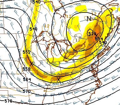
This leads us to the next storm system rolling from the plains into the Great Lakes. I’m not as impressed with the severe threat from this as I was a day or two ago. That doesn’t mean we can’t have some severe weather, but the timing of the front and lack of a strong return flow are inhibiting factors. Basically, today’s stronger east coast system looks to impact the one coming in behind it.
Regardless, the Wednesday-Thursday system is impressive. A line of showers and storms races through here Wednesday night with very gusty winds. Chilly air moves in for Thursday with a much bigger push of cold air coming later Friday. I’m looking at this system upstairs and seeing some very small disturbances diving in here by Friday night…
While there isn’t a lot of low-level moisture… that setup could produce some sprinkles of snow flurries on a northwesterly wind flow.
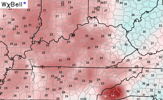
That leads us into a seasonally cold weekend. If skies clear at night, temps could approach 20 in a few spots…
From there, we watch deep troughs near Alaska dive across western Canada and into the Plains. These troughs then deepen as they work into the eastern part of the country…
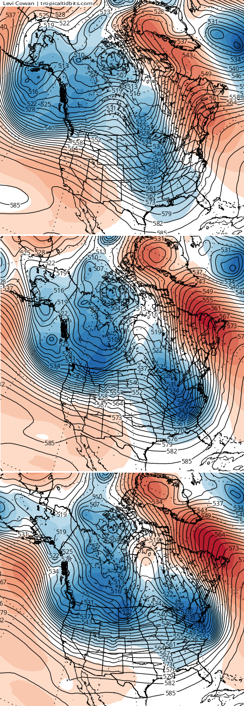
Notice some blocking showing up across Greenland with a ridge trying to nudge into Alaska on that last map. If that happens, wild winter things can happen across the country.
I will have another update later today. Enjoy your day and take care.

I can’t interpret Chris’s cryptic writing about these lows in our future :'( haha! Severe weather or WINTER weather is coming??
Yet the CPC shows an abundance of above average temperatures for a nice chunk of the east over the next 10 days or so. It seems to conflict with recent forecasts of a declining AO index over the same time period. The only way both can be right is if the coldest air stays west, like Great Basin or Intermountain West west. Otherwise, somebody’s got some tweaking to do over there.
Euro model seems to be leading the way for a warmer solution in about 10 days with temps well into the 60’s for our region while GFS and GDPS hold temps in the low and mid 50’s if it’s dry. I typically do not like to look at Euro past 7 days but was trying to figure out the conundrum I just mentioned above.
This winter seems like a VERY hard one to forecast
The blowtorch is coming.
I’ve follow Chris for about year now and he’s has hit the nail about 99 percent of the time. So don’t go and read different models and trying compare what your read and his models.
I have a message for you on my blog…
BM, Mike S is good people and extremely knowledgeable weather wise, no need for your comments. Mike S has nothing but respect for CB.
Mike s. And prelude i wasn’t trying be disrespectful to anybody. I don’t know who is mike s is hes got his opinion and I got mine.
Why is there a huge donut hole over eastern Ky? Widespread rain to the east and west and nothing in the middle.. Looks like a nice stretch of dry weather over the next week, I’m sure the Thurs. morning precip line will die before it gets here..
A nasty day for sure but low amount of total rain here in Harlan @ 0.29 inches. Lousy storm systems lately:(
If forecast were 100% all the time we wouldn’t heed Chris and all the weather people would be out of a job. My wife teaches here in Lexington and she and other teachers always would ask me what Chris has to say about the weather. This is especially true during the winter.Chris doesn’t have to do his blog, he’s not getting paid a bunch of money for it. I just find it fun to discuss these things with other people. On a last note, I haven’t seen but a few wooly worms this fall, but the ones I have seen were a little black at the front and the back. All orange in between. Thanks Chris for all you do!