Good Tuesday, everyone. A big time storm system is developing in the plains states and will roll toward the Great Lakes. That could bring some gusty winds and storms to our part of the world over the next few days. We will take a look at that and the latest on where the pattern may take us through the rest of November.
As always, we begin with the precious present. Low clouds will slowly work out from west to east as the day wears on. There’s the chance parts of eastern Kentucky never get rid of the clouds. Some sprinkles or a light shower may even hold on into the early part of the day. Highs reach the 50s.
Our Wednesday storm system pushes our way with winds on the increase and a line of showers and storms racing in from the west. The timing on this puts the line into western Kentucky late afternoon and early evening. That line then races eastward during the evening and overnight.
The best chance for severe weather continues to be across the far western part of the state…
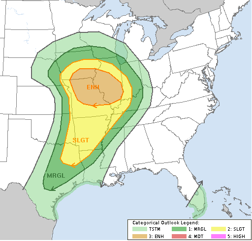
Regardless of severe storms, high winds will be a problem Wednesday night through Thursday. 30-40mph gusts will be a good bet during this time.
Chilly air comes in behind the departing storm on Thursday with another front arriving Friday. That brings some seasonally cold air for the weekend as skies stay dry.
Next week will feature another big storm system developing and rolling through our region. There is just so much energy showing up that the models vary differently from run to run on how to handle that system. That’s going to continue to be an issue going forward.
Speaking of going forward. The latest European Weeklies are out and take us into the first week of December. It shows what I’ve been talking about with a lot of back and forth with deep systems diving and lifting out. For fun, here are the snowfall totals during that time on the Ensembles mean and the controlled run…

WeatherBELL
Since Summer, I’ve been talking about how amazing this current El Nino is in terms of strength, placement and timing. There are no analogs that really come close to matching everything that’s going on with El Nino and the overall Ocean temp anomalies.
1997 was the last strong El Nino, so many in the weather world are comparing this one to that year. I’ve made no bones about how foolish I think that idea is. I’ve frequently posted images of the ocean temp anomalies from each year and they simply do not match.
This image takes the 1997 ocean temperature anomalies and compares them to the current ocean temperature anomalies. The blues show areas where this year is colder than 1997 while the reds show where this year is warmer than 1997…
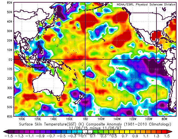
Folks, these two years aren’t really close in the overall scheme of things. Check out how much colder this year’s water is off the coast of South America. When waters in that area are warmer than numbers to the west, the United States typically sees a furnace of a winter setting up. That is not the case this year as the warmest waters of the current El Nino are in the central and western parts of the tropical Pacific.
In addition to the true El Nino region of the Pacific being vastly different, look at the rest of the Pacific off the west coast of North America… MUCH WARMER waters this year compared to 1997. In addition, look at the water profile in the Atlantic off the east coast… also MUCH WARMER.
There are many other weather folks out there who have also picked up on all these differences. I’ve actually learned a lot from some of these guys and gals through the years. Unfortunately, the majority of the weather masses don’t believe in homework and just go with “The last strong El Nino was 1997 so this winter will be the same as that year”. If it were only that easy, folks!
I will see you guys later today for another update. Enjoy your Tuesday and take care.

I appreciate you for taking your time to explain the differences with data. Unfortunately, you will still have people that will not listen to the data or are simply too amateur in meteorology to “not” listen to others compare this year to past typical El Nino events. As long as you have some people to back you up:)
Yes. This. During a “normal” El Nino, the coastal waters off Chile/Peru warm up, and the “anchovy” fish harvest drops to near nothing. A lot of animals starve there during El Nino years because of the decline in fish populations, and the fishing villages go broke. Normally there is a cold water overturn and nutrients are brought to the ocean surface, so the fish populations increase. Wonder how the fishing off Alaska will be affected?
One of my favorite weather related songs. 40th anniversary of the event today.
http://youtu.be/hgI8bta-7aw
Thanks for posting this… hard to believe it’s already been 40 years.
Nino region 4 is at a whopping 1.7..Nino 3.4 just tied the 1997 weekly record with 2.8..Nino 1.2 is down to 2.1 and hopefully will continue to fall..Encouraging seeing a westward shift of the warmest anomalies..Dateline forcing should happen..Snow or no snow will be fun watching how this never seen before strong basin wide event with warm waters everywhere unfolds..
NAM runs continue going bonkers with winds just above the surface approaching 80 mph. I still think gusts of 50 mph can be achieved here close to Louisville. GFS a little less robust, around 40 mph. But the farther north, higher the winds.
Absolutely awesome information. Thank you for this. I had seen a lot of the comparisons between them but it is very obvious from your information they are very different. Keep up the excellent job, as always, it is very much appreciated.
Thanks for the detailed El Nino discussion, Chris. Good, good stuff.
And cool song pic LD!
Lets pray that it doesn’t get to rough tomorrow .
It’s not going to nothing widespread expected maybe a isolated strong storm or two.
Thanks CB!
Good idea to get wx alert radios and other early warning devices ready. At this time, the strongest storms may for the most part stay to the northwest of Kentucky and Tennessee but an isolated tornado or two may not be out of the question for us. As CB touched on, we will have very strong winds even without thunderstorms.
Central Illinois is one of the last places that “needs” severe wx yet they might be in the heart of the outbreak. Central Illinois was hardest hit on Nov 17 2013 although other areas were also affected:
http://en.wikipedia.org/wiki/November_17,_2013_tornado_outbreak
One tornado that day p-a-s-s-e-d literally within sight of the the Paducah office of the NWS then crossed the river into southern Illinois. My wife and I were visiting her parents in Bowling Green (KY) and I still remember seeing clouds at different altitudes zipping along in very different directions indicating the shear above us.
NWS Louisville agrees with SPC sentiment that pre-frontal showers may help minimize main line wind event, keeping strongest winds from mixing down to the surface. Local met agrees too. Have to see how that unfolds but confidence increasing.