Good evening, folks. It’s a fairly uneventful start to the weekend in our part of the world. That bodes well for anything you want to do outdoors over the next few days. Changes show up by late Sunday as an upper level low swings our way.
That will bring some chilly showers from Sunday night into Monday…

Another system follows that up a few days later with the potential for more of the same…

Beyond that, we start to really see the overall transition toward a pattern more favorable for winter weather. Temps should spike for a few days ahead of this change. But, the middle of the month transition continues to show up fairly strongly. Today’s example comes from the European Ensembles…

That big ridge bringing the milder than normal weather across the eastern half of the country gets booted northeastward. That allows for deep troughs to dig in from the northwest.
Notice how the air grows colder in relation to normal as it comes south and east…
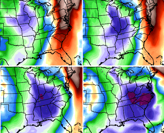
That’s how you wind up with warmer anomalies across the northern part of the country, with colder anomalies farther south and east.
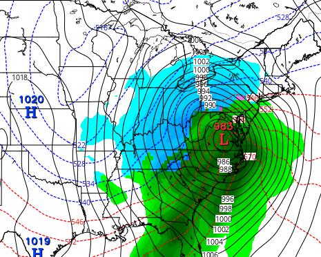
Transitions like that lead to the models showing winter storms from time to time. The GFS…
I’ll have another update later tonight. Enjoy the evening and take care.

Now that would.be a nice storm! But I won’t get my hopes up lol
I,m liking the warmer weather, especially since my heating unit has quit and the only way I can use it is emergency heat and I can’t afford that. So I am hoping it stays warm. That is not like me because I love a good snowstorm. Have great weekend everyone.
Rodger likes the looks of that last map! Bring it on!
Yeah Rodger, that last map would be perfect for a significant snow storm with that low in the Virginias–wishful thinking for now…