Good evening, folks. Clouds are rolling in ahead of an upper level system set to bring some chilly showers for Monday. Another one follows later in the week, but I want to focus on what could become a wild storm system next weekend.
The models continue to indicate a potent storm sweeping across our region next weekend into early the following week. Let’s use the European Model to illustrate the possibilities…

That type of setup would bring in VERY mild temps ahead of it…

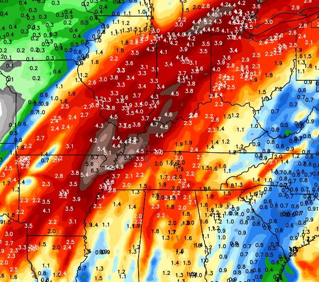
There’s also the possibility of some strong thunderstorms and very heavy rain numbers as the storm passes through…
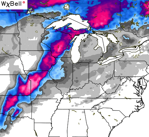
Once the storm passes by, temps would crash with the possibility of some snowflakes flying. That same run of the European Model has a swath of snow to the left of the track of the low…

The GFS from earlier today has a more wrapped up storm a bit farther west than the European Model. It still brings in some flakes behind that system as the temps crash…
This is the storm that tries to kick off a change to the overall pattern across the region. The models all follow that up with another system that could bring more of a true winter look to it.
We have a lot to track in the coming weeks.
Enjoy your evening and take care.

This may be the first time I’ve not seen anyone comment on anything all day. May been a glitch in system.
It’s that time year, on my on this day app on facebook, for last 2 days, I posted in in 2013 and 2014 about thunder and lighting with Temps in 35 in 2014 and 40 degrees in 2013.
Look forward to some cool seasonal temps. Sounds like fun times of tracking is in store next several weeks.