Good Tuesday, everyone. Our gloomy work week rolls on with weak upper level systems bringing clouds and the occasional shower chance our way. This weather is tame in comparison to the storm system trying to come together for the upcoming weekend. Buckle up for a windy and wild ride.
Between now and then, we have two more shower makers zipping across our part of the world. The first arrives Wednesday with some light showers. The next comes Friday as much milder air surges in ahead of our weekend storm system.
The forecast models continue to deviate a little bit on how to handle such a potent system. The European Model has been leading the charge with this thing for the past several days. It continues to show a powerhouse of a storm working into the Ohio Valley with near record warm temps ahead of it…
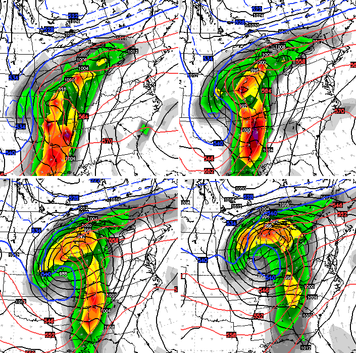
If accurate, strong storms and very heavy rains would be possible across much of our region. The high wind threat continues to show up, as well.
The Canadian Model shows this storm working right on top of us…
That track could also bring strong storms, heavy rain and high winds our way.
The GFS gives us a different look each time it runs and appears to be focusing too much energy on the northern branch of the jet stream…
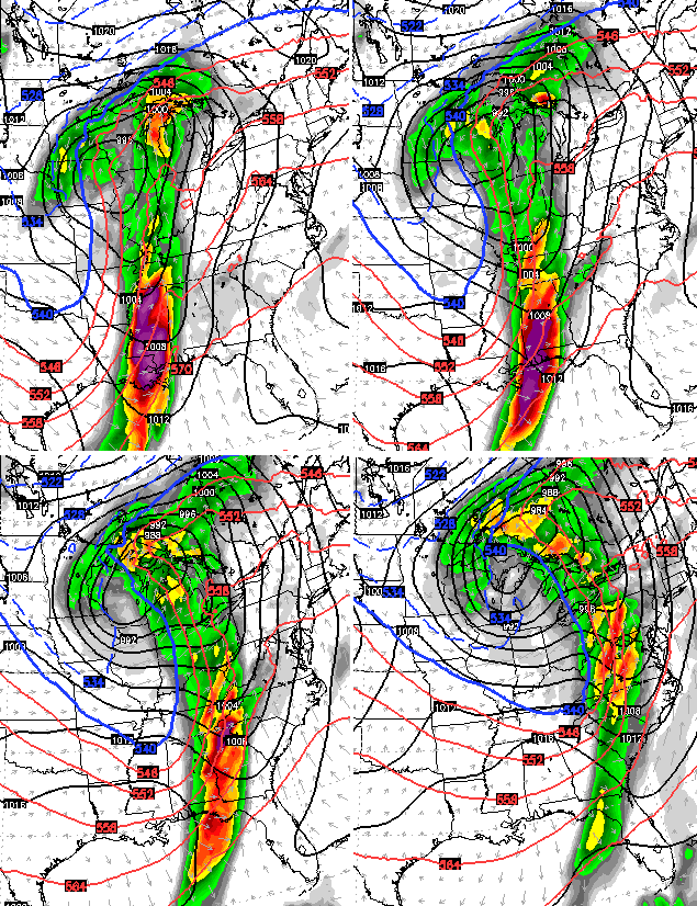
Whatever the scenario, a big temp crash follows as the storm passes to our north and east. It’s possible to get a snowflake on the wraparound action to start the new week.
That new week should feature much more of a winter looking pattern across the country. I will get more into that over the next few days, but I need to focus in on how the weekend storm plays out.
Another update or two comes your way later, so check back. Enjoy the day and take care.

Until this west to east storm track changes I just don’t see any winter weather it’s Pacific air and that’s not cold air. Weekend air temps could get close to 70 both Saturday and Sunday (record warmth territory) Once the storm system pulls out temps will drop 20 degrees by Monday. Highs around 50 that’s the normal high for this time of year and that’s by no means a big deal temp wise.
agreed….
It may very well be like 97-98′ when there was nothing for 3 months and then bam, a monster snow dumps 1 to 2 feet of snow….winter over!
Sad to see we are hanging on to getting excited about seeing a flake or two fly on wraparounds.
If anyone is hoping for a white Christmas, they may want to go way north or to the rocky mountains.
There is still chance for a white Christmas, albeit a small one, but a chance nonetheless.
Yeah, the GFS has been terribly inaccurate all year long and may not be the best indicator of a pattern change in a few weeks. If all the models start coming together on an agreement along with some blocking in the Northwest and far Northeast, then I am there for some winter weather partying…
I believe that storm C-Biv is talking about happen in January or February of 1998 and completely unexpected storm. If memory serves me correctly a piece of that storm got cut off from the main low and just sat over the Ohio Valley. That storm was supposed to be a Appalachian Mtn storm and points east only grazing north central KY and points west. Well that didn’t happen it gave most of not all of Kentucky a very good thumping that storm if memory serves me correctly snow itself out in Kentucky. Not before throwing Atlantic moisture over the mountains as far west as Missouri and giving KY 1-2 feet of snow that fell in a 3 day time span. It snowed constantly in some parts of KY for nearly 72 hrs if not longer pretty much light to moderate snow the whole event. It’s really the only snow kentucky got that winter other than that it was a fairly mild and quiet winter.
Certainly, we will end up with a very wet, above average precipitation total for December if we stay in this current pattern. I am right at 3 inches for the month here in Harlan, so I will go out on a limb without much fear of being wrong and say that December will end up above average precipitation and temperatures state wide:)
The weather could be very interesting this coming weekend. Typical weather for the ohio valley. Bring on the snow.
Embrace the warmth..Heating bills lower..Really don’t see a pattern change unless it rolls around the middle of Jan..
I just received a November heating/air bill under $100:) I am not complaining about that for sure, but will (MAYBE) miss a good snowy winter this year unlike those we have been getting more accustomed to over the past few years!!!
I would like to see some snow for the holiday period at the end of the month. Then after that I don’t care soon much. But I think the white Christmas chances are lower right now than in most years and our chances aren’t that good to start with. I guess the old saying misery loves company is true this year since only the high mountains of the West have any snow. We have a lot of company this year. This is going to be a tough pattern break. AccuWeather already has the warm air coming back next week after a brief 2 fray cool down.
Bright and sunny and in the 50s here in knott co.
I love it on here – a few warm days in December, and everyone’s packing it in for the winter…yep…blowtorch…nothing to see here…move along… 🙂
All kidding aside, though, it wouldn’t surprise me if March ended up with a colder average temperature than Decmeber this year.
Yeah, there are several people that are “canceling” winter this year because of the warm temps so far.
I agree with this statement, and the opposite will occur if we end up getting only one good winter storm in either February or March–everyone will think it was a bad winter even if 80 out of the 90 something odd days were warm…
I’m not throwing the towel on winter this early but until this pattern were in changes there won’t be much of a winter feel or look. Hopefully early to mid January will get into a true winter weather pattern.