Good evening, folks. I wanted to drop by for a quick update on the system rolling our way for the weekend. Overall, my thoughts on the possibilities with this storm have not changed.
The models are still showing some differences, but that’s to be expected with so much energy showing up. The GFS is looking much more reasonable with the storm…
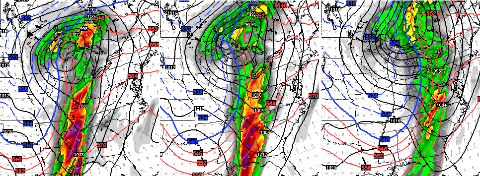 That’s from the 12z run and the 18z run looks even better, but I didn’t have the chance to put it on here for you guys to see.
The Canadian Model basically matched what the GFS is now seeing. The European appears to be dragging its feet a bit with the energy coming in from the southwest…
 That leads to a slower arriving system that’s more detached from the main flow. That’s one of the biases of that model with southwestern energy. Still… the overall impact isn’t that different.
What is that impact?
– Near record high temps on a strong southerly wind flow Saturday into early Sunday.
– Rain and a few strong storms increase from west to east Sunday.
– High winds will be possible Sunday into Monday.
– Temps crash into Monday and there’s an outside shot of a wraparound snowflake or two.
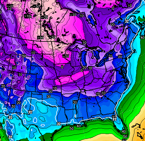
The models continue to advertise much more of a winter looking pattern over the next few weeks. The GFS, yes I know it’s the GFS, continues to crank out deepening troughs digging in…
 That really deepens as we inch toward Christmas…
 And for fun… the GFS temps for Christmas eve…
 As always… we shall see.
Make it a great evening and take care.

If the GFS (BIG IF AT THIS POINT) would come true with the freezing line all the way to ocean and strong southern jet, I would expect the ground could be a little white around here to end the year!!!
I hope you’re feeling is right!
Christmas would be a perfect time for this pattern to turn around. I’m trying my best as a snow lover to hang on and tolerate this pattern right now. Hoping January and February feed my snow needs! I’m like CB…by March, I’m ready for spring!
Bring on the Polar Express!
Love to see a big snow on Christmas!!