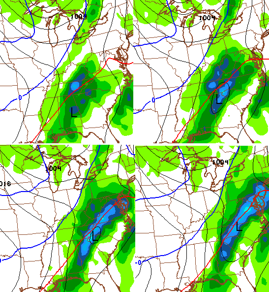
Good Monday, everyone. The winds of change are cranking across the commonwealth of Kentucky today. These winds could cause some issues as they blow a swath of rain across the state. All of this ushers in some big changes later this week. Changes that will make it feel like December… Finally!
Winds today are the big issue. Gusts of 40-50mph will be common with higher gusts a good bet… Especially during the first part of the day. That shield of rain sweeps eastward with a few showers lingering later this afternoon and evening…

Temps continue to run above normal through Wednesday. That’s when a strong cold front arrives with the coldest air since last March behind it. That front swings in here into early Thursday with falling temps as the day wears on. A wave of low pressure still looks to develop along this front. The GFS has a close call for winter weather from it…
The cold air really pours in behind this system on Friday and Saturday and should be accompanied by some snow showers and flurries…
That sets the stage for a cold weekend with highs struggling to get to freezing on Saturday. Lows may hit the teens this weekend, but the Canadian Model is likely too cold…
The stage is already being set for what could be a crazy Christmas week of weather. Temps are going to go way up then way down and that could spell a lot of precipitation through the week. The GFS is juiced up…
Another update flies your way later today. Make it a magnificent Monday and take care.

More precip? You know, since I moved here in 1996, some of the wettest years on record have occurred MULTIPLE times.
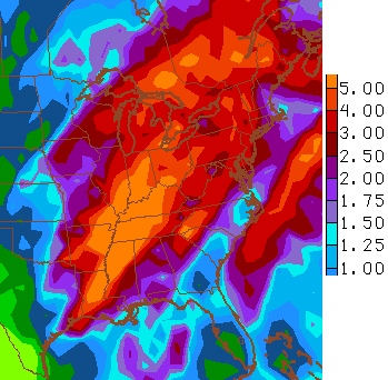
With this shield of rain, Louisville will enter the top ten rankings for Wettest Years on Record, accompanying other El Nino years or partial El Nino years that occupy at least half of the rankings.
Going back and reading the posts from the last 2 weeks, it seems like we had an abrupt change yesterday as to what to expect after the forthcoming cold front comes through. Before Sunday’s first post, it was continually being discussed in terms of “pattern shift”, etc. Suddenly, that perspecitive went poof and it’s now “wait, what, lol no, winter isn’t starting you guyz”. in terms of going forward until the end of the month.
Sooooo, what happened exactly to make all of the other posts not relevant all of a sudden? That would seem to have the makings of a cool post, where CB breaks down what had dramatically changed to the near term outlook; one of those rare education posts, which me and many people really love.
Yeah, yeah, the whole “winter is back loaded” deal is still on the table and that’s not what I’m talking about. I’m referring to how this coming cold event was discussed previously and the outlook for the middle to end of the month.
I would like an education post too LD.
Weather: Trying to predict the unpredictable.
The most interesting thing to me that Chris said back in the Fall when thinking about this Winter was there were no analog years showing up he could point to for the pattern. In addition to the traditional El Nino, most of the mid-Atlantic and mid-Pacific are blowtorch warm. In the 1997 El Nino, this was not the case–the mid-latitude Atlantic and Pacific water temps were normal to cool. Today, oceans are heated up almost planet-wide, and I’m not sure anyone has a handle on exactly what kind of pattern that will create. A lot of mid- and long-term forecasts may go down busted this year.
That’s exactly why I did not put out a season-long outlook. I am only dispensing my prediction one month at a time so I can keep up with El Nino’s influence. But, so far, the other Mets I follow have basically said no real winter until the second half.
I noticed the same thing LD. Perhaps he underestimated the strength of this warm air pattern and how tough it will be to reverse it. Or maybe he was trying to give those of us hoping for Christmas snow something to hang on to. That being said, I think we have a whole lot more 50 and 60 degree weather to look forward to.
I was thinking the same thing about the last few weeks pointing towards this front today as a shift in the pattern …but not so much now …but I wasn’t gonna say it bc I like commenting here lol
The neighborhood just across from mine is now without power due to high winds…approximately 214 LGE customers. Nearby Fairdale has over 2,000 customers affected. Countywide, as I write this, some 4,600 affected customers has now been reduced to 2,700.
This December so far has been blowtorch, and it isn`t looking too promising in the short term. I hope everyone is dreaming of a warm Christmas. 🙂 …..but it will get colder “the week after next.”
Now that El Nino has hit its stride and begin to ease somewhat. I wonder later part of winter will come out like a lion
I don’t really see a winter at all this year.
My bold prediction for 70 & storms somewhere in Kentucky in January is still on the table. I do wish we could squeeze out some white stuff for Christmas.
Well….. all I can say it IS Kentucky after all!!