Good evening, friends and neighbors. Our current storm system is slowly pulling away with better weather coming up for the next few days. That changes later this week as some real deal December air moves our way. Will that continue into Christmas week?
A cold front arrives late Wednesday and that allows for temps to spike ahead of it. Showers move in late in the day with winds increasing, too. A wave of low pressure develops along the front with a cold rain into Thursday morning. Temps Thursday then drop as the day wears on and a few flurries could fly by the evening.
A northwesterly flow is likely to give us some flurries or out and out snow showers on Friday…
 The GFS even tries to indicate an evening rooftop dusting…
 Friday into Saturday are cold with wind chills coming into play. That begins to pull away later Sunday into early next week as rain quickly arrives Monday. This will be a system ahead of what may turn out to be a HUGE storm from Wednesday through Christmas Day. It’s one that can give us a lot of wind and rain, and the potential for a switch to winter weather behind it…
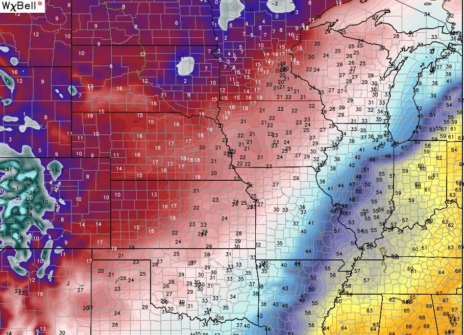
 The temps associated with this storm could be pretty awesome to track. We could spike back into the 60s ahead of this thing with VERY cold air diving in behind it. Check out this map from the GFS to start Christmas Eve Day…
 Like I said… that’s awesome to see!
The models continue to indicate a very active southern branch of the jet stream over the next few weeks. Look at the GFS rain forecast…
 I leave you with the radars to track any leftover shower action…

Enjoy the evening and take care.

No 60’s on Christmas Eve is not awesome it’s heartbreaking
Rodger couldn’t agree more, Marsha. He’s seen NOTHING this early “winter” that is anywhere near awesome. Rodger in Dodger!
I thought it was trending colder, but now it seems like a warm Christmas is predicted. My household is ready for snow.
I got my snow fix for a couple of years, so I’m OK with this……..but I may not be able to go longer than that.
Wow this is actually really sad. Global warming at its finest
Keep on believing that “science”.
White Xmas for Louisville happens once In a blue moon. Any snow we receive in December is bonus snow. Waiting for a cold and snowy back end of winter.
Yea we typically get most of our accumulating snows late Feb-early Mar.But I was hoping to have more of white Xmas this year with that “snowy and cold” forecast that now appears to be heading in the null and void folder.
Ummm… I assume you’re not talking about my forecast, because that’s not even close to what I said.
I missed a few posts. Could you update on your forecast for Christmas /end of year, and your thoughts on what a very strong El Ninő means for KY this winter. I looked arba previous post that said look for cold around Christmas, but did not say snow. Thanks.
Yea, we get most of our major snows in late Feb-early Mar. Was really hoping to have one of those rare white Xmas around here based on the December forecast last month, still waiting for the snow and cold we have a few weeks left.
Here in Bowling Green were still waiting for the first flakes…… sigh…..:(
🙁
Chris please don’t bring out the white christmas meter that will just depress us snow lovers more then we already are