Good evening, folks. It’s finally cold outside, even it is only a seasonal brand of cold that continues for a few more days. Beyond this… we track three weather systems set to impact our region Christmas week through the weekend. Oh yea… It’s going to get a little warm, again.
Tomorrow’s flow is a cold one that can produce a few snow flurries across parts of the region…
That chill reaches all the way into the deep south, but doesn’t have any staying power. Temps slowly come back up later this weekend ahead of a rain maker Sunday night and Monday…

That keeps our temps above normal into Tuesday as we await the next storm system. That works in here Wednesday and Thursday (Christmas Eve). Temps ahead of this spike as rains increase…

The Canadian and GFS models try to bring a quick-hitting shot of chill behind that for Christmas Eve and Morning. Even if that’s real, it’s not going to hold. Another BIG plains storm system develops and puts us back into a southwesterly wind flow. That should cause temps to surge in the days just after Christmas. Records again? That depends on the progression of that storm. The slower it is, the warmer we get.
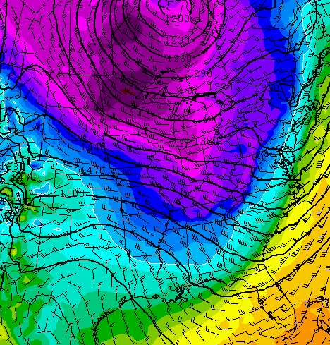
It may also blow in here with heavy rain, high winds and some thunder. Runs of the Canadian and GFS have shown cold air barreling in behind that departing storm. Here’s the Canadian for NEXT Sunday…

Enjoy the rest of your “cold” evening and take care.

Buck up Chris! You sound down. We’ll get past this warm period and maybe pull off some real cold and snow in the new year?
Thanks for keeping on!
Tonight I am pretty sure that ABC is going to air the Dr. Seus movie ” How the El Nino stole our white Christmas.”
Lol. I want to see the Jim Carrey version of that one to!
Ok bloggers see you after the first of the year when hopefully this warm crap will be over
I wouldn’t hold my breath. It’s going to to be a warm, rainy, dark winter. Sure we will get some snow behind the many warm rainy fronts but it is what it is. : (
Looks like mr Tony C on wsaz might just have been right about a snowless winter and a very mild one
Let’s hope the weather is colder than what has been forecast when christmas arrives. Rather have snow but don’t want record warmth on the 25th.
I disagree LOL! bring on the blowtorch….let s enjoy the warmth of this strange Winter 😀
And enjoy cheap heat bills…..maybe even cheap AC bills lol
I agree! My bones like these temps much more than cold! And that makes me happy!!