Good Friday to one and all. The pattern taking shape for the next few weeks is a very interesting one that can produce a lot of rain across our part of the world. That includes our Christmas week that has the look of wet instead of white. Let’s get into this wet and mainly mild setup.
At least we have the seasonal cold we have out there today. The cold may also be accompanied by a few flurries fluttering by the skies of central and eastern Kentucky. The best chance is in the north and east, and those spots may even see a true snow shower or two.

Saturday features sunny skies with upper 30s to around 40 in the east with the 40s returning to the west. Temps continue to climb on Sunday as clouds filter in by afternoon. Those clouds will put down some rain across our region Sunday night and Monday. Locally heavy downpours will be possible.
The next system the develops across the plains and pushes very mild air in here for Wednesday and early Thursday. Highs could reach the 60s before falling behind the departing Christmas eve storm. Rain is likely during this time.
Here’s what the same model run shows for Christmas morning…
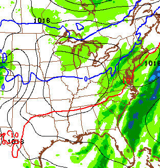 That’s basically a calm day with 30s when Santa rides into town.
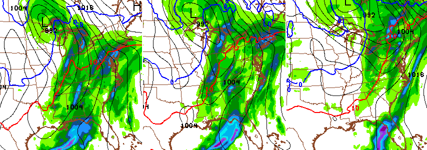
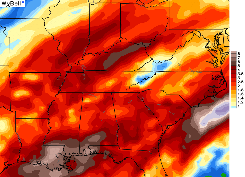
Things quickly turn crazy as we get just past Christmas into the weekend. Temps are going to initially surge as a big storm system develops across the plains and slowly works our way. The latest runs of the Canadian and GFS continue to mirror one another with a healthy temperature gradient and plenty of heavy rain. Here’s the GFS setup…
Temps swing back and forth along that temperature gradient, but that run shows us on the cool side of the boundary next weekend…
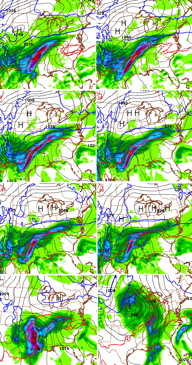
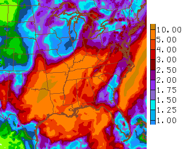
That’s Saturday afternoon on the top with Sunday afternoon on the bottom. The Canadian shows the same healthy gradient…

If that kind of gradient does setup… if… that’s how you get cold season flood events in our part of the world. Indeed, the Canadian shows some 5″+ amounts on this latest run…
The GFS through the next two weeks…
The European Ensembles for the next month is all over a busy pattern continuing…
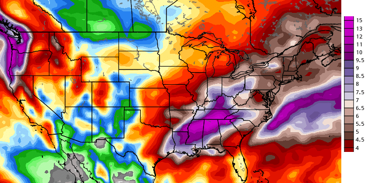
That’s an Ensemble average of precipitation totals and that’s impressive!
All that Ohio Valley stuff is very atypical of a strong or super El Nino… but this is no typical El Nino. It’s in a class all its own, so let’s see what crazy stuff it throws us before it totally collapses in a few short months.
I will have another update later today. Make it a good one and take care.

I was reading on accuweather.com a few weeks ago it had us in the 50’s and 60’s all the way through almost most of januray I thought these people was crazy we’ll I guess the joke was on me looks like they may have been right I really hate this weather
Is there a chance we will get any snow this winter at all? I mean measurable snow, lol.
This is beyond depressing! Rodger in Dodger
First flakes of the season today in Bowling Green!!! 🙂 🙂 🙂
What your seeing is pollen in the air not flurries due to the unusual warm weather. J\K lol
I knew it was to good to be true… 🙂
Frowning forecast! No one wants a warm winter. When I first heard someone mention a warm Christmas and December about 4 weeks ago, I refused to believe, but now–:(. Thankful for this honest up to date blog.
Why is it, that when the pattern looks to change to cold & perhaps snowy we get an abrupt about face back to the patter of warm & rain, but when the pattern calls for warm temps & rain for the next month…that pattern rarely flops to the other side??
No big snows expected this winter. How depressing. Maybe next year????
The last two winters were cold enough to kill the hydrangeas back to the ground (which means no blooms the following spring). So far, this fall/winter has been a nice reprieve. I’ll take 40s and rain. Of course if nature wants to give us 50s or 60s instead, I won’t complain.
So much for that “pattern will take on a much more wintry look after mid December.” Anyone who thinks El Nino isn’t the driving force behind what may be a historically warm December is kidding themselves.
I smell what you’re cooking
All is not lost..Ensembles hinting at maybe something better 1st,2nd week of Jan..Guess we’ll have to wait and see if there sniffing out a change..Have a feeling we may not L,ICE what’s coming..
Here in Wayne county it snow flurried all day. This evening around 6 it snowed hard and sleeted and coated the roads making driving difficult.
Tried to enjoy it while it lasted as it might be the only snow we see all season!
Snowing in Pikeville covered the car.