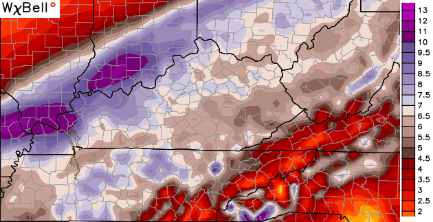
Good evening, folks. Rounds of heavy rain and mild temperatures are on the way over the next week and change. This heavy rain signal is a VERY strong one that could set the stage for high water issues before all is said and done.
Showers return from west to east later tonight into Monday. Track the action in from the west…

Showers and some thunder increase Monday night into Tuesday as a stronger storm system takes shape. This will pull up very mild air through early Thursday, with highs in the 60s. Heavy rains are a good bet during this time…

The simulated radar from the NAM indicates some possible convection Wednesday night…

That action likely scoots through here with some cooler air coming in for Christmas Eve.
Clouds quickly return on Christmas Day as another surge of very mild air pushes in. That’s likely to be accompanied by more in the way of heavy rain and some thunder. This continues to have the look of a flood event across the Ohio and Tennessee River Valleys. The forecast models continue to spit out some ugly rainfall numbers over the next week…
Some of the computer forecast models continue to try and take on a winter look at the end of our storm. This morning’s run of the GFS has a potent storm system taking more of a southern track from next Sunday into early the following week…

Similar to what a recent run of the European Model was showing, that potent system helps create its own cold air on the backside of the low leading to some snow…
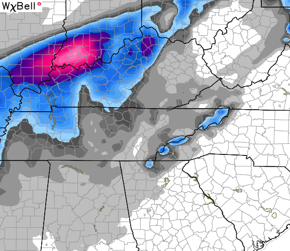
I think still think that’s likely an outlier solution, but it’s a solution that has now shown up on more than one model. That said… cool would that be to go from a flood threat and record highs to snow in a day’s time? That actually might be something to help us out if this system continues to look like a high water maker.
I will have a full update later tonight. Enjoy the evening and take care.

18z GFS run wants to put some wintry precipitation next Sunday hmmmm….. ok I’m intrigued not convinced but intrigued.
I do remember back in early 80″ s it was warm and had lot of rain falling then tem.PS drop below during daytime and all of sudden we had 10 inches on ground before nite fall. Anything is possible
Oops meant temps drop below freezing and had 10 inches snow on ground
Chris I’m ready for some snow!!
“…cool would that be to go from a flood threat and record highs to snow in a day’s time?” O.o
Yeah, if you have to work outside for your living, not really so cool.