Happy New Year, everyone. Here’s hoping 2016 brings you nothing but happiness… And all the weather you can handle. 🙂 With the coming of a new year comes a brand new pattern that has flipped to one we should be seeing this time of year. This flip is threatening to go to the extreme by week two of the new year.
A seasonal brand of cold continues today and into the weekend as skies slowly clear up. Winds are going to become gusty this weekend. ahead of a very cold push of air moving in for Monday and Tuesday…
With the water temps in the Great Lakes running much above normal… snow showers and squalls will try to fire up across Kentucky. Those plumes are already showing up on the models…

I doubt the models will be able to fully grasp just how warm those waters are and will likely underplay the flakes potential. That’s assuming the air is indeed as cold as they are showing. Don’t be surprised if light accumulations occur Monday into early Tuesday across central and eastern Kentucky.
Temps by Tuesday morning should drop deep into the teens…

Those numbers may grow colder the closer we get. Winds will be very gusty during this time. Check out the wind chill forecast…

That eases off by the end of next week as the southern storm track cranks up. One system may come our way with some rain or a mix during this time, but the big show may follow that up. Arctic air is likely to dive into the country and spread east into our region during the second week of the month. Can we get a big storm to usher in this very cold pattern?
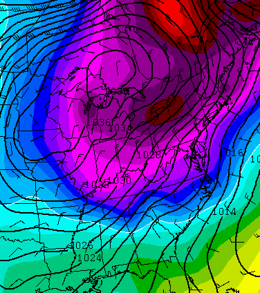
Odds favor some kind of storm across the eastern part of the country, and the GFS keeps showing it…

This kind of setup…

Can lead to some significant winter weather events across the county as we roll forward.
I will update later. Happy New Year and take care.

Thanks Chris. Happy New Year to you and your family and all of my weather friends. I guess it took a new year to get a wi tee weather pattern rolling. It’s time though. So much illness due to crazy temps! Just not normal for shorts and flips in December in Kentucky. Payback looks to be coming. Have a great start to 2016 everyone and enjoy yourself no matter what you are doing today! HAPPY NEW YEAR!!
Happy New Year Chris and all my weather friends.I hope it is the best year ever.May you get snow in your backyard in 2016.
I am actually looking forward to the WAS (week away storm) 🙂
I, for one really hope this storm materializes.
ME 2!
The two big snows have still left me full, so no harm no foul if we get nothing this winter. That said, if I had younger kids (and no huge driveway with to dig out, my perspective would be different.
Thanks for the update, Chris. I’m looking forward to a winter flip.
Time for a little snow. I’ll take even a little at this point.
Happy New Year to all!
Go Big Blue
How fitting that a new year bring a new pattern. I know a lot of people will be following the blow closest this week on the latest developments for the following week. Hoping January 2016 feeds Kentucky snow lover’s appetites like myself!
Thanks Chris for all you do to keep us informed. Happy New Year to you and your family.
I say bring it on!!! I’m definitely tired of the sinus infections and migraines that have come along with this weather and would gladly bid them farewell until springtime in exchange for some snow!
After a long delay, perhaps the Roscoe P. “Coldtrain” is finally about to leave the station!
RIP James Best (1926-2015)