Good evening, gang. A push of cold air is currently surging southward into the bluegrass state and will cause snow showers and squalls to increase into Monday. While this happens, it’s all eyes on the second week of the month and a round of potential harsh winter weather.
There’s not a lot more I can say about the snow showers, squalls and flurries coming in late tonight through Monday night. This action is centered across central and eastern Kentucky with the potential for light accumulations. The models show the areas with the best chance at coatings to local 1″ amounts…
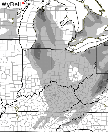
You can CLEARLY see the Lake Michigan connection showing up. I still suspect the models are underplaying the warm waters and therefore underplaying the activity we see around here. Reduced visibilities and slick spots will impact some drivers on Monday.
The models are still trying to sort through all the action showing up from late this week into the following week. It looks like one system moves in later this week with mainly rain. Colder air comes in behind that system as the next storm develops in the Gulf and lifts to the northeast. The models change from run to run on that system, so don’t take any solution to heart. It’s important to just to see if the models continue to advertise something.
The current Euro late next weekend…

The European Ensembles mean is farther east with the track…

The European continues to show a huge arctic outbreak coming behind that, and is now much stronger with the arctic wave of low pressure…

That would be all kinds of fun… IF it were to verify.
The 6z run of the GFS developed that arctic wave into something bigger…
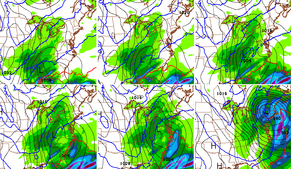
Moral of the story… there is a lot of potential during the second week of the month. Can any of it become a reality? That remains to be seen… But, I love seeing all this showing up during the same week I’ve been pointing to since Christmas.
Enjoy the rest of your evening and take care.

What time does snow arrive in southeastern Ky?
We got to get it first Chris hopefully we will get a good snow sometime
Hopeful for a NW shift on the big
Storm track next week and put
Ky in the middle of the
Bull’s eye!!
🙂
Thank you for all you do Chris!!!!
We sure do miss you here in Mingo County WV! We still follow your forecasts to know what’s headed our way. Keep up the great work!!!
Anybody else look at the 6z run of arctic wave and worry about the ‘I’ word? In plots #3 thru #5, the 540 line is uncomfortably close to central and eastern KY.
I see the freezing line down in TN through EKY and WV in all six panels. That would be all Snow for most of state.
I’m thinking mother nature is going to slam us with something major next week. I dread it but kind of excited about it at the same time lol
Hope whatever shows up , shoes up after the 12th. Normally I’d be all over it, sooner the better, but not this time. I’m ready to take a trip down south, hate to not be a leader get home on way back from my trip.
Bring on the snow. Weird weather no doubt. The super El Niño was hyped, but remember folks, measurable snows did not show up until late January last year. Which turned into a very memorable winter. Although it was a nightmare for many, including myself, it was memorable.