Good evening, everyone. The next winter storm moves our way late tomorrow night into Friday. This will likely bring significant amounts of snow to much of the region. Winds are also going to become an issue as the storm cranks just to our east.
I have no changes to my First Call map from earlier today…

That may change after looking at the 0z model runs, but I’m comfortable with where things stand at the moment.
The late day GFS looks a lot like that map, but with higher totals…

That same run is pointing toward a period of freezing rain early Friday across the south…
The SREF snowfall chances at exceeding set snowfall amounts…

Those are pretty high numbers considering that’s an ensemble average.
The WPC seems to follow along with those thoughts in terms of the snowfall risk areas. Here’s for Thursday night and Friday…

Friday Night and Saturday…

Again, those are impressive percentages.
Winds are going to be a big, big issue Friday into early Sunday. Gusts of 35mph will be possible and that would create blowing and drifting snow.
If the models are correct in putting down a deep snowpack, temps Saturday night would absolutely tank under a clearing sky. The GFS lows for Sunday morning…
I’ll have the usual late night update with a new call for snowfall. Enjoy the evening and take care.

Thanks
Getting real
So what is this business about the low following the edge of a snowpack? What’s this about? To think I’ve been following this blog from day 1 and I’m still learning.
Not sure that it is scientific. Just something people repeat.
Reals.
Cant wait to see the newest runs! Going to be interesting, no doubt. Thanks!
With the snowpack melting in Tennessee, I fully expect an influence in the track and a NW trend.
Well don’t know what happens tomorrow.. But I still got 2-3″ of snow .and I’m pretty far south
The snow pack is still alive and well here in South Central Kentucky.
What is the theory about the snowpack tracking a storm. If that was the case all the snowfall would fall in Michigan. If anybody can elaborate please feel free I am just interested.
I’m thinking it has more with people hoping for a NW shift than it does with actual science. Most all model data for the last couple of days has trended south and seem to be coming into fairly good agreement. At least more than we usually get.
the closer range models are actually shifting back NW. You will not see any more South shift. This close to an event, the GFS and EURO are difficult to use, too. You have to start focusing on the RPM, SREF, HRRR, etc…they do a better job under 36 hours.
The NAM and Hi-Res NAM hit today’s snow for my area on the head. I trust those models more than any in this time frame. Not saying a NW shift is impossible, but just think with all the data that has been collected since the storm came on shore and the agreement of all of the major models I think they should have a pretty good idea what is going to happen.
the RPM did a great job with Louisville 3-4″ an we got 3.7″.
In 24 hours, we will all see how this plays out.
You can tell you follow wave. You just said same thing Brian Goode said. Lol
very, true…BG and I go way back, lol.
And I agree with what he said 🙂
I wish someone would explain that to our local NWS office–their forecast discussion insists on downplaying all of this. Don’t get me wrong, I don’t mean to hype it up unnecessarily, but this is a BIG storm with lots of energy–it is what it is, and I think they need to at least mention the possibility that the storm track puts Charleston, WV right in the middle of the bullseye.
They keep insisting the track is staying south too, despite good model guidance showing it staying northwest.
when a fresh snow falls and a new snow storm comes behind it, many times, the Low likes to hug the edge of a snow pack.
Nashville lost all of its snow. So, right now the models are showing the L in SE Tennessee. Tomorrow it could shift to Nashville area. If it did that, there would be a significant difference in snow totals.
I don’t expect it to shift all the way to Nashville. However, I wouldn’t be surprised if it shifts somewhere into the middle. 50-70 mile difference is major.
But is that actually *caused* by the snowpack or is it just that storms in a row tend to follow the same path?
not the same path…the edge of the snow pack just happens to be where the snow still is from the most recent system.
Depending on how much snow melt there is, that can influence the following system.
Listen, ask CB, or BG, or MW….someone like that. They will tell you generally the same thing.
No they won’t. They know better. They went to school, they have common sense. In fact, they actually know what they’re talking about so no, they would not say “generally the same thing”.
It’s basically something like this. Low pressure systems are fed by warm air that does not not want to travel over cold. Take the path of least resistance. That is why travel around the edge of a snowpack.
Looking interesting…
Ugh.. Living in east tn.. Really puts you on the fence..I sure hope to get some of those totals on the backside..
NWS up here isn’t being very optimistic + we are currently sitting at 30 already
Thanks for the update. Am very eager to see the next update later and see what the thoughts are then.
I am confident that the storm going to move Northwest.
The 12z run should be interesting.
I regret that I cannot stay up until 2 a.m. to watch the European model.
Where do I look to see these models? Could you provide a link? Not that I will be up at 2 am. What have you seen that makes you think the storm will move nw?
To be honest Lucy anymore I let the readers on this blog give us the breakdown. Come back around 2200 or 10 o’clock and the viewers will give you a breakdown of the latest runs.
Also Chris Bailey tweets around that time will notify you about the run
Thank God! Finally SNOW! Early birthday present for me (Feb 2nd) hopefully it’ll snow more then. This hasn’t felt like Christmas or winter at all till now… It could stay like this year round and you wouldn’t hear me complain. I hate summer!
Totally agree with all of your thoughts and comments even down to your birthday. Happy Groundhog Day Birthday from one groundhog to another.
Same – I like spring, fall and winter more than I do summer. The only bad thing is winter here has so few days with sun, otherwise I love it.
Spring, Summer and Fall for me.
thats what i dont understand the map has my location athens ohio in the 5-12 with the 8-14 super close and yet intellicast and others say an 1”
No human input into those apps. It’s best to just stick with Chris on this one.
thanks
Hope things change because I don’t .50 of Ice…
if ur on Facebook come by Friends of Chris Bailey clay county chapter trying get memembership up!!! and visit Redneck bunker handicapping for horse stuff. I think ole Bailey Boy has this storm peg bout right!!!!
When do the next model runs come out?
School here called off for tomorrow. We may be out until Monday? Would love to see the jog to the NW! Thanks for all you do CB!
Same as you, I’m in the Highlands …hoping for the great northwest movement 🙂
I’m near Iroquois Park in south Metro. I think CB has it about as good as it’s going to get. LouMetro folks wants more snow. MikeS in Valley Station had about 3.5 inches and I had about 3.0
We had about the same….if the NW shift happens we may get more!
Southern Indiana here. We usually do well with this type of set up. I am confident we will see a NW trend. Think about how many times we have been on the southern edge of a storm and 12 hours out, it always goes NW and Indy steals our glory. This time we (Louisville area) are in the sweet spot should there be a NW move. Lots to watch in the next 36 hours. I hope all of Kentucky gets in on the Action.
My thinking is perfectly in line with your post. The models always bias towards the south in the initial runs and are rarely on the mark even 24 hours out. A NW jog would not surprise me in the least, especially if this low is as strong as they say it will be.
I agree Babs. New Nam looks good.
In other words, thousands will be without power Sat. Night as temps make a run at 0. Sounds wonderful!
Why even follow this blog with such a reply.
…… No cannibalism as well? Mediocre.
Doing a snow dance here in Northern Kentucky, really hoping for a shift for us to get big snow! Am I just dreaming….. Any chances?
It depends on where you are in Northern KY. There is always a chance.
I can see downtown Cincinnati from my kitchen window.
Lucky you!!
Why hasn’t the NWS issued a Winter Storm Warning. Although I am a Somerset Snow lover….this storm is making me very uneasy. In west Somerset, just eye balling the snow, it looks like 4+ inches, if we get ice then 8+ inch of snow…..to me that constitutes an emergency. Time to start talking about safety Issues. My husband is on dialysis, so maybe I’m just being overly concerned. Thanks, CHRIS BAILEY.
I agree good luck to you
Thanks… Crystal in Pikeville
Ok guys and gals, I’m in Carter Co (NEKY) and just curious as to all of your thoughts on potential snow amounts here. I’ve read what our awesome weather dude Chris has wrote, just looking for opinions and weather knowledge from all you awesome bloggers! 🙂
How much snow do you all think Huntington/Ashland gets? Thanks!
Thanks Chris. From reading the update, and the comments, I have come to the conclusion that it’s time to let our resident expert (meaning CB, of course) do the prognosticating and we’ll go with what he says. ChattyKathy, I agree with you, I don’t want ANY ice. But the threat is there. I am as antsy as anyone on here, but I will do my best to be patient. For those old enough to remember …… Get me outta here, Percy! Have a great evening all.
Thanks Coffeelady.
My husband and I are driving home from Disney World in the morning. Will we make it by the time this starts if we leave Florida at 5-6 am?
Onset of precip for many is between 6pm – midnight, depending on where you live. Drive safely.
Thanks! We live in Lexington. May try to leave around 4 or 5 am instead of 6 after seeing the new NAM on Chris’ blog.
We are headed to Nashville tomorrow night for work training. Looks like we are gonna be driving right underneath the storm
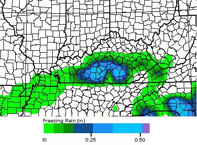
Seeing the .50″ freezing rain to be followed by 8-14″ snow. If wind really kicks up, Laurel County is shut down for a long while. Since we are roughly 24 hours from the onset of precipitation, shouldn’t we start seeing Winter Storm Warnings, Ice Storm Warnings, Blizzard Warnings, or something??? Not sure if folks in the “mix to snow” zone knows how crazy this could be. London Kroger sporting many empty shelves today. Hope a truck comes in overnight to serve everyone else who will be a bit late in hearing the news tomorrow. Be safe everyone!
I agree with you WeatherDadof2… Why hasn’t the NWS issued warning.
toniteNWS will update to warnings
Not that TWC is my reliable source AT ALL, but I noticed I-75 and points east is in the same color coding, snowfall and intensity categories as Northern Virginia, where a widespread 2 feet is forecasted….just saying. This could be interesting.
@Kentuckyweather: The new NAM through 30 hours looks much different than the 18z run. #kywx
Latest update from Brian Goode in Louisville:
“NAM update. Shifts from central AL location Friday AM to northern AL.”
CB tweeted about the new NAM…has a different look than 18z run. That’s too cryptic for me. I need the visual. Also need to know if we’re following the NAM in this timeframe? I can’t keep all the models and their timing shenanigans straight.
I think it moved north
CB with his cryptic tweets 😉 Mentioned the NAM 30 is much different from the 18. In what way?
He followed that up with a moderately less cryptic tweet:
NAM through 36 hours takes moisture father north than earlier. #kywx
😉
Chris – can u post a link to the new nam in the comments section? Or someone anyway? Thanks
I was just going to ask for the same. It’s killing me!
I agree, a link would be great!
http://www.tropicaltidbits.com/analysis/models/?model=namconus®ion=us&pkg=asnow&runtime=2016011900&fh=3&xpos=0&ypos=26
Ring link… Sorry. Here you go.http://www.tropicaltidbits.com/analysis/models/?model=namconus®ion=us&pkg=ref_frzn&runtime=2016012100&fh=42&xpos=0&ypos=0
I’ve been preaching that the NAM was having feedback issues. Now deformation zone of the snow according to the Nam is north central ky. lol
Thank you!
Check out Brian Goode’s blog. Need to look for Jan. 20th blog talk. Very informative!
http://blogs.wave3.com/weather_blog/2016/01/snowtalk-winter-storm-update-part-2.html#
“Heck of a snow hit for much of the state on the NAM. #kywx”
^^ CB’s latest tweet
What time does CB typically do his late night blog update?
Usually anywhere between midnight and three A.M.
“The NAM shows 1″-2″ of liquid equivalent precipitation across the entire state. Wow. #kywx”
“The NAM and Hi Res NAM both show a shutdown storm for Kentucky. #kywx”
Never give up on the northwest shift
☺️
Giveth and taketh and giveth and taketh and right now giveth.
So what does this new model run mean for SE KY?
From the NAM pic on Chris’ twitter, anywhere from 3-10 inches.
Can anyone tell me if the new model still has west liberty in heavy snow
this not good for the S/SE as ICESTORM looking very possible. the NW TREND l.ives as far as NAM goes
Bummer
Rolo what the new model run showing for west Liberty ice or snow
WINTER IS COMING
You know Chris is psyched when we get a flood of tweets after a model run. 😉
Wow! Could Lexington and much of Kentucky actually see another major double-digit shutdown snowstorm? Guys, if this pans out, please don’t bring back the word dome for central KY for the next 10 years please, and thank you.
Darth done left the building.
http://twitter.com/Kentuckyweather/status/690002959564931074
Long time listener…first time caller.
Hopefully link below will work 🙂
http://maps1.pivotalweather.com/models/nam/20160121/00Z/f57/acc10_1snowrv.png
here comes the NW trend…
http://twitter.com/Kentuckyweather/status/690002959564931074/photo/1
look at that….the low is wanting to hug the outer edge of the snow pack. NO WAY!
This is what nws jkl has for clay county
Thursday NightA chance of snow before 2am, then freezing rain likely, possibly mixed with snow between 2am and 4am, then snow, freezing rain, and sleet likely after 4am. Cloudy, with a low around 29. Northeast wind 3 to 5 mph. Chance of precipitation is 60%. New ice accumulation of around a 0.1 of an inch possible. New snow and sleet accumulation of less than a half inch possible.
FridaySnow, possibly mixed with freezing rain and sleet before 11am, then rain, possibly mixed with sleet. High near 35. Northeast wind around 8 mph. Chance of precipitation is 100%.
They are completely different from chris. They seem to be sticking to their guns on not much snow.
Wow…must not want to look at all the data that is available. I think this in a disservice to the folks in your area.
*is* a disservice, not in
so its may be looking better for me now in Athens Ohio for getting snow?
Looks that way. Bring the foot !
Nam drops the mic, lights the stage on fire, and walks off with it’s middle fingers in the air.
KWC comments section 6 hours ago- The NAM is the worst model in the world!
KWC comments section now- THE NAM IS MY HERO!
We will see I suppose. Maybe the NW shift is that strong.
CB I know you busy but please feel us folks here in the Charleston metro in. Local mets say warm wedge will give us about 6inches. What’s your thoughts?
Can anyone give any insight as to what sort of Icing potential we’re looking at for Lincoln county? I can live with a foot of snow more than a inch of ice, especially with children at home.
please keep moving away from Eastern ky.. I want to keep my power on
I agree, which ever way it needs to move please move away from Eastern Ky….
i wish this thing would go north or south of me but eitherway the nam is putting my area in the 1 foot range, not good for business
One item we have overlooked is the snow ratio. I am guessing a 14 to 1 ratio for the northern sections. I believe NAM is using a 10 to 1 ratio. Anyone know for sure?
Most models, if not all; use the 10:1 ratio.
That eye candy is like one of those sour patch candies for me. I wanted snow cream…I can buy ice cream at the store.
The northwest shift is alive and well! Still 24 hours to go and a handful of model runs but would seem much of KY and southern IN (hopefully) to get a BINGO! event. This is Rodger in Dodger
well if the NAM is right ur looking at even more NW TREND in thenext runs.
This!
There it went noto much snow for the south as expected
The most recent NAM cut my counties snow totals nearly in half….sigh.
Wow the NAM. That 16″-18″ over Nelson County. Holy crap.
Terrible run for SE and southern KY. Looks like dominant precip will be a cold rain to a change to snow late. If the trend continues, look for more of a heavy rain event for se ky and possibly areas like somerset, London and south. The dreaded 35 degree rain
Should have expected it. It’s the norm big system =rain more times than not
35 degree rain. Sir the nam showed an all out ice storm for southern ky with 6-8 inches snow
Will wait for GFS and even Euro at midnight to see what they look like. I have a feeling CB might be changing his snow total maps. Who the heck knows though by morning it could be tracking back up North along the river or south again! Sure is fun to watch!
Every other run of nam is back n forth. Hard to put much faith in it right now. 6z will be right back south. Nothing I don’t like is I’m in largest snowfall in half n 4-8 in others. Gfs n euro showing Floyd county in 14-18. New nam only possibly 4-6. No way that verifies. Not realizing the snowpack to keep warm air out
the 6z runs are always OFF runs.
Every 6&18 has been way more in line with Canadian hfs and euro ensembles. Bailey pointed out earlier that flaw of overdoing warm air on the nam. Hope it does extend more north for folks closer to northern lville but just don’t see us miss out when we have been right in the heart of the heaviest snow on basically every model for last three days. But I know what u mean about 6&18.
Eye candy is right from mr bailey. Just can’t see mid Sekt (Floyd/pike area) receiving anything under a foot
Heavy snows for north central and northeast KY, mostly rain for the parkways south. Look for Flood Watches if anything .
Your absolutely wrong
Send the snow across the ohio river, keep trending NW
From Chief Met. Kevin Harned in Louisville:
Big range over our area, but wouldn’t be surprised to see 10″+ for some, especially SE of Louisville.
Does this mean eastern KY is out of it for the heaviest snow???
Yup
Really??????????????
4-8 according to NAM still possible 17.4 inches for Lex, that what it spitting out. 7 for london
Done the same thing with 0z last night then all changed back again today. Might b a slight difference but not that much. No way it gets that warm in seky with what’s on the ground now
Already 30 it doesn’t have to warm much
19 in my area. Floyd co
21 here in Lexington
How much snow will central ky be getting anyone please
CB’s first call map will change a lot, going be a lot of disappointed people in Eastern ky and Southern Kentucky.. I noticed the people in the louisville and Indiana areas are rubbing it in..lol
GFS is now running…what will it show?
NW TREND
Yup pretty much
What about west Liberty prelude is this bad news for us
We look to get slammed here in Nelson County so far. We’ll see what the next runs show.
Noooooooooo!
“GFS goes the NAM route through 36 hours” CB
“GFS shuts it(the state) down, too.” CB
Looking good here for Ashland, KY on the GFS and NAM!
Gfs nails central ky, much of the state actually
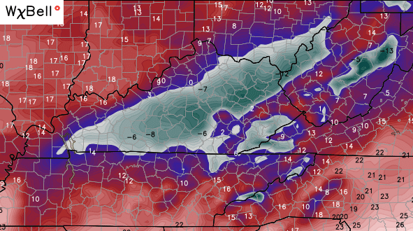
http://mag.ncep.noaa.gov/Image.php?fhr=042&image=data%2Fgfs%2F00%2Fgfs_namer_042_850_temp_mslp_precip.gif&model=gfs&area=namer¶m=850_temp_mslp_precip&group=Model+Guidance&preselected_formatted_cycle_date=20160121+00+UTC&imageSize=M&ps=model
Not a good look for SE KY. Cold rain, sleet, ice, and a late change to snow.
Sorry of our life here in this area.
Well look everybody take a picture the Nam & GFS are actually getting along and agreeing for once.
still 6-10 possible for LONDON area etc
I swear – this is so FREAKING stressful and I’m NOT even kidding!
NAM is shutdown and now Chris just tweeted GFS is the SAME!
I wish it would stop flip flopping.
And yes, please NO ONE EVER MENTION THE WORD DOME AGAIN!
I TOTALLY agree!!!!
How about the Thunderdome? Can we say that? No real reason on why it’s just a cool word.
But Maaaaark, I am your faaatherrrr!
http://maps1.pivotalweather.com/models/gfshires/20160121/00Z/f078/acc10_1snowrv.png
Was this the latest?
Should be. It’s the GFS 00Z run for accumulated snow thru Sunday w/ 10:1 ratio. Or for all I know it could be crop yield ratio for proposed hemp farms, lol. I just found the pivotal weather website tonight.
Glad you decided to start commenting. Appreciate witty posts.
Dag on it! There went my ft of snow in boyd co bet. 🙁
I think.you’ll fair well.with snow lol
Man, better stock up tomorrow if you haven’t already at least in the majority of the state if that NAM run is right. That’s a shutdown storm for sure which reminds me…I need more beer.
Went to Sam’s Club today in Louisville. Usually busy at 11:00. Besides the employees, there were less than 20 customers in the place. Good thing I went today than tomorrow!
The gfs has shutdown the internet also from noaa
“We are experiencing spikes in traffic that are leading to delays in downloading images from this site, especially when accessing the GFS model data. We expect to implement a solution to this issue by 1/27/2016. We appreciate your patience”
Some of you all whine and cry more then Coach K does for Duke!! Gee whiz it’s just snow people! Southern ky will get a deep swath of snow. And for those whining and crying near Louisville, settle down!! This storm is still gonna run on the East side of the Apps.
You’re just sour over people calling out your comment saying snowpack doesn’t have any bearing on the track of the low.
It doesn’t dude! Think about it, it’s gonna be almost 40 degrees tomorrow! Most of the “big” 3 inch snows from today will melt! So where will the snow pack be. I’d say mostly melted.
40 degrees if we get sun and that’s really iffy more like lower to mid 30’s.
Steve, you should have seen Chris’s updated snowfall map on WKYT just now…..Based on that, folks in Louisville will not be crying if they love snow…
Chris, that was kind of bold of you to put that up…..I HOPE we do not get that much snow……that’s as ridiculous as the last storms we had, but if you will remember it was 12 degrees during the majority of that event, a VERY cold powdery deep snow, if the daytime hi during this storm is just at freezing or upper 20s, it will be more heavy and wet…….not good.
Do you have a link?
Mark, I still don’t think it goes that far north west. There is gonna be a sharp cutoff somewhere along the river. The models will change tomorrow again! We go through this every year with these storms!
I wish we could get WKYT in Louisville…love to see Chris in action!
you can watch live online.
Thanks! I will check it out!!
When I had Bardstown Cable, we got CB @ noon & 5pm….then they switched to some stupid “local programming”…and now I have DISH….soooo much fun when it rains hard, the wind blows more than 25mph, or we get more than 6 flakes of snow & the whole shebang goes out….
Euro King will put an end to all this NW foolish talk..
I’m not seeing how Bailey is missing that the latest nam isn’t recognizing the high pressure. It completely ignored how strong the high pressure is and that will surpress the storm to the south just like the euro has noticed. Moved 100 miles from 18z. I wouldn’t put much into it.
Trent it’s interesting you mention that but Chris also said the new run of the GFS agrees with the NAM, so is the GFS not seeing the strong high pressure either?
Dt from wxrisk says the nam is bogus and he’s one of the best
Gfs is 30 miles further south than nam actually. Just looked at it
DT was talking about the NAM being bogus for the east coast.
It’s the same storm. Isn’t it? Lol
Yes, but completely different region.
What the storm does on east coast is what determines what we get because it’s the comma head deformation zone where we get our snow
How can a storm on the east coast determine what we will get if the storm is going to affect us first?
When the low transforms on east coast is why we get snow. If the low in Tennessee didn’t give away to the stronger low on east coast then the low in Tennessee would bring in too much warm air and no one will get snow.
When the low forms on east coast. The placement of that low determines how far northwest that comma head snow band reaches
don’t forget to join my facebook friends of Chris Bailey page, also join the Redneck Bunker Handicapping for horse talk.
Wow his snow map changed big time. 3-8 all the way up to Indy. 8-14 for Louisville
What bout nothing for Covington then they go to 5-12. Bailey is going by one run of the nam. Euro don’t support this. Nam is bad within 36 hours. Gfs has Covington 3 inches. I don’t understand it
The Euro isn’t even out yet so how could it agree or disagree with anything?
Were talking bout the one that ran earlier
CB this close in is not going to be shooting from the hip with models. This is game time for him 🙂
http://pbs.twimg.com/media/CZN0lwAWwAA7RnV.jpg
I can’t believe we have went from over a foot -18 inches to 5-8 inches after all day that’s all I heard from everyone every weather person I guess it just shows models are not very accurate.Yes I am whining
RPM MODEL has 1 inch in london 15 in lex..
That’s a very drastic change from first call to second call and right after one model run. Not Chris Bailey like
that’s now 5 models in close agreement, and the storm is on land. Sampling of the balloons has really helped with this.
GFS/NAM/GEM/RPM/SREF all relatively close now.
I tried preaching this earlier, but nobody was listening.
The gfs is 30 miles different than the nam. The nam showed 3 low pressures. Yes 3. How is that right
One of the local mets actually showed how this was correct. One low coming from northwest of Kentucky through Arkansas meeting up with a low around Louisiana then riding over the south and meeting up with a low somewhere in the Carolinas. That isn’t verbatim, and I’m not a weather geek, just a snow nerd.
Yes, it is 30 miles different. But, I said “generally”….meaning 5 separately run models are coming into a close enough range of agreement, that the MET’s are gaining confidence in placement of the bigger and smaller totals.
You are not considering the weight of the data in relation to time. The closer in and when actually on land as a system, the weight of data is with the most recent model runs. Convergence of the model solutions also helps, but not always the case.
I went from 8-14 to 3-8 lol
So now we know why Trent is mad.
Shutdown storm it just got real
Reals.
Hope the euro goes south, I need some encouragement after what just happened to my snow totals in SE ky
Crossing my fingers for that, too….
Me 3
Not happening you 3…sorry. 🙁
this storm is hugging the snow pack in Tennessee.
Well the snow here will melt tomorrow so I guess it will be a lakes cutter
LOL
they’re calling for 33 tomorrow here. Snow will still be around.
It follows close to the edge within the jet stream it is running on (which is the southern branch). So, no Lakes cutter my friend. NE flow won’t allow it either.
If the sun shines tomorrow I guarantee your snow will be gone
I’m not worried….snow will be on the ground in Louisville when the next snow arrives.
Me too Wildcat!
I am not trying to be smart just disappointed but Chris how could the models be so wrong or off with the snow accumulations totals and then one run changes everything I just don’t understand it I know it’s not your fault but wish you could explain it thanks for all you do.
In my opinion, Chris also agrees that the Northwest trend almost always wins and that’s why I feel he changed his numbers. I’m in the 8-14 inches so no complaints on my part lol.
It’s actually going back to what it was showing earlier.
I wouldn’t count the gefs.
Some need to leave the weather forecasting to Chris, it’s his blog, respect that please.
Won’t hurt my feelings if we don’t get ANY SNOW. Ain’t got time fuh dat.
I’m confused and don’t know what to think. I’ll wait and see I guess!
GFS ull was farther west and 2mb stronger..Throws more warmer air north..Just plain foolish saying a storm follows the snow track..lol
The fact that I’ve heard most MET’s talk about how the edge of a snow pack can influence the L sometimes, makes me think they must have all gotten together and made it folklore.
Secret society stuff, lol.
Well if that’s the case why have models..Just follow the snow pack..lol..What if tomorrow’s run shift back south..Was it because of the snow pack..If you look at the models you can see why shifted north..
it “can” be an influence…in this case, with the storm diving in on the southern branch (not northern) and the gulf moisture opening up to feed the low, coupled with a strong NE flow on northern stream, sometimes the L will guide near that new snow line, but, not always. It’s just something that has happened in certain setups. This, I believe, is one of those set ups. It’s not a rule, or exception, just a possibility in guidance.
Yawnnnn, someone say snow? All the hubub woke up this old timer to this site. 😀
Holy tug of war, people! Peace!
It shifts north, south freaks out….it shifts south, north freaks out. Its gonna dump where it dumps. Enjoy the ride. 🙂
Let’s have a war between the north and south lol but as far as snow is concerned we in the south do loose a lot to dry air warm air not holding our head right lol no air the dome
Guys I wouldn’t pay attention to any models until tomorrow night. They will continue to go back and forth right now.
NO ice is all I ask for here in my part of Knott County.
Hope for the euro to trend back south too or knott will end up seeing around 5 inches (or less). The nam underplayed the high pressure and gfs still has us in decent position for 6-10 but the northwest trend scares me. We have a snow pack going for us but that can only lower temps so much. The new midday runs tomorrow, if the euro remains, should be back to where they were today—dumping on Southern Kentucky.
How’s it gonna rain in southern ky? There predicting temps to be between 30-32 degrees Friday!! This is crazy! And thinking the low hugs s snowpack, well that’s crazy too.
So the 3 mets I’ve heard say the same thing today are all wrong?
What did they say?
Everybody needs to wait for the euro before jumping to conclusions. Yes the system is already real, but the exact track of the low is far from set in stone. The euro will show how the system will go. Chris knows what he’s doing, but I guarentee if the euro goes south, Mr. Bailey will have a new snowfall map.
….about the low & snowpack, I meant. Not challenging you or being snarky, just curious. Because its the one thing I have heard over and over again today from meteorologists discussions.
At those temps, if you get rain, it will freeze on contact with the ground; or whatever it hits.
Someone post the euro when it comes out.
Nws jkl. Just posted over a foot for my area. CB says 3-8. Guess nws hasn’t ate at the Waffle House tonight lol.
Yep, them there NWS folks have been spot on, specially the two big events last year. Not.
http://i.imgur.com/rum8rV4.gif
0z gefs
It shows the storm a bit more south.
Yes but at this point i guess it’s best to follow the op..Anyways really don’t care who gets what..Just snow.Lets see if the Euro follows the trend…
Ohh no that shows Louisville getting an ankle biter
I would hardly call 5-6 inches an ankle biter.
Ok maybe a miniature yorkie neck creeper lol
Has the Euro ran yet? Anyone have a link to it?
Bailey prob won’t tweet unless it aligns with his new map
Now you are being rude. Well, you were earlier, but now more so.
Me and u both know that’s true sir
New Canadian lil south and less moisture for everyone. Uhhh
did the Euro go south?
Euro looked the same to me..Maybe a little faster..
http://i.imgur.com/RrmpABt.png
Thank you for posting. I can go to bed now lol.
Ohh wow 1 inch for Louisville. This is a model battle
That’s further south than the last run
Euro vs us lol
It has support in placement from Canadian. Gefs.
Lol not sure I buy the euro. Takes 5 inch snows all the way down in Mississippi
Yes I think we have a winner with the NAM/GFS. I dont think Chris would’ve revised his numbers if he wasn’t confident those two models would call the storm.
Euro and gfs ensembles south. Oz gfs ensembles hammer Lexington south
Sorry trent buddy, cky gets the big one
Lexington is central KY???