Good afternoon, folks. What an absolutely gorgeous winter day we have going on out there. The sun shining off a deep snowpack is something straight out of a Christmas card. It all started with many areas seeing temps well below zero…

I wanted to drop by for a quick update on the week ahead of us.
A cold front moves in Monday night and Tuesday with some rain and snow showers. This front will then slow down just to our east late Tuesday as a wave of low pressure develops along it. You guys know I was riding the SREF model with this last storm and it really did well. That same model shows the precipitation shield fairly far west Tuesday night and Wednesday…
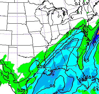
The new GFS shows some snow from this in southeastern Kentucky during the same time…
Snow showers then form behind that system across much of central and eastern Kentucky.
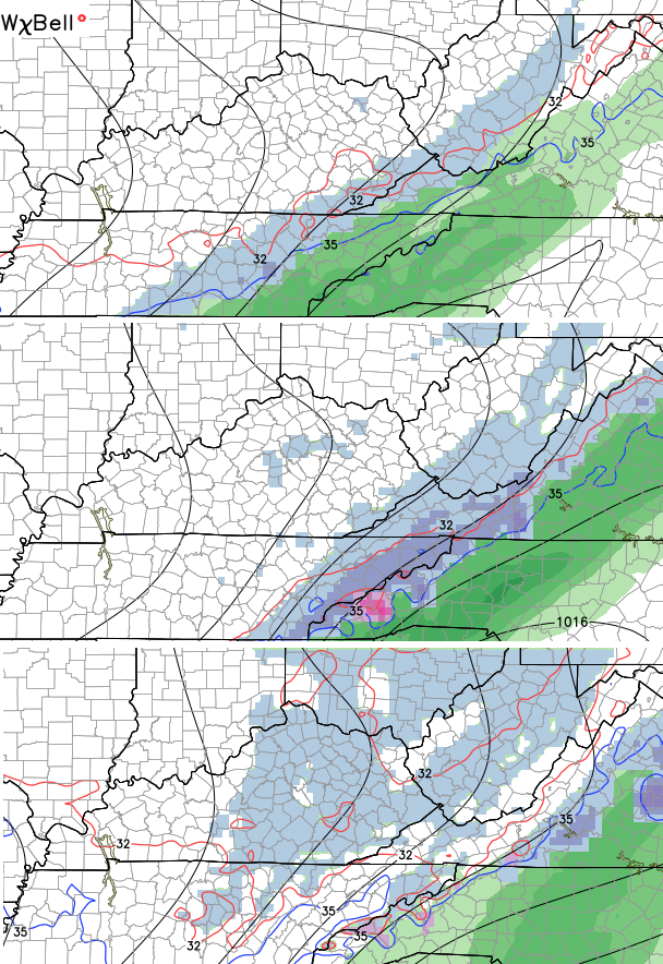
The models are also now going toward a clipper system dropping in here by Thursday and Friday. This is what the GFS shows…

The European Model has the clipper diving in and trying to pick up a big storm coming out of the Gulf of Mexico…

We have some potential for winter weather this week, so let’s sit back and watch how it all unfolds.
I will try to update things again this evening. Enjoy your Christmas Card of a day and take care.

Thanks for the updates! Hope you have a great day, too.
Thanks !!! Looks like it will be a while before we go back to school in Southern , KY.
This far out, a more North western trend could happen and give us rain or mix in Southern KY; therefore, I am not going to get too excited yet after being one of the losers from this past storm:(
I’m sorry, you can have some of ours. I think it’ll take a while before we can clear 12″. Rain would help!
I think rain could help here, 17 inches. But they have yet to clear the road, which is to be expected, and might create a mess. Imagine that snow getting packed down and those temps dropping to freezing overnight. Would pack this stuff hard. I would be stuck here for a long while if that happened.
Thanks Chris. You are right about a Christnas card kind of day. It is absolutely beautiful out there! Roads are treacherous so stY off of them unless it’s a have to! ( it was for me. Had to have a script I can’t miss.). Going to enjoy this beauty. Thanks for slam you do Chris. Hope you enjoy this day as well!
We had abt 12 inches of snow at my house just out of Flatwoods in Greenup Co. It was 3 deg this morn on my front porch! Thanks Chris for all u do!
The longer we hold this snow the closer we might get to another. I just hope that does not happen. But if that Tuesday night to Wednesday is cold enough and puts down a little more I would not be shocked. Would probably take the whole school week out of the picture. Then I wonder about next week.
Fun snow and a lot of it. I know winter is not over but I will be ready for a real nice warmup.
Thanks for the great heads up Chris.
Hopefully we will get some snow here in northern KY! Nothing from the big storm here in Boone County! I wanna build a snowman :)!
I know this blog has calmed down MAJORLY since the storm.
So, over the years, we complained about the dome in parts of KY, until pretty much every part of the state has gotten big snows so the dome is busted for most of the state….Which part of the state still has a dome, if any……and when was the last year you had a dome buster?
Another question. People talk about Indices in the weather world on here sometimes…What were/are the indices during this last storm? Like PNA, AO, El Nino (strong or weakening), all those things? Just curious.
And Chris, Thanks again
Awesome question on the indices. Would be very cool if Bailey did a quick post about that.
Overall, I think the dome busted last year in Harlan, but we have not officially broken 12 inches from anyone storm in the valley since the 90s. Last year, we had 11 inches from winter storm Pandora, but I actually recorded 18 inches at one on the ground after several storms hit in February without fully melting between events. So technically, parts of Harlan Co. have not had over a foot from a single storm, but we have had more than a foot on the ground from cumulative storms last year. Also, we had over a foot in places around my house where Wednesday’s storm did not melt off + the new 10 inches I received through Saturday evening.
I still want my 20 inch + snow, and I am not counting this winter out yet:)
Thanks for all the hard work you do to keep us informed about the weather! I check this site daily and check back for updates! I then inform all of my teacher friends the chances for snow! Lol
40 degrees here in neky! Beautiful day!
Great day with lots of thawing in Stanford, Danville and Crab Orchard.
“The overall pattern is likely to relax a bit over the next few weeks, but that doesn’t mean winter weather threats won’t be with us.”
Just two weeks ago, when everyone was bemoaning the lack of snow, it was said here to not fear that Feb would be the most active month. Originally, it was Jan and Feb, and Dec was going to be the slow month (slow and warm it was). So now Feb is no longer the super active month? Just trying to keep it straight going forward.
Lord knows I don’t want any more snow!
Weather gurus.. What is the clipper looking like for Thursday night? A dusting type snow, 1-3 inches?? Thoughts?
Bring me some more snow in Middlesboro. 🙂 6″ last Wednesday and 7″ Friday. I’m not greedy. I’ll take 6″ and run with it. Lol
lol, we got 3” Wednesday and 14” Friday-Saturday! Ha ha..i would take 10” more…I’m not greedy 😉
Thanks Chris for all you do!!!
Even though I live in Kentucky (12 minutes from Pikeville High School and 10 minutes from Pike County Central High School and 10 minutes from Belfry High School) all of the news stations I get are West Virginia stations…CBS, ABC, NBC, and Fox I receive are all based out of Huntington/Charleston 🙁 I really wish living in Kentucky I received WYMT/WKYT.
Your blog is the main source of information for me when it comes to local weather here in Eastern Kentucky, it is the first place I check every time i need to know about our local weather. You are hands down the best!!
Near louisville, we didn’t receive the predicted amount of snow. We had about 4 inches instead of 6 to 8. Looking for at least a foot of snow in the near future!!!
As someone mentioned above, is Feb still expected to be the MORE active winter weather month? Has CB addressed this recently?
Hopefully, as the week progresses and it warms up later with little rainfall amounts, this will help with a more controlled snowmelt instead of a heavy rain producer aggravating the snowmelt and leading to widespread flooding issues later.