Good Monday, everyone. The past week of no sleep has finally caught up with me, so I’m going to keep this post short and to the point. Of course, I always say that and end up getting on a roll and writing more than I intended. The things I do for you people. 🙂
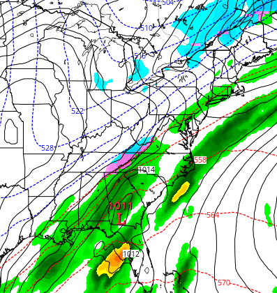
A cold front moves in here later tonight and Tuesday with a band of showers of rain and some snow. Winds will be rather gusty during this time. That front slows down late Tuesday with a low pressure trying to develop along this to our south and east. That has a shot to produce some light snow across southeastern Kentucky, but much of that looks to be just to our east…
 That’s what the Canadian Model is showing for Wednesday. The same model then follows that up with a clipper by late Thursday and Friday…
  That same model run brings fresh cold over the snowpack it says is still around and produces this…
  I’ve been riding the Canadian model temps this winter, and it’s been great, but I’m not buying that. Why? Because I think there is still a chance we have a big storm developing somewhere across the eastern part of the country. The latest European Model is still hinting at this…
 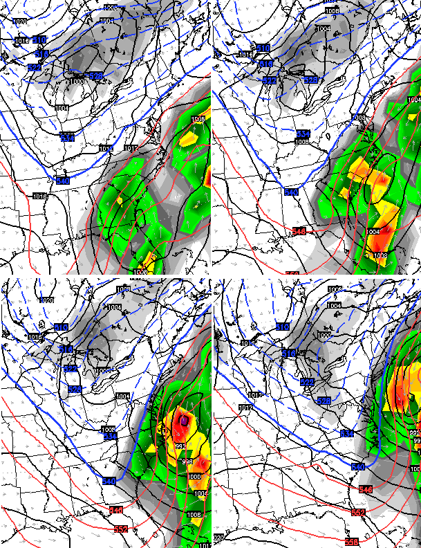 I still think the brutal pattern we’ve been in is going to take a break over the next week to ten days. That doesn’t mean we can’t have some winter during this time. The Canadian Model says this break doesn’t last very long and shows a couple of winter makers early next week…
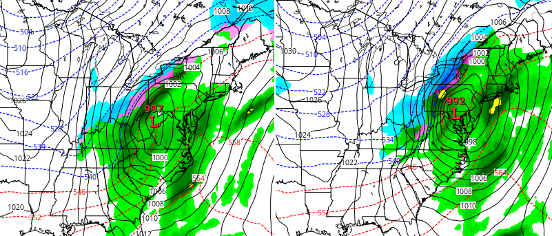
 Told ya I would end up writing and showing more than I wanted. I will have updates later today. Make It a great Monday and take care.

Rodger says BRING ON MORE SNOW! We’re just getting started! Rodger in Dodger
Thanks Chris. Rest up my man.
Rodger is right! Looking forward to some more snow.
I`m still looking for a big one to hit Shepherdsville. We received about 2 inches with this last storm.
Thank you for all you do and your sacrifice to your profession. I always thought I would love being in that profession and as a science teacher I admire you all. Now, get some rest. Spring is coming!!!!
I thought the deep snow pack would limit temperatures rising into the 40’s….does anyone remember Chris saying that?? I guess it would just be much warmer if there wasn’t a snowpack!
Already 37° in Richmond. Very nice.
my phone app for WKYT says uppers 50s and 60s for Saturday, Sunday, Monday and Tuesday; just wondering what are the chances if that actually happening ? warm up wasn’t even mentioned.
We had 101/2 inches of snow total and the main roads are in pretty good shape. Right now in neky we have 25 degrees under partly cloudy skies. Wouldn’t mind a warm up….just do not want ice or freezing rain. Ugh!
Nobody is calling for ice or freezing rain
We ain’t gonna get no more…trending warmer from here on out. Think the rest of the winter will be like our December praise the lord. No more snow for us, hope everyone enjoyed what they got! Let the great melt begin and pack away your winter boots and coats!!!
I dont see whathe says the european model is hinting at….he talking about another shut-down storm coming?
Hoping that the gradual warming and less rainfall will help with a more controlled snowmelt, as heavy rain producers would tend to diminish the snowpack too quickly and result in high water issues.
I see possibility of light rain. High of 42 then dropping off to 25. My road will be a sheet of ice. With all that snow and then refreezing of that stuff. Especially if Wednesday only gets to 34 like a lot of forecasts are saying.
Have to wonder about a lot of the side roads. The ones that have been scraped are going to be wet. Then you have the huge amount along the sides of the road. I could see a lot of icy roads Tuesday night into Wednesday and possibly Thursday.
Thelma Lou was very pleased with what we had over the weekend, but she’s ready for a break…if the next one can move in here on a weekend somewhere in February we’re all for it!
Bernie, you and Thelma Lou are not alone in your sentiments! 🙂
Temps was pushing 50 in Carrie of knott co for a time this afternoon.
Temps overachieving today despite the thick snow cover. Or should I say now rapidly shrinking snow cover. Mid to upper 40’s across most of the state. GFS nailed the warm temps today, while the NAM is about 10 degrees too cold with high temps. The models don’t take temps back below freezing until late tomorrow night.
I remember CB said Saturday night the temps would probably not get above freezing this week, but the margin is about 10 to 15 degrees warmer than expected. What changed?
I’m glad it will melt and thaw, since a lot of this pretty white snow gets kind of funky if sitting here for another week.
Hit 47 today at my place. I managed to get out of here and in town it was showing 54. Mesonet was at 51 not to long ago so temps were definitely above any forecast. Seems odd with the snow. How much effect does the snow have? Seems it should have some and I have seen it mentioned many places about the impact it has on keeping temperatures in check. Wonder what today would have been like without the snow then.
I wonder now if those other forecasts are on to something with temps. Wednesday most are around 34 here but after that most 40s all the way to 60’s soon. Guess we will see how that plays out.
Warm air advection is almost always under-estimated in the Ohio Valley, like it was today out ahead of the approaching cool front. Snow or no snow on the ground, southerly winds will always sky rocket temps.
Once again the blog comments bottom out after the storm.
Let’s enjoy our warm spell that’s coming and worry about February when the time comes. I’m a snow lover but can take a break in between.
Sunshine and 56 degrees here in east tn. Today..almost spring like..