Good Tuesday, everyone. A cold front is working eastward across the state and bringing a seasonal brand of January cold back to the region. This happens as the overall pattern takes on a warmer look this weekend and early next week. Don’t get too used to that… Winter should slam back in rather quickly.
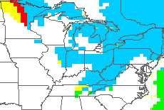
Temps today drop from the 40s in the morning into the 30s this afternoon. Morning rain showers will give way to a few snow flurries or a light snow shower later in the afternoon. A few flakes may hold tough into Wednesday on a strong northwesterly wind flow…
 Highs will range from the upper 20s to low 30s.
Temps rebound again on Thursday as we await the arrival of another cold front. This one just grazes the region with the possibility of some flurries or a light snow shower in the morning…
 Much milder air then pushes in for the weekend as our winds become southwesterly. Many areas should top out in the 50s with mainly dry weather.
A rainy system zips in here by Monday, and that starts a very active week of weather. It all starts with a big storm system that could bring thunder and high winds our way…
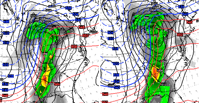
That storm will also be the key that helps start prolonged pattern of very wintry weather for February.
The Super Computer composite analogs as we enter February bring up some interesting matches. The winter of 1977/78 is legendary and was a late starter. Late that winter occupies 3 of the top 5 spots on the latest analog list…
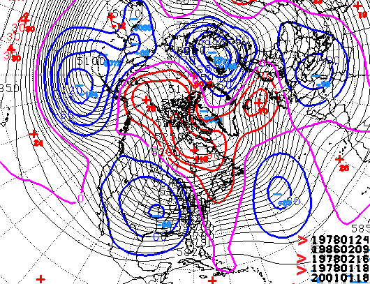
That doesn’t mean this will follow the same path, but it’s an attention getter to see the same year showing up that strongly.
Right on cue, the models show a deep trough building in the Aleutian Islands with a big ridge up the west coast. The end result is a deepening trough in the eastern part of the country…
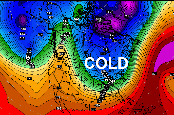
Check out the progression of the temperature anomalies in Celsius…
February 4th
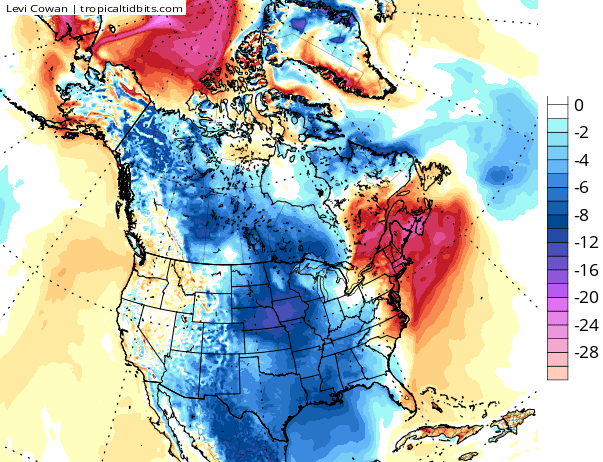
February 6th

February 9th

The pattern taking shape into February is one that can lead to additional extreme winter weather for much of the country. What form that takes remains to be seen, but the setup for another wild ride is there.
I will have updates later today. I leave you with your tracking toys…

Enjoy the day and take care.

I remember the 1977/78 Winter very well. I was only 7 but I remember the snow being up to my waist several different times that season. 77 was also the year of the biggest flood I have ever saw on the Tug River.
I believe that was the winter the Ohio River froze. I was working in Ashland at the time and several of us walked on the river.
I’m ready for spring now. That February 9th illustration is hogwash I tell you, pure hogwash. Have a great day everybody.
I wanna copy and paste this comment for further reference.. Lol
Ahhh … any time the winter of ’77-’78 is mentioned, Rodger grins! What a great time to be a kid with a snow every week and cold enough to keep it around for days and days. Snow forts, igloos, making our sloped concreted driveway into an icy wonderland, his dad’s ’69 Ranchero pulling him and his brother down the road on sleds. Thanks for the morning smile, Mr Bailey. Rodger in Dodger!
About 4:50 this morning a gust of wind hit my house at West Irvine that rattled all the windows and the house popped and creaked. No doubt that was the front moving in, but I don’t hear and feel winds like that very often and hope that I don’t very often!
I live in Keavy which is in southern Laurel County and I herd the wind also. It came for a little bit and was gone in no time. It was very strong.
Ain’t no way…or at least that’s what I’m telling myself! Last night all my snow (or most of it) melted here in CKY. I think the pattern will trend warmer with just a handful of flurry/ankle duster type snow “events”. While this last snow storm was a good one, I’m ready for spring! Thank you mr. Bailey for your always detailed forecasts, I’m just hoping you are wrong! 🙂
Let’s ride the winter train until mid-February and move on to warmer temps. I always look forward to the 2nd half of February because you start getting some days that hit 50s for highs.
Amen to that. Bring on the warmth!! I’m ready for spring.
Just say No to ice.
guess we should have taken the over on temps this week
The late 70’s winters was humdinger that i won’t forget. Like Rodger the Dodger said we had snow on ground from Jan tell March temps never got over freezing mark tell spring.
Looking forward to the warm stretch this weekend!
78-79…..epic winter, but I believe it all started the week after New Years and lasted through mid February. We Went back to school for a week and BAM!! We were out for what seemed a full month. Sledding hill at George Rogers Clark park in Louisville was a solid sheet of ice. Had to use the rail of your sleigh to pick your way back to the top. Sledding for days. I believe the river froze that year as well. Would love to see that again.
Yeah I remember missing about the entire month of February of school that year
I remember too being out of school for almost an entire month and then had to go on Saturdays to make up some of the time.
i might get some hate for this but I’m ready for thunderstorms and warm weather. I would rather see this than snow any day. I cant wait to see how the weather plays out Monday when the thunder comes in.
Haven’t had many severe storms, or thunderstorms for that matter, over the past two springs. The winters of late have been stealing there thunder….LOL. Looks as though it may happen again this year. Feb. is the month a few Mets have been talking up as the worst of winter.
I like warm weather as well, already seen more snow than I care to (even if I like seeing how the dynamics of snowstorms play out).
That said, NWS Paducah and other NWS offices have already lined up a few spotter c-l-a-s-s-e-s:
http://www.weather.gov/pah/spottertraining
NWS Wilmington OH
http://www.weather.gov/iln/spottertrainingschedule
Why doesn’t any ever mention the winter of 1976/1977? I was a SR in high school. We went one day, then the snow and cold hit and we were out the entire month of January, minus one day. Last snow was my kind, if there is such a thing: Here Friday, gone Tuesday. So do I go buy a snow blower?
January 1977 was when it snowed in Miami FL of all places…. 😉 .
I am not ready for winter to be over …….After next month, we will be in March (Chris Bailey’s Least Favorite Weather Month) – WHY? I dunno, but that’s what he said last year.