Good Wednesday, everyone. A normal late January chill is in the air for a few more days before things warm up for the weekend. The warm air isn’t going to hang out long as a strong storm system looks to bring drastic changes back in here early next week. That storm is likely the key to unlock another very cold setup.
Highs today will be in the 30s with mostly cloudy skies and some stray snow flurries. Winds will pick up on Thursday as another fast moving front drops in here by Friday morning. That should have some snow showers and flurries with it across central and eastern Kentucky…
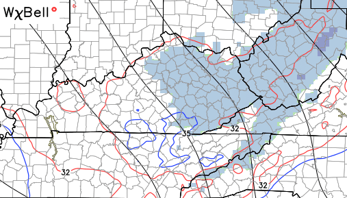
A sugar coating of snow is possible as this system moves through. Temps for Friday will be back in the 30s for highs.
Much milder air then moves in over the weekend with temps hitting the 50s to near 60 for some. Some changes are already showing up in the models for Monday. The GFS drives a cold front through here and knocks temps back into the 40s…
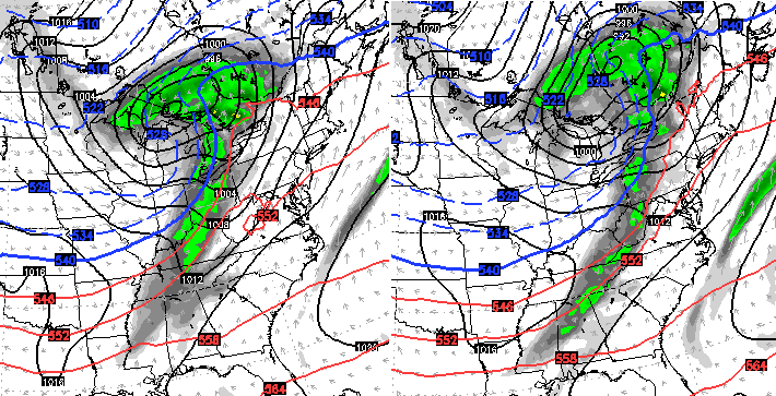
That may be a little too aggressive with how far south all that gets. Regardless, the next storm system looks massive coming our of the plains and working into the Great Lakes. This will cause temps to spike and has the look of a decent thunderstorm maker around here by Tuesday. Here’s the GFS…

Check out the cold coming in behind that system…

The European Model is very similar, but has more of a severe weather look…

No matter the setup, our overall weather pattern continues to go toward the extremes. We might as well get another severe weather maker before Old Man Winter crashes back in with some more wicked stuff for February.
I will have updates later today. Make it a good one and take care.

Can’t wait to hear about more snow chances!
Looks like I might miss my bold prediction of severe weather in January by one day.
Thelma Lou says that’s two days 🙂
Looking back to 77/78 there was a bit of a warm up with Thunderstorms before winter really got cranking. Happened in 76/77 as well. Looks like good analogs for this season as well. Winter is going to return with all its might through Feb and possibly March.
Thanks Chris for update. We are still snow covered here in Clay county. My road needs the temperatures this weekend for it even to melt. Looks like it will have a fresh coating by Friday morning. Good snow now to build a snowman, it packed good last night. Kids made one. Look forward to later updates.
Still have several inches on the ground in Laurel County. Our slushy snow covered roads are now rock solid ice for a couple of days. Love the snow, but look forward to a warm day soon.
Mr Bailey sees more possibilities for thumping snows in Feb! Rodger can read between the lines 🙂 Rodger in Dodger
Say it ain’t so. I’m still siding with the warmer temps and hoping last week was our only “thumpings”! I think the pattern will trend warmer, maybe an ankle biter or two, a thunderstorm, and lots of COLD RAIN.