Good afternoon, gang. It’s a cloudy and cold day for many of us across Kentucky, but a short mild-up is on the way for the coming weekend. As I’ve mentioned many times, it’s not going to last very long and the recent model runs are going nuts with the cold that follows.
Before I get into that, let me say a big thank you for everything you did with our recent wind driven winter storm. You made last week the busiest week in the history of this site with nearly 1.5 million visits. I really need to sell local ads on this thing and retire. 🙂
One snow shower maker moves in Thursday night and Friday morning. After that, it’s game on for the big weekend warm up. This leads us into a potent storm system moving our way late Monday and Tuesday. This could be a big thunderstorm and wind maker for our region…

The air coming in behind that is MUCH colder…

Wraparound snows will be possible as that northwesterly flow kicks in for the second half of the week.
The models are all going gangbuster with the cold shots that follow that up. The GFS even brings the PV into the United States…
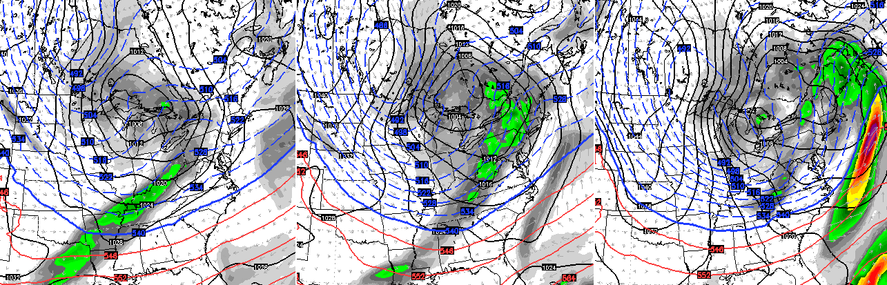
Brutal cold…

The Canadian Ensembles are similar…

The European Ensembles 5 day average temp anomalies at 850mb have a similar look…

Buckle up for a wild winter ride as we get into February. It has that extreme look to it… Again.
Enjoy the afternoon and take care.

Chris, do you think all that cold will have much snow with or not?
Nope lol Hate cold with NO snow… There is a southern system showing up around the 11th but thats way off. the track looks good for a good snow around louisville north but that will trend NW as always…
Can’t wait!!!!! Thanks for all you do!
Oh no, not that” P.V.” Word….I love the snow but not the PV
what does P V mean?
now I know what it is.
Thinking no more snow for us, at least not like the big one we just had. Maybe 1-3 inch accumulations. I get the feeling Chris means extreme weather in the sense of cold temperatures.
Booo cold weather. Bring on spring!
Well a big winter cold snap was bound to happen, cant believe the polar vortex is a possibility
Air that cold wont have snow with it. The dew points will be too low, probably around zero. We`ll need for a warm up after this cold snap to get snow, just not too warm, around 28 would be awesome.
Tim i’ve seen it snow with heavy flakes while its 15 degree here in ky. It was one of worst storms that has hit here. So it can happen.
Seems everyone is on board today! No more snow! Both in not wanting it and thinking it’s not gonna happen. I agree. Bitter cold for the “extreme”, no significant snow. It’s going to be a long boring couple of months or more. Hope no one invested in new snow gear or sleds!
I’m not on board with that at all.
Haha! Everyone but the boss man himself I should have said!
Even though I’m not a fan of more snow I trust your forecast Mr. Bailey. I’m simply trying to use reverse psychology on the weather!
Thank you!!
Frankfort area was on the low end of this past winter storm, one more big one and
bring on an early spring?
My skin and heating bill would love that! 😉
☹️ I was hoping we wouldn’t see any more brutal cold. Oh well..
Uh oh he said p.v. polar vortex ,southern jet,se tn…= southern snowstorm… 🙂
Ready for more cold and snow. Big time severe possible next week. Wouldn’t mind seeing some short shorts before the pv returns
I say sell the ads, but just don’t retire!
With all the extra you do on the side to keep us informed you deserve to make a little from it. Just no pop up ads! 😉
Thank you for all of your hard work and for being so open to share with us! You’ve got an awesome personality and we appreciate it!
Here’s my shopping list…
1. A week of very cold – I mean sub zero lows and teens for highs – cold enough, long enough to kill lots of the little insect and squirmy eggs and larva or whatever that is underground waiting to hatch an wreak havoc come spring and summer.
2. One more snowfall for my part of Richmond of at least a foot.
3. A couple of snowfalls of between 4 and 8 inches.
4. Snow hanging around (not all melting – not much left in Richmond) for at least two weeks.
After that, I will be ready for spring. So, there you have it. NOw it is Chris’ hands to make it happen.
I come to your site over all the weather sites available. You are the most accurate and should be part of the weather channel team. I hope your station appreciates you! You are too good for Lexington! Blessings and keep doing what you do best!
Too cold to snow? I think the out of the two blockbuster storms we had in Lexington, the first one the temp was 12 degrees during MOST of the snow storm event…I don’t think the March storm was quite as cold. That was the coldest big snow I’ve ever lived through…..Most of the big snows were in the 20s
Going to get wild over the next two months after this slight warm up. Winter has just begun. Think Snow…
Chris, we really all love you and your blog.PLEASE DON’T RETIRE!!!!!