Good evening, gang. The weather continues to look like it really wants to take a big walk on the wild side as we roll into February. There are several extreme options on the table with the setup I’m looking at trying to develop.
After tonight’s snow shower maker, we focus on warmer air for the weekend. That warmer air will boost temps into the 50s to near 60, but also may throw some showers our way Sunday night and Monday…

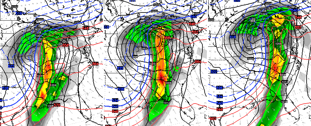
You can already see a much bigger storm developing across the southwest. That storm is going to absolutely crank into a monster in the plains states by Monday and Tuesday. It will likely have a blizzard on the cold side and a severe weather outbreak on the warm side…
For us, that could mean record highs on Groundhog Day Tuesday as winds crank to 40mph or higher. Strong to severe thunderstorms would then roll eastward that afternoon and evening.
Temps crash behind that and could be 40 degrees colder by late Wednesday as some wraparound snow showers fly.
This leads us back into a winter pattern that has harsh written all over it for much of the country. Look at the temperature 850mb departures behind that front on the GFS Ensembles from WeatherBell..

Let’s look a little farther down the road. The AVERAGE from the European Ensembles for a 5 day span in Celsius…

To see those kinds of numbers from an Ensembles run for a 5 day period is astounding. Now look at the extreme look at 500mb…

Yowza!
I leave you with your snow shower trackers…

Have a terrific evening and take care.

This is going to be an interesting Groundhog Day, especially for the Western third of the state. I know the SPC mentioned all modes of Severe WX, but does anything stand out to you as showing tornado potential?
I find it fascinating that The Weather Channel will not quit showing much warmer than average temps across the Eastern U.S. because of the current strong El Nino in place Now the main stream weather provider is displaying forecasted temps over Feb through April resulting in much above average temps for our neck of the woods. It is like most meteorologists cannot let the warm/dry El Nino weather for most of the Ohio Valley and East go (lol)! If February pans out as the models are now starting to show, we will have to receive a very warm March and April to achieve the much above normal temps predicted over the next three months. Let’s not forget everyone screaming about dry weather for the fall and winter over our region.
Precip totals at my house near Harlan KY since late Fall:
November-5.05 inches
December-8.32 inches
January (through today)-4.97 inches
It really has been dry, hasn’t it–;)
Thanks Chris.. Looks like an interesting week ahead…glad we have the best meteorologist in these parts to guide us through and keep us updated. Happy Friday Eve all.