Good Saturday, everyone. January is ending on a rather quiet note and I suggest you get outside and take advantage of it. February is ready to sweep in on a super active note and the pattern appears to be skewed toward the extreme for the month as a whole. There is some “wow” in this setup.
Today is a different kind of wow as temps make a run toward 60 under mostly sunny skies. Winds will be very gusty from the southwest and that carries us into Sunday. Clouds increase then as a cold front moves our way. A band of showers will move through from late Sunday into early Monday.
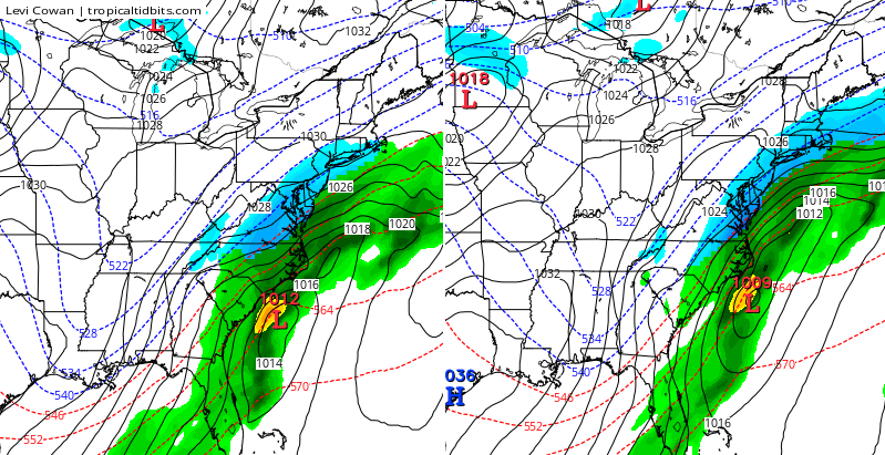
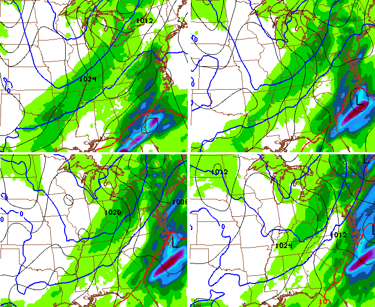
Temps by Monday drop several degrees, but get set to bounce back up into Groundhog Day. This is ahead of a monster storm crossing the plains and heading toward the Great Lakes. We’re on the warm side of this and will have to be on guard for strong and severe thunderstorms. Watch as this line develops on the GFS…

The severe weather threat continues to be there with damaging winds taking on a staring role. A conditional tornado threat is also present from our region and points south.
The front appears to be slowing down a bit as it moves through here and that could allow for another wave of low pressure to develop just to our east by late Wednesday and Thursday. The Canadian has that possibility…
Much colder air continues to push in here for the second half of next week. This leads us into a pattern ripe for extreme winter weather events across the country. I’m looking at the February 7-11 timeframe for something to try to develop. The signals are there on most of the models. The GFS during that time…
The European Model at 500mb is textbook for something big happening…
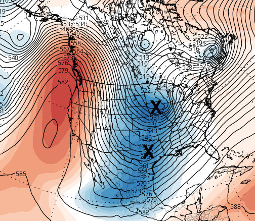
A MONSTER ridge up the west coast with a system from the northern branch diving into a system coming out of the southern branch of the jet stream.
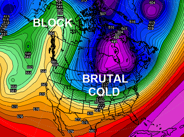
Wanna see more extreme? This 500mb setup puts the entire country in the deep freeze during the second week of the month…
I will have updates later today. Make it a good one and take care.

Sure do like the 06z run of the GFS…showing alot of snowstorm love !!
My wife loved the last snow (about eight inches at our place) although I’m ready for spring 😉 . But I’m realistic that we have a lot of winter left. Besides, I still enjoy tracking snowstorms, even if Caribbean weather may be on my mind!
I was wondering how much you guys got at your house..just wasn’t favorable for my area I did squeeze out a couple inches ..hopefully I’ll be able to get in on the next one..
A big drop off from north to south a week ago. Northern parts of Davidson County had 10 inches or more, far southern areas of the county as little as four.
The big January 2011 snow was the opposite; the Tenn-Alabama line had up to 16 inches, Nashville maybe 4. I was in Bowling Green KY then; didn’t get a single flake!
Thanks, CB!
As Chris alluded to, a few tornadoes can’t be ruled out for Tuesday of next week. But compared to earlier outlooks, the SPC currently feels that instability and shear (two of many ingredients that help tornado genesis) may be somewhat less than expected on Tuesday. Thus at this time, a storm this Tuesday like the scope of the “Super Tuesday” tornado outbreak of February 5, 2008 appears to be fairly low, thankfully. http://en.wikipedia.org/wiki/2008_Super_Tuesday_tornado_outbreak
Still something to keep a watch over, as it only take one strong tornado. Also, damaging straight-line winds are nothing to sneeze at.
In the meantime, everybody enjoy today’s nice weather! 🙂
Great update, Chris. I sure do hope we get the southern stream working into that big time cold.
Thanks to TennMark for the tornado expertise. Crazy weather.
Go Big Blue!
Thanks, retro fetch. Largely good training from storm spotter c-l-a-s-s-e-s. But also motivation gained from scary near misses.
When I was a teenager, a twister hit just a few miles away with one fatality (April 16 1998, same day as Nashville’s downtown tornado and Bowling Green’s big hail storm). After the April 27 2011 outbreak, a nerve wracking eternity seemed to p-a-s-s before I finally learned my parents were fine; a high-end EF4 had missed my folks by about eight miles. I later viewed the unbelievable devastation, something I will remember the rest of my life.
When he says extreme is he talking snow or just cold.
This is definitely going to be an crazy wild setup to watch! Thanks CB for always keeping us updated on the latest trends. We appreciate it more than you know!
Chris do you foresee another big snow storm for ky in feb. What’s your thoughts?
Thanks Chris. Been out enjoying today’s beautiful weather and keeping one eye on your blog. I have been here since you started this ting, and I know when you keep pounding on an upcoming event possibility, it’s one we need to pay attention to. So I am wary about Tuesday’s weather set up. Thanks in advance for keeping us updated and safe, as I know you will! Have a great Saturday everyone. Enjoy!