Good Sunday, everybody. January is wrapping up on a rather opposite note compared to how we spent much of the month. Mild temps today will carry over into the first few days of February, before much colder changes thunder into the bluegrass state. That thunder threat could even lead to some severe weather.
Let’s start with today and roll forward.
Highs will be back in the 60s for many as clouds increase. Those clouds will eventually produce some showers later today as a cold front works in. The simulated radar from the Hi-Res NAM shows the action tonight and then moving away by Monday afternoon…

Temps on Monday will be much cooler than this weekend, but will still be above normal.
Much milder air surges back in for Tuesday as a huge storm develops across the plains states. That works into the Great Lakes by Tuesday night and drags a cold front into our region. A line of thunderstorms develops along this front and some could be severe…

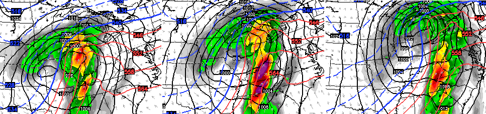
This setup, while still threatening, isn’t as potent as what the GFS was suggesting a few days ago. The Canadian Model still has the potent look…
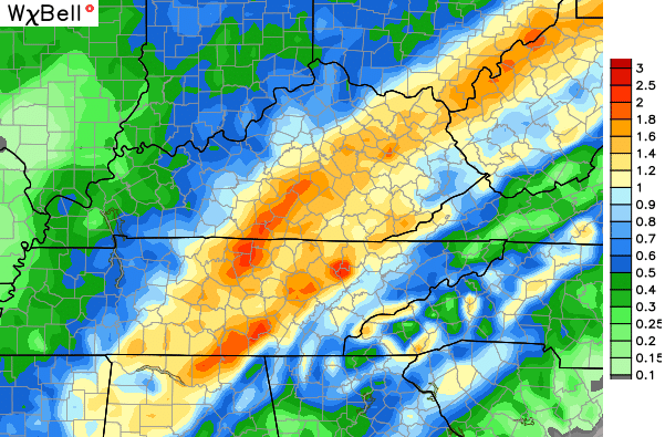
Where this line of storms develops, heavy rainfall is a good bet. Here’s the GFS rain forecast…
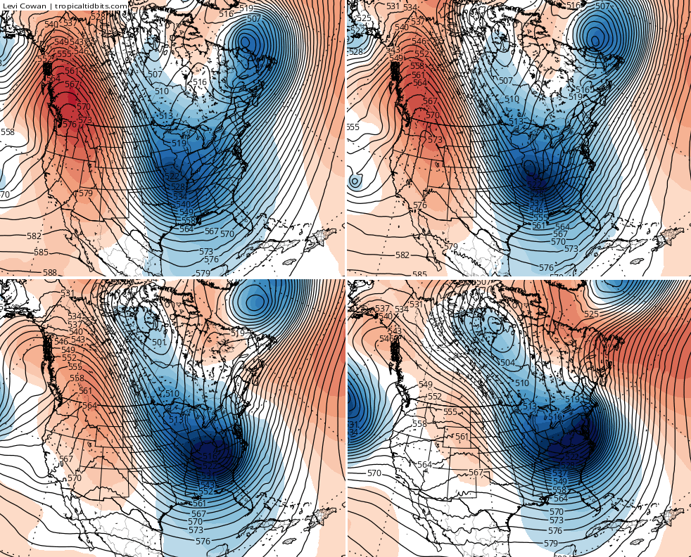
Much colder air comes in behind this system for Wednesday and the air grows gradually colder through the end of the week. Many of the models are now showing a clipper type system diving in here with true arctic air to start next weekend…
That could be a snow maker with gusty winds and bitterly cold temps blowing in.
The system behind that continues to be the one that stands out. This is a threatening look from the GFS at 500mb…
I will have additional updates later today. Your radars will help you track the late day showers into the region…

Enjoy your Sunday and take care.

First! So now the Euro and the GFS have the a big storm next week. I like that. Hope we get a few more nice snows before the end of March arrives.
Wonder if the second half of February and first half of March will be a repeat of last year? Things that make you go hmmm….
Good news next week does not appear to be as serious.
My weather channel app certainly isn’t as great as predicting the weather as Mr Bailey but looking ahead it’s got something around the 10th or so. Lots of mentions of 1-3 inch snows. If I recall before the last storm it started doing that too. Fingers crossed all those sleds and snow boots we got after the storm get put to good use! I was hesitant to buy anything because sure as I do we won’t have another flake! But I’m coming back round to the ol snow bandwagon. This is a nice little warm up. If we can continue to have these between the snowstorms it makes it a little more bearable. Hope Tuesday is not too bad. I read somewhere else the CAPE seems to be disappearing. I didn’t know what superman had to do with any of it, then I realized it’s what makes the severe be more severe. Ha! Who says an old dog can’t learn new tricks! Thanks Mr Bailey.
Not a big fan of the weather channel app or their site either. They are wrong too often from as little as a day out.
Also, people use their site. And they will have an extended outlook of 50’s-60’s for the 10 days. In a few days those temps. are back down to the 40’s or even 30’s. With this last one it would not be so bad. But I saw an article on there about the February-April time period. They listed all of Kentucky as above normal or well above normal for temps. Had an ECMWF model the would contradict what Bailey has shown for that period. Now, they have another extended outlook. Shows Kentucky and the eastern part of the U.S. as below average for February. Just days apart.
Hoping one of these systems put down some snow for SW Ohio. So far, in Hamilton (north of Cincy), we have had just under 2″ for the season. You all had that major storm a few days back and now this major storm to my north. Talk about a doughnut hole. You are theman CB. When I lived in Keavy, I depended on you for accuracy and you never failed me. I am still depending on you from the Cincy area. Talk more aboutN. Ky so I can be ready. LOL
Thanks Chris. Happy to hear Tuesday may not be quite as severe as we thought. I understand that Is NOT saying we won’t have severe weather, but glad at least some of the models are not as potent as we first thought! I’ll take it. Have a great afternoon everyone , and thanks again Chris.
Hi Coffeelady. Thanks CB!
Forecast Discussions from NWS offices in Paducah and Nashville have indicated that if there will be a higher tornadic threat on Tuesday, the western parts of Kentucky and Tennessee (also into the Deep South) would be in the crosshairs.
But as the storms move east, it’s felt that shear will weaken somewhat thus less of a tornado threat. Eastern parts of KY and TN will still face damaging winds and more isolated twister chances.
We are two days out, so plenty of time to see how the models better zero in on any severe wx.
Look forward the blog get ramp back up as the cold air returns and possibility snow on super bowl weekend or after.
Such a nice day. But the snow is trying so hard to hang on. Most is gone and I am sure the rest will be gone by tomorrow morning or so. But the ground is a soggy mess with water standing here. Rain is definitely not wanted yet.