Good afternoon, everyone. Phase two of our winter storm is about to get underway with heavy rain and a band of heavy snow. The heavy rain part of the storm may cause high water issues across the south and east. The heavy snow band remains a little more of a mystery, but it’s starting to show itself.
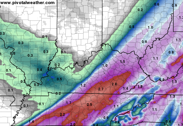
Heavy rain overspreads central and eastern Kentucky from the southwest this afternoon. As our storm system strengthens, cold air is wrapped into the backside of it, allowing for a band of heavy snow to form. The short range model known as the RAP is strongly supporting recent runs of the European and NAM. Here’s the RAP tonight…

You can clearly see how the snow wraps up on the backside of the storm.
Here’s where the latest run of the NAM has the heavy snow band…
 That’s a smackdown for much of central and eastern Kentucky. The Hi Res NAM is a little farther west…

That the placement on that actually matches up well with the short range models coming in. Trying to pinpoint where this band sets up is tough, but here’s my first shot at it…

I will have a true first call on this coming up today at 4pm on WKYT-TV. I will also be showing you the fresh short range models. Those update every hour, so we will check them out together.
Even though you’re more interested in the snow potential, don’t sleep on the possibility of flooding. Look at some of the precipitation totals over the next 24 hours…
Watch the creeks and streams very closely.
I will have additional updates as needed. Your current trackers will keep you company…


Enjoy the afternoon and take care.

Wsaz calling for rain and giving no snow for Huntington area tonight. They dropped the ball on the storm last night. Could they be right today?
They tend to drop the ball a lot so I never watch them anymore.
Sorry, Chris but I hope the snow does not materialize as much.
Preach it, brother man.
100% This and think CB would 100% agree.
Driving back down to Crab Orchard for work tomorrow, so I don’t want to see too much snow. 😉
Supposed to be leaving tomorrow morning for DC, so I’m in total agreement!
Pikeville received about 5-6 inches of snow and northeast Pikeville in the Belfry area received about 7-8 inches of snow. Just a few degrees cooler and we could have had a huge snowstorm here in far East Kentucky. It’s currently 34 degrees in Belfry with a steady rain/mix. Hopefully Pike County gets in on the heavy snow band tonight but I’m afraid we are too far east. Even though I live in Kentucky all of my local news channels are based out of Huntington and Charleston and as usual Chris was on top of things well before my neighbors to the east. Thanks Chris you are the best!
Where at in Pileville? 3 inches is all Coal Run got.
Bob Amos Park…granted it’s higher elevation but early this morning I measured between 5 and 6 inches at a few different spots.
Thanks Chris. OI don’t know where the snow will set up, but I do know that the cold rain is making the slushy streets (side roads) a very slick mess! Just enough to make it that way, the heavy stuff has not shown itself yet. It is raining but we are also right at 32 degrees right now. Guess we will wait and see.
Have a good afternoon all, and stay warm and safe.
Looks like someone will hit a brief snow lotto tonight before it warms up this weekend. My gut tells me it will be slightly to the east of CKY but I’m hoping my gut is wrong. The kids and I would like to turn the 3-day weekend into a 4 day weekend. We were bummed this snow hit on holiday and not a school day! Thankfully the roads are clear though and we can still get out and enjoy the day. Thanks Mr Bailey for keeping us informed. It’s been a fun few weeks of tracking. We are looking to track a few more before Spring moves in!
The more days your kids are out for snow, the longer the school year lasts.
Actually some schools have snow days built in. I know my kids can miss 6-8 days before it affects the last day.
Enough
No one around here is giving much, if any snow for tonight or tomorrow. From what Chris says I bet we will. Right now it is 37 and raining.
Latest HRRR is bringing it more west!!!
Josh how far West?
Getting real close to Louisville
It is only about 1-2 counties away from Warren.
Thank you 🙂
Oh please, please!!! I had so much fun building a snowman with my daughter today. That snow rolled up like a rug! Don’t get me wrong, I’m a teacher in JCPS and do not want to be in school until the end of June. However, I do love the snow!
Oh please, please!!! I had so much fun building a snowman with my daughter today. That snow rolled up like a rug!
Do you have a link? I would like to see this. Thanks.
I’m am “willing” it to the far west to keep me from losing power and or shoveling heavy snow 🙂 That or far east. Either will do 🙂
I guess wherever the band of snow develops would then move east ….unless it just disappears (:
Looks like BG is going to get shafted barely by tonights heavy snow; however, I am okay with that since we have already received 23.7″ this season so far.
One person’s shaft is another’s gift 😉 Heavy wet snow over five inches can be as bad as ice and in some cases worse if more snow. One of the few times I hope the snow models are aggressive with their cold factor.
And wrong.
NWS Jackson mentioning the changeover to snow with rates of 1-2 inches per hour with it moving pretty fast. My question is what time will this change over occur?
Just saw your tweetMr Bailey. I hope people respect this is a tough call and sounds like a narrow band of snow. I wouldn’t want to trade places with you. Thanks for trying your best in determining where this band will set up. Good luck with the snow lotto tonight folks!
You accurately predicted this winter’s weather. Are you omniscient enough to predict this summer’s weather or even next winter’s possibilities given the accuracy of this winter. Thanks for the head’s up on this winter. I definitely was prepared for it.
Chris mentioned a band of snow for Tuesday in one of the post yesterday. Is that still a possibility?
We might get in on that snow tonight in Rockcastle
What is the timing of this changing over to snow. Will it be during the night before school busses start running?
He said in his last tweet that models are showing it little more east then the midday update
All I know is that Harlan has only reached 37 degrees at 4:25 PM with a forecasted high in the mid to upper 40s, so I am concerned that we might get smacked tonight unless the precip moves out of the area to fast! As of now, all we need is the upper level dynamic cooling to reach this area. In reality, it is already cold enough for wet snow.
No offense CB, but this is one time I’m hoping BM finally gets a forecast right. C’mon he deserves at least one. Thanks for all you do even if it’s not what I wanna see!
He has to get one right. Seems charitable.
Hmmm… NWS LOU just issued a WWA for Simpsonville in effect from 10pm tonight to 7am Tuesday; accumulating snow expected late this evening into overnight hours. Simpsonville is just down Shelbyville Road from our neighborhood.
No tweets by CB for two hours. Maybe warm air wins….
Not according to his newscast
Chris said on the news that a lot of areas would see 12 inches shy of a foot of snow
12 inches shy of a foot is zero 🙂
😉
Glendale…just rain right now. Hope that’s all it is, but so is the weather in Kentucky.
Will this affect Huntington Wayne areas?? Our mets missed the storm last night and my grandson got caught it because we had no idea it was going to snow so much.
I think our mets have missed ever since CB left us! I always follow CB and heck with the local mets
Completely agree. I do not even bother with Tri State meteorologist, I always listen to Chris. He knows his stuff and is willing to put it out there. He does not wait until there is three inches on the ground, and then give a three inch prediction. Keep up the great work Chris, we appreciate you!
Would also like to know what will happen in Charleston tonight,,they are saying maybe 2 inches starting at 4:00 a.m.
As usual, the other guy has half the total and further East.
Who is the other guy?
BM. I have yet to see similar snow casts. Seems to always understate.
Radar taking on an interesting look, the heavy narrow band developing between Lexington and Louisville might be where the change over begins. Just my non educated guess.
A few snow flakes falling in frankfort. no rain yet, temp down to 34 ??
Will probably be on the western edge of the good snow, east of frankfort lookout!
I figured he would have had a evening update by now just looked at the radar seeing nothing but green at the moment
I’m feeling les and less confident. Like freshman year when I asked Mary Jo Hopkins to the winter ball dance. Hope this snow turns out better than that did.