Good Wednesday everyone. The number of tornadoes that touched down across Kentucky on Tuesday continues to grow. We are now up to 4 confirmed touch downs and the NWS is still surveying damage across the region.
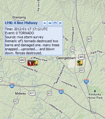
An EF-1 Tornado packing 90mph winds touched down in southern Scott County.
An EF-2 twister moved across Allen and Simpson Counties.
Two other tornadoes touched down in Jefferson County. They were both rated as EF-1 storms with one touching down in northeastern Jefferson Co. with the other across the southeastern part of the county.
This makes an amazing 7 tornadoes that have touched down in Jefferson County in the past year. That’s right… 7 tornadoes have hit the Louisville area since the end of last February. WOW!
I will have another update on the weather ahead coming up this evening. Take care.

Oh my!! This is bizarre Janurary weather even for Kentucky!!!
Very concerned about the lack of a tornado warning for Scott County yesterday. If you draw a line between the damage reports, there are 4-6 schools in that path and they did not take cover since there was no tornado warning. This comes 6 months after heavy damage in my subdivision, over $100,000 on my small street alone, from an unwarned storm last August. Why isn’t Scott County getting the warnings as needed?
Ask the spc\nws only there will you get your answers
This particular twister was an EF1 with a path length of less than half a mile.
http://www.crh.noaa.gov/lmk/?n=jan17_2012#scott_ky_tor
Total guess (anyone feel free to correct, including Chris Bailey and other pros), but perhaps this twister was too weak and short-lived to give much warning, especially if it was a squall line twister.
http://www.crh.noaa.gov/lmk/soo/docu/bowecho.php
Interesting if dual polarization radar would have improved things in this case. Louisville and Jackson KY will get their dual pol upgrades this fall (Paducah, Ft Campbell and Evansville in early 2013). Nashville is getting their upgrade now. Memphis, Huntsville (Hytop AL) and Peachtree City/Atlanta are now dual pol radars.
As of Wed late evening, nine tornadoes have been recorded in Louisville NWS coverage area, including one EF2.
Chris, we were really lucky here in Somerset yesterday. We did get wind, and very heavy rain. But we did not get any severe stuff. We DID, however, get some very light spitting snow flurries here this morning. Finally saw the sun trying to peek through just before 5 this afternoon. And I agree…very strange weather, even for Ky. Guess the old adage is true…if you don’t like the weather in KY, stick around; it will change. 😉 Have a good evening, all. Looking forward to the next update, Chris.
Well, I guess fans of snow in Seattle are disappointed since they got majorly downgraded. Just two days ago it was up to 16 inches of snow, and now, it’s a winter weather advisory with light accumulations. To read the wording in their forecast discussion I saw nothing to indicate that they weren’t CERTAIN this storm would happen for them. Usually in our forecast discussions when possible winter weather is expected you see wording like, “depending on the track, WAA could possibly limit accumulations, etc.
I’ll bet alot of snow lovers in Seattle are saying what happen, yesterday most big weather outlets were saying mega storm 12to18in record snows in that area. See folks the models & mets can miss big time!
yeah they had 5″ earlier, and now I think it might even be raining there…
LOL…just got a tweet (JimCantore): official snow total for seattle (sea-tac) came in at 6.8″ for the day. average annual snowfall is 5.9″ alot of the higher elevations right outside of town had double that..
I know! I mean the forecast changed that drastically in just two days.
Today is Wednesday. And what we see happening for friday/sat (now) could completely change by then.
we better cross our fingers!
00z nam hates Kentucky with tomorrow’s clipper.
weekend does not look at all promising either:(