6pm Update
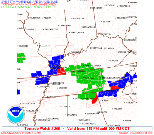
A TORNADO WATCH is now out for far western Kentucky until midnight. This is PDS Watch… Particularly Dangerous Situation.
Here is the watch outline and the latest warnings…
Take care.
Previous Update
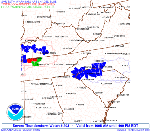
Good afternoon everyone. A SEVERE THUNDERSTORM WATCH is now out for parts of south central Kentucky until 8pm CDT. Damaging winds and large hail are the main factors… but an isolated tornado can’t be ruled out.
Here is the watch outline and current warnings…
Other storms will fire up outside the watch box and these can go severe as well. The next few days will likely see a MAJOR OUTBREAK OF SEVERE WEATHER across our entire region! In addition to the severe weather… MAJOR FLOODING will be likely for many areas. This next go around of flooding will likely include parts of central and eastern Ky in addition to the areas already getting hammered.
Track the storms here….
I will have updates as needed and will send out quick thoughts and warnings through twitter. Follow me at Kentuckyweather or follow along in the twitter feed on the right side of the blog.
Take care.
Select Page
Chris Thank You so much for Keeping us all up to date and preparing us for this upcoming week. It seems it might be a rough week especially witht he flooding across the entire state. Thank you again for monitoring and keeping us up to date on the latest weather conditions. You are by FAR the best in Kentucky!
I noticed that tornado watch is a PDS, any chance that central ky be in on PDS later tonight or tomorrow?
Running live blog for those interested….
I really appreciate the time you take to share weather info with all of us 🙂
Thank you very much 🙂
Little Rock has apparently gotten the Raleigh/St. Louis treatment. Weird how these tornadoes seem to keep affecting metro areas.
LIVE streaming video Little Rock AR
http://www.firedominator.com/index.php?pag=live&Stream_ID=626
Wow, that is ugly. Been to the Little Rock River Market. There’s a place there called “You Don’t Know Jack S***.” Owned by Sidney Moncreif. Great pizza.
Been watching LIVE video of rotating wall cloud in Little Rock
North of Little Rock in that other cell is where they are saying the large tornado is on the ground..
I’m certainly no weather expert, but this year is the first time ive ever heard the term “debri ball”.
Debris Ball=Bad News.
“this year is the first time ive ever hear the term ‘debri ball’.”
Same here. Not a Good Thing.
Is the severe weather going to moving into the south bluegrass region tonight? or is it expected to stay more to the west?
Is the large severe system expected to stay in the western part of the state or will it be moving into my area (Somerset) in the overnight? I <3 moderation! (ha!)
What is a debris ball?
Hearing some rumbles of thunder in Staffordsville in Johnson County….storms rolling NE as we speak 🙂
Chris What do you think is going to happen in cynthiana?
Actually its not just thunder….vivid lightening and dime size hail.
A debris ball is reflectivity from doppler radar of actual debris being picked up by a tornado that is on the ground and causing damage. The radar is sensitive enough to pick up the debris…
Somebody feel free to come along and try to explain that in a different/better way.
I have a snapshot of the radial velocity radar of the Vilonia, AR tornado. Debris cloud showing up on radar and reports of roads being pealed up. This bad boy was a monster of a tornado. What an active spring!!!!
So for those who watch The Weather Channel, Dr. Greg Forbes is giving eastern KY a 6 on his Torcon scale for Wednesday. This weather pattern has been absolutely unreal, and the radar signature off the Vilonia, AR tornado was the scariest thing I’ve ever seen in my professional career.
Shane do you have a screenshot or anything to the radar signature?
Will the line in far western ky hold together and affect south central ky? If so what time frame will this be moving thru?
http://okcstormwatcher.wordpress.com/2011/04/25/vilonia-arkansas-and-little-rock-air-force-base-raked-by-major-tornado/
here is the link i found that has a story and radar images of that tornado…Scary is the only thing I can say about it….The worst ive ever seen…
http://twitpic.com/4pk6ul
http://okcstormwatcher.files.wordpress.com/2011/04/4_25_11_ref-srv.png
should move through in a few hours, a new watch has been issued for our region.
that screams tornado lol.
Thank you Mitch, I hate this storms at night.
AP reporting 5 dead in Vilonia, Timmer says he expects NWS to rate it an EF-5. I’ve never seen gate to gate like that on a Radar ever!
http://okcstormwatcher.wordpress.com/2011/04/25/vilonia-arkansas-and-little-rock-air-force-base-raked-by-major-tornado/
here is the link i found that has a story and radar images of that tornado…Scary is the only thing I can say about it….The worst ive ever seen…
yha r wrywz
op cheap flights to new jersey
xb information about new jersey
love the site!
Hi, I agree with every statement that you have made in the post and I really appreciate your effort in gathering up the information. Thanks for it.