Good Thursday evening gang. The potential for significant rainfall continues to be a major concern as we head into the upcoming Easter Weekend. That is especially true across western and northern parts of the state where a Flash Flood Watch is now in effect.
Showers and thunderstorms will develop and move in very late tonight into early Friday as some warm air surges in from the southwest.
A cold front will then slowly settle southeastward toward the region into the weekend. This front will put the brakes on and should lead to repeat shower and thunderstorm action along and just ahead of the front. A general 1″-3″ of rain will fall across areas under the watch and some spots could pick up close to 4″.
Here is what the new NAM rainfall map shows…
That is through Easter Morning and shows close to 4″ of water falling across north central Kentucky. This would lead to flash flooding and likely some river flooding. The Ohio River is rising once again and Flood Warnings are out along the mighty river with expected crests likely not taking place into next week for many.
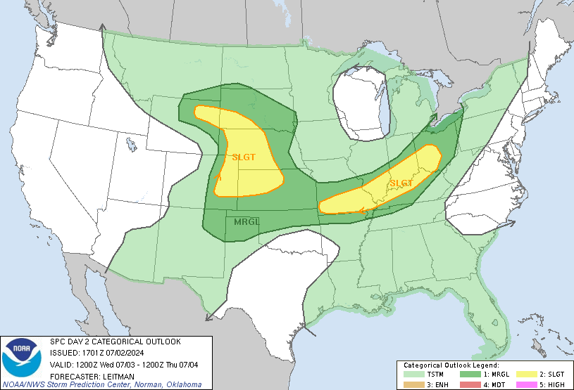
In addition to the high water threat… some thunderstorms may become strong or severe Friday into Friday evening. The Storm Prediction Center has much of the state in a risk for severe storms…
Busy times ahead and the blog will be there with updates as needed. Have a great Thursday evening and take care.
Select Page


Question for Lexingtonians. We have weather alert sirens in Lexington, and they are all located in parks. We have one right behind our house in Merrick Park. After the Masterson Station tornado in 2004, which occurred at night, Mayor Isaac was highly criticized for the fact the sirens did not go off that night. Her explanation was that the sirens were only to clear the parks, and thus did not need to be used at night. When Newberry took office, they started using the sirens at night. We have had two nocturnal events in the past two weeks, and the sirens have not gone off. Has Mayor Gray gone back to the Isaac policy? Anyone know anything?
Thanks Chris
Off topic help needed:
My driveway in my subdivision is just crumbling in the middle. I notice that a lot of the driveways in my subdivision that are LEVEL are having this same issue, but the driveways that are slanted are not. I supposed water/salt etc just sits there whereas it runs off the slanted driveways. At any rate, does anyone know the best place that can do driveway repair. It’s just an average driveway.
Thanks
http://www.wral.com/weather/story/9475479/
Don’t think I ever seen someone drive their family INTO a tornado when they see it coming.
Maybe this guy should buy T.I.V. to take his family on the next trip!
Crumbling how? Is it “eroding” away at the surface or does it look like the driveway is caving in? Do you know who build your home?
*built
It’s chipping really bad in the middle. Like when you sweep, small pieces of concrete come up and it has gotten progressively worse. It’s not really cracking or uneven or anything. I guess eroding would be the best word. The house was built in 2004 and yes I know who built it. It’s 6.5 years old.
absolument incroyable. l’air si délicieux i veux que ce soit! J’ai mis ton blog dans mes inspirations:) love it.
do you want to enhance your business? and looking for best website designing services at affordable cost? coolcreation.co.uk is only the single answer for your all queries. Now get all the services at reasonable price.