Good… what day is this? Oh… Good Wednesday to one and all. We are coming off another big severe weather event across the state and enjoying a nice break in the action. This break won’t last long as more storms and heavy rains move back in Thursday night and last on and off into early next week.
The storms last night packed a heck of a punch. The NWS folks are out surveying damage and did find an EF 0 tornado that touched down near Frankfort in Franklin County. The damage across northern Kentucky looks to be caused by straight line winds of up to an amazing 120mph! WOW!
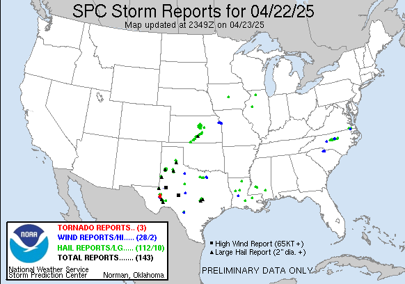
Here is a look at the updated reports map from this last event…
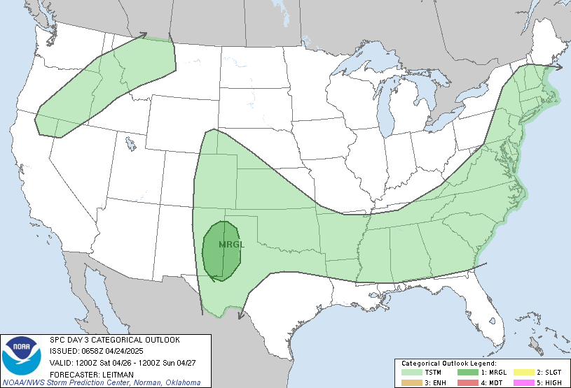
As mentioned… we catch a dry break through Thursday. A warm front surges northward Thursday night and early Friday with rounds of thunderstorms returning. Some of these may be strong or severe and the Storm Prediction Center has much of the region in a slight risk…
This setup will also bring more heavy rains that will likely cause more flooding problems. Here is what the NAM sees from Thursday night through Saturday…
The folks at the HPC are showing up 4 and 5 inch totals through the weekend…
Moral of the story… more severe weather and torrential rains will be likely late week into the coming Easter Weekend.
Have a great… ummmm…. let’s see… oh yeah… Wednesday and take care.
Select Page
It certainly was a scary night! I thank you Chris for all the tweets and updates on the blog. As for thursday into friday, please think of my in prayers as I traveling to Florida to participate in the spreading of my son’s Dad’s ashed into the ocean. I’m gonna need them all!!!
I can imagine that flooding will be a big problem this weekend.
Thank you Chris.. Your the best for your forcasts and dedication.
I love the new SPC set up for outlooks!
Did anyone notice the preliminary tornado reports? I did not see Clark county Indiana nor Franklin county Kentucky. Yet, they have had confirmed tornadoes from this past system.
In other words, MORE actual tornadoes than preliminary reports. Some complain about ‘inflating numbers’. Well, there’s another dent in that assertion!
Also, remember this. on my blog, I talked about tornadoes skipping. Tornadoes do not skip; therefore, anytime a vortex is not in contact with the ground, but then touches down again, technically, it’s a SEPARATE tornado. This is what I think happened in Clark county IN. Two actual tornadoes, although the same vortex caused the damage.
So, when you think about the tornado report side of things, I believe the actual tornado occurrences are grossly underreported. Again, no inflatable numbers there.
By the way, recently in another month, I believe it was February, 16 actual tornadoes vs 10 preliminary reports.
The NWS survey crews will be conducting additional analyses of storm-damaged areas.
Admittedly, some reports in MO and IL may be the same tornado. However, until the NWS crews finish their analysis, making sure the tornado stayed in contact with the ground, we should not say that these ‘duplicate’ reports were unnecessary.
I recall someone complaining about the SPC ‘duplicate’ reports and how this inflates the actual number.
However, let me provide direct evidence to the contrary. Looking at the preliminary tornado reports from yesterday and today, I did not see one preliminary tornado report where actual tornadoes occurred in several counties in KY and IN.
In other words, a gross underestimation of tornado reports. I know it happened at night, difficult to see, that’s why we need all the reports possible, even if they may be from the same storm.
Yeah that was me complaining and as I read into it, it makes even less sense the reason why they removed the duplicates. The duplicates they removed had to deal with space and time duplications. This means if the report was in the same area and at the same time, it was removed. What should have been the requirement to be removed is the report containing the similar data. Because now we are going to have many reports of the same event coming from areas that are very close together and at the same time. So yes I maintain that this inflates the number of reports that accomplishes nothing if the data contained in the reports themselves are pretty much duplicates and coming from sources which have no clue as to proper measurements or equal comparisons or even the training to know what they are looking at. There was a report in Northern KY about a possible tornado and because they were under tornado warnings the prelim report was just assuming damage was done so it must have been a tornado. Actual results NWS shows 90+ mph straight line wind damage. Its not the number of reports that matter its the quality of the reports given and in any situation of gathering data quality control must be in place
What was being filtered out before was duplicates of space and time. What needs to be filtered out instead is duplicate data in the report itsself. It does no good to have 2 reports of 1 event at the same time both reporting 50 mph wind guts. or both reporting the same tree down. releasing filters on such reports is not going to improve reporting of tornadoes at night. Like you said its at night VERY difficult to see.
http://www.youtube.com/watch?v=05yOoCAuPwY
That is my trip to Irvine, KY last night to try to storm chase but all I got was very gusty winds resulting from the collapse of the storms
Everyone please thank TG for staying wall to wall for almost the whole night. Also even though there were no tornado warnings for Franklin county KY he was using his dual-pol radar and tracking that rotation which was the funnel from Franklin county into Scott county. We have to tell him how much we appreciate it and tell him to keep it up. He gave early warning. Even the NWS nor WLEX radar really didn’t see the rotation until it was into Scott County and then Marginal at best. Also folks don’t forget to add http://www.facebook.com/weathernation to your facebook 🙂
Your blog provides us a very great information. Its really very helpful to me to find result on search engine. Hope to hear more good information related to searching from your side
The only way I would agree with you on this matter is if the duplicate came from the same latitude and longitude coordinates. I actually did see one of those the other day. That really was a true duplicate, should not have been counted.
Hooray!, The one who wrote nishtyak wrote!
While going through this post I felt that you have done a lot of research on the topic, I appreciate your efforts and glad that I found your blog. Keep posting such informative content.
Theme your pretty complicated for a beginner.
Write often, yet surely’ll go read something new.
Thank you! Took himself too-handy.
hello,
I know this is off topic but I think you might find it interesting anyway, lol
The folks over in England decided to block [url=http://britishporninterracialsex.com]british porn[/url] and make all adults opt-in or make an application to opt-in.
You can read the full article here at [url=http://www.guardian.co.uk/society/2010/dec/19/broadband-sex-safeguard-children-vaizey%5Dguardian.co.uk%5B/url]
What do you think of this nonsense from these clowns trying to control our life?
Do you think other countries will stand for this?
OK my rant is over, thanks for listening.
pzh ge kxrxv
cy nj.gov
wj new jersey map
hello,
I know this is off topic but I think you might find it interesting anyway, lol
The folks over in England decided to block [url=http://britishporninterracialsex.com]british porn[/url] and make all adults opt-in or make an application to opt-in.
You can read the full article here at [url=http://www.guardian.co.uk/society/2010/dec/19/broadband-sex-safeguard-children-vaizey%5Dguardian.co.uk%5B/url]
What do you think of this nonsense from these clowns trying to control our life?
Do you think other countries will stand for this?
OK my rant is over, thanks for listening.
Iwish you never will stop and be creative – forever!
I wanted to thank you for this great read!! I definitely enjoyed every little bit of it, I have you bookmarked to check out all the new stuff you post….
Spain Holiday Rentals. Choose your perfect holiday rental home in Costa del sol, Costa Blanca, Majorca or Lanzarote . Villas and apartment rentals direct from the owner. Large range of apartment for rent spain