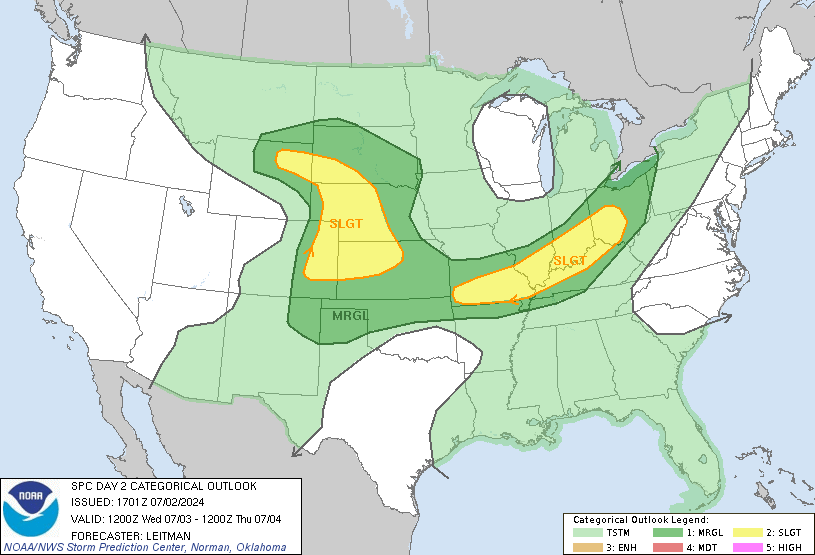
Good Monday evening gang. The potential for a major severe weather outbreak across our region is increasing for Tuesday into Tuesday night.
Another massive storm system will work out of the plains states into the northern Ohio Valley From Tuesday into early Wednesday. All the parameters are coming together for another wicked severe weather event in the warm sector of this storm. Tornadoes, damaging winds and large hail may be rather common starting Tuesday afternoon and lasting into Tuesday night.
Here is the latest outlook from the Storm Prediction Center…

This is a scary setup and will likely spawn hundreds of severe weather reports. The new analog map only adds to the cause for concern…
That is based off the NAM Model and shows the severe weather reports from 15 events the computer says matches tomorrow’s storm system.
Here is a breakdown of how this may play out…
– Scattered showers and storms will being to crank up tonight… especially across the northern half of the state.
– These storms will be around into the first half of Tuesday and will have a little better coverage. Some of these may be strong or severe.
– Skies should clear out late morning into Tuesday afternoon as temps soar into the 80s on a strong southwesterly wind.
– Thunderstorms will begin to develop across western Kentucky and roll eastward during the late afternoon and evening hours. Some of these storms may get out on their own and those will really be the ones to watch for possible tornadoes.
– This should transition toward a squall line racing eastward Tuesday evening and Tuesday night.
– Scattered storms would then continue into early Wednesday.
Given how the atmosphere is in supercharged mode this spring… please stay alert to the latest forecasts over the next few days. We will be here with updates as needed and will be tweeting updates as well.
Have a great evening and take care.
Select Page

Bobby Knight can burn in hell!!!
First!! Hope it doesn’t get too bad. Don’t want what happened over the weekend here.
Wow…the outlook seems a little scary. Thanks for keeping us updated. For anyone who would like to answer, hubby has to drive from Corbin to Owensboro Wednesday afternoon. Anyone know if the worst of the severe stuff will be past us by then?
He’s getting old, he’ll be there soon.
Finally have my videoblog up over on my site for those interested.
Read that MO,IL,IN may get upgraded to “High Risk” before all is said and done. Put the batteries in the weather radio and video camera. Going to be a wild ride tomorrow.
I thin a lot of areas will see high risk.
you r a joke.
please folks like this new weather channel on FACEBOOK and check out their website. they need all of our support
thanks
http://www.facebook.com/weathernation and check out their main website there 🙂
wow, totally uncalled for, asshole.
does anyone know the url for the website that provides the severe report analogs?
http://www.eas.slu.edu/CIPS/ANALOG/WARM/wwproducts.php?reg=DOM3&fhr=060&model=NAM212
That should get you in the vicinity.
Ignore trolls like this on here. Their main purpose is to cause trouble whereas your purpose is to be informative and I,for one, really appreciate all the input that you put out there.
Intresting… thank you
bicd q joeyj
kj new jersey school closings
appreciated info its gud to know…