Good Wednesday everyone. We have a heck of a warm period of weather to come over the next several days as the best of spring finally arrives. That doesn’t say much as our spring has been pretty nasty up until this point.
Before we look ahead… we must take a look back at the massive severe weather outbreak of Monday. This bad boy will go down as one of the most impressive severe weather events on record for the country. Here in Kentucky… we were in the middle of all the action with numerous wind damage reports. The folks at the various NWS offices have been busy surveying the damage across the state and have found 8 tornadoes so far. Here is a look…
I suspect we may add another twister or two to that map before all is said and done. Those were rated as 1’s and 2’s on the Enhanced Fujita Scale…
The overall number storm reports into the Storm Prediction Center from Monday is nothing short of amazing…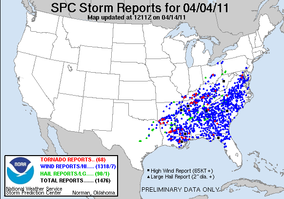
That is the most severe reports in a 24 hour period on record. The SPC no longer filters duplicate reports and that is adding to the overall number. Regardless… that is likely the most wind reports ever recorded in a day.
Where do we go from here?
Today will see much better weather rolling into town as partly sunny skies and temps in the 60s return. Some 70 degree temps will be possible in the west.
The warm air really surges in for Thursday as temps return to the 70s. It is once into Friday through the weekend that readings can really take off. Highs can hit 80 or better across much of the region. We will have to watch for some scattered storms during this time… especially across the north.
By late in the weekend into early next week… another huge low will begin to take shape across the plains states and head toward the western Great Lakes. This may become another big time severe weather producer that centers more on the midwest. We will have to keep an eye on how this plays out as it may send another squall line our way. Here is how the European Ensembles sees things…
That is likely to be a major wind maker once again. Speaking of… the warm temps of the next several days will be accompanied by gusty winds.
There you have it… some very nice spring days ahead of us. Have a great Wednesday and take care.
Select Page

Great job Monday with the storms. Now guess we will have to see what Friday and Sunday will have to offer. Dont forget to stop in and check out our facebook page Ohio Valley Weather Net
What day next week will the storms be most likely?
We are in Slight Risk on Friday of this week. Next week.. we are outlooked in the risk area for Sunday. It appears that next Thursday will bring severe weather also. So really, every few days we’re going to have a shot at some exciting weather. Enjoy it…because when July comes we won’t be able to buy a drop of rain.
Why are we still experiencing all this wind??!!!! Goodness!
Not always
I’ve noticed that sometimes we have VERY wet summers. And I don’t know why, but it always seems to be that the storms in the heart of HOT summer have MUCH more lightening
I am getting tired of all this wind!
A Red Flag Warning has been issued for much of the state.
I know! This makes all 6 days of April now that have seen wind gusts to 30MPH or higher.
Chris, thanks for posting that SPC data. I wonder why they stopped filtering out duplicates? From a stats perspective, I wonder how you’d have to parse the data now to get at the ballpark of the true number? At any rate, I’m sure going to miss all of this public info when SPC, NOAA, NWS and the like after their funding is likely eliminated in the forthcoming federal budget. I know you’re up to the challenge Chris, I just wish you didn’t have to worry about it.
High pressure over SE U.S. and low pressure over southern plains creating a tight pressure gradient thus increasing winds; kinda like a ‘wind tunnel’.
Don’t that just you blow you away??
Don’t know about you all…but I am getting tired of picking up tree limbs constantly…. ;-0. I do have a weather related question for those wishing to chime in….back when I was a kid….late 60’s early 70’s…I remember during the long, hot summer..there would be some nights where we would see what we called..”heat lightning”…don’t seem to see that weather phenomenon happen anymore…any ideas or thoughts….
Heat lightning doesn’t exist. Here….
http://www.farmersalmanac.com/weather/2009/08/03/what-is-heat-lightning/
saturday is a chance as well. as for july shouldn’t be a drought the la-nina is done for the summer season.
майл мини игры игры масяня и пляжные заморочки играть трейнер для age of mythology
Прохождение легенды 4. время пришло Картинки с ножками Car online games Читы для пв Нужно отдавать компас султану
Hello, guy! I am utterly acclaim your way of thinking and everything joined.
First of all, I would like to appreciate the choice of theme that you have chosen for your blog, it looks perfectly wonderful. Now, coming on today’s post I must say that you have explained the subject in a concise manner that makes it easily understandable. Thanks for this information.
ebmy my pxyqqu
vi unclaimed money in new jersey