Good Friday everyone. From flakes to floods… this is a wild weather pattern that is wrapping up on this Friday. River flooding is going to continue to be a huge deal over the next several days and we will get into that here in a bit.
Winter gave us a little slap in the face late Thursday with snow across much of central and eastern Kentucky. A slushy accumulation was noted and the light snow will wind down across eastern parts of the state early today. You can track the last flakes out of town here…
High temps today will range from the high 30s to low 40s in the east to the high 40s to low 50s in the west where more in the way of sunshine will be noted.
The weekend system is slowing down a bit and this will allow our Saturday to turn into a very nice day with highs well into the 50s with a 60 possible. Clouds will quickly increase Sunday with a few showers breaking out as a cold front swings in. This will knock temps down several degrees and there is a shot the showers end with a flake of snow by Sunday night.
A MUCH milder pattern is taking shape for the middle and end of next week and our temps should respond quite well. 70? 
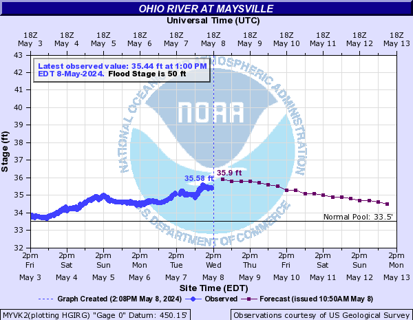
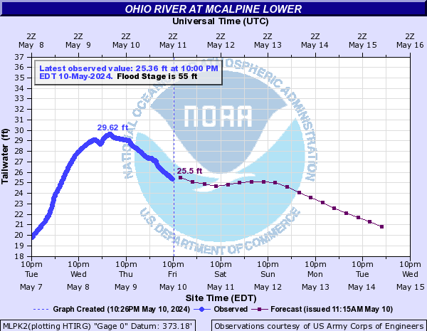
As we mentioned earlier… river flooding is going to continue to be a big issue for the next several days. The Ohio River will continue to see significant rises with moderate flooding likely at most locations.
Here is a look at the forecast for the river at various points…


Check out this graphic to see just how much rain has fallen over the past few weeks…
It’s amazing at how quickly mother nature can balance things out. The problem we face is possible going too far the other way as I foresee a VERY active severe weather season around here.
I will update things as needed so check back. Have a great Friday and take care.
Select Page

Oh how I suffered today outside at my Protest at the entrance of Sullivan College. It was windy, cold, rainy, then it started sleeting. I was trying to hold my umbrella and my signs. I guess Charlie Sheen isn’t all crazy. I should have planned better and brought gloves and a head covering.
8.8 earthquake in Japan, epicenter located entirely in the ocean. Tsunami warnings out for basically the entire Pacific ocean, including Hawaii and the west coast. Been watching the live feeds for the last couple hours, God, it’s just heartbreaking, devastation everywhere across the entire country. This is one of the strongest earthquakes ever recorded (6th). Predictions for initial tsunami wave heights have been drastically underestimated so far tonight. Please send out your thoughts and prayers.
Here’s the NOAA Propagation forecast for the resulting Tsunami.
http://i.imgur.com/9kW6o.jpg
Best live feeds for keeping up with what’s happening with the Japanese earthquake ->
http://www.bbc.co.uk/news/world-asia-pacific-12709598
http://www.youtube.com/aljazeeraenglish?feature=ticker
Livestreams for the U.S. west coast monitoring ->
http://producermatthew.com/post/3782260126/live-streams-west-coast-tsunami
Keep in mind, an earthquake this strong, and this shallow, has never hit such a dense population area.
If you have a friend or family in Japan, here’s the link for Google’s person finder for Japan – >
http://japan.person-finder.appspot.com/?lang=en
NOAA arrival time estimates for U.S. areas that are under tsunami watches or warnings – >
http://wcatwc.arh.noaa.gov/2011/03/11/lhvpd9/01/webetalhvpd9-01.txt
Please call people you know who might be affected along coastlines in those areas…especially heavy sleepers
USGS timeline for activity in the Asian region ->
http://earthquake.usgs.gov/earthquakes/recenteqsww/Maps/region/Asia_eqs.php
Live feed from Japan with English audio dub ->
http://jibtv.com/program/fullscreen.aspx?page=0
Video of a post-tsunami whirlpool in Uzumaki (much larger than you think)- >
http://www.youtube.com/watch?v=sU8zyscGWe4
Video on tsunami roaring across Japanese farmland and then towns ->
http://www.youtube.com/watch?v=e-A0NDsPcZY
One of the hardest hit cities is Kurihara (pop 70,000)
Live stream from Hawaii. First tsunami waves to hit about 8:06am EST
http://www.khon2.com/content/mediacenter/live.aspx?videoId=8928&navCatId=4
Thanks, Chris. I hope the flooding doesn’t get too bad. As for the spike in temps next week, as long as we dont’ get a hard freeze, that kills plants, I say YAY!!!! Just in time for Spring (and spring forward)
Right now I am glad I did not take that Job in Alaska.They are in the warning area too aren’t they??? Bless all the people who have lost loves ones or are in harm’s way.