Good Monday to one and all. We had a rather busy weekend across the state with widespread heavy rains and even accumulating snows for some. As we catch a break in the action over the next few days… we are already watching the next big storm due in town for the middle of the week.
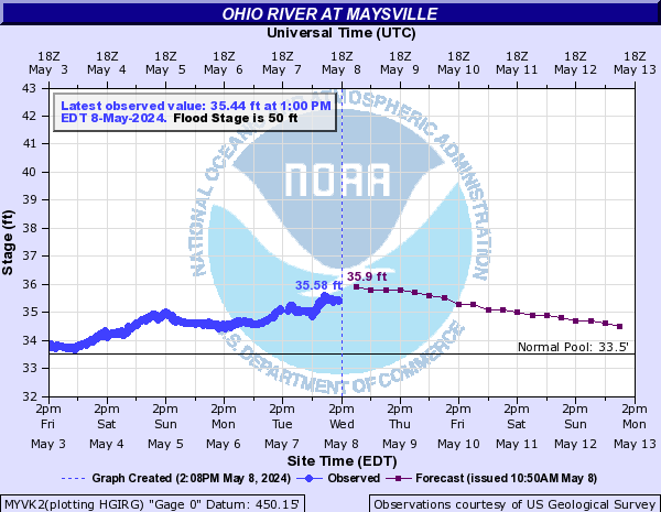
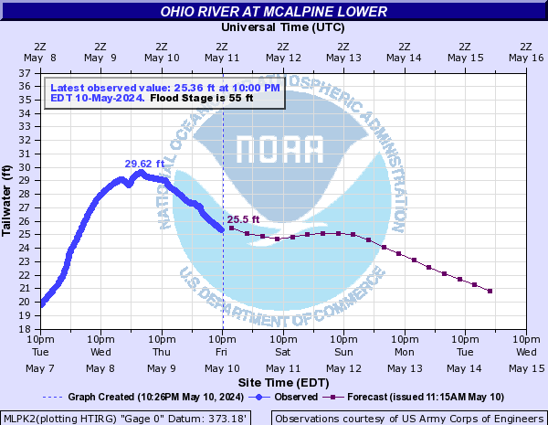
Before we get to the look ahead stuff… let’s review the river flooding situation across the state. Flood Warnings are now out for the following rivers…
– Ohio River at various points
– Kentucky River at Heidelberg and Ravenna
– Cumberland River at Williamsburg
– Green River at Rochester ,Woodbury, Paradise and Calhoun
Major rises are likely along the Ohio River over the next several days. Here is a look at the forecast for the river at various points…


Here is a breakdown of where we go from here…
– Partly sunny skies return today with temps ranging from the mid and upper 40s in the north and east to the low 50s west.
– Tuesday will see some late day clouds moving in ahead of our next storm. Temps will warm into the 50s for all.
– Low pressure will make a run into the Great Lakes Wednesday and drag a cold front into the region. Rain will increase from west to east Tuesday night into Wednesday. Locally heavy rains will again be likely and a few thunderstorms will be possible.
– An upper level low may try to “close off” across the Ohio and Tennessee Valleys late Wednesday into Thursday. This will try to spawn another low developing across the region with a renewed threat for heavy rainfall.
– Cold air will also try to filter into the closed low and this may lead to a change to some wet snow for some later Thursday.
I like what the European Model is doing with this setup…

I will have updates as needed so check back. Have a great Monday and take care.
Select Page

Thanks Chris Very interesting!!! I’m looking forward to the 50’s and a little sun! I’m STILL not excited about more heavy rain headed in here.
Never a dull moment around here.
Thanks chris for the update. We had another sugar coating of snow on the porches and cars this morning.
1-2″ of snow Thursday?
http://www.nco.ncep.noaa.gov/pmb/nwprod/analysis/namer//gfs/12/gfs_pcp072090_l.shtml
enough with the rain! Snow or Warm up and dry up a little. My vote for last chance of good snow is march 20th.
Update over on my blog if anyone is interested.
here we go again…de ja vu…FLOOD WATCHES POSTED FOR EAST KY…:(
Would like to see it dry up too,Got get them potatoes in the ground,plant some lettuce an onions,but it looks like another wet week..
Thanks, Chris. I know this is late, but we had computer issues at work today all day….I saw your tweet about the flash flood watch. when can we see a graphic of that? Just curious as to who it covers….have a good night all.
Hello, guy! I am completely acclaim that way of thinking and everything connected.
You seems to be an expert in this field, good post and keep up the great work, my friend recommended me this.
My blog:
Meilleur Taux aussi au Rachat de Credit