Good Tuesday, everyone. It’s a super-soaker of a pattern that rolls through the next few days, bringing the potential for local high water issues. Later this week, we have the potential for some winter weather and even some light accumulations of snow.
Rounds of heavy rain continue today and we may even hear some rumbles of thunder. Given the setup, flash flooding issues are possible. That’s especially the case with additional waves of heavy rain through Wednesday and early Thursday.
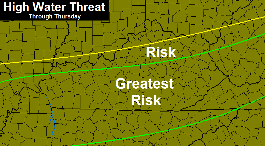
My thoughts on the areas of greatest high water concerns remain the same…
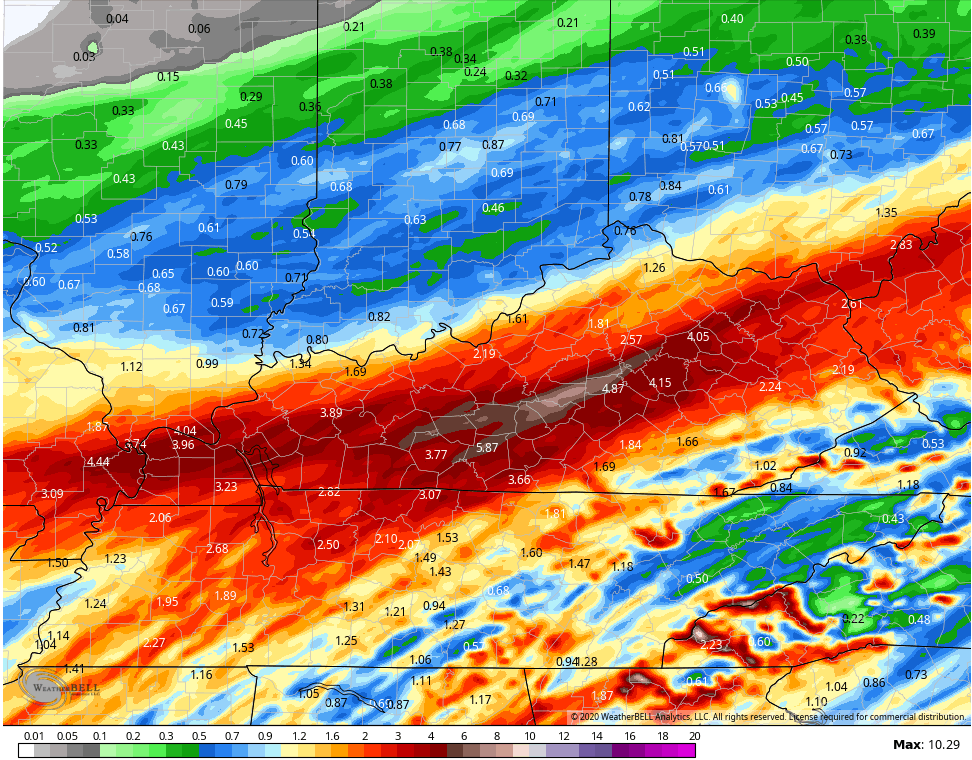
 A general 1`”-4″ of rain is likely across the region, with locally higher amounts possible. That’s especially the case if a few thunderstorms get into the mix.
The Hi Res NAM is going crazy with some of the rain numbers through Wednesday night…
 The GFS shows amounts around 5″…
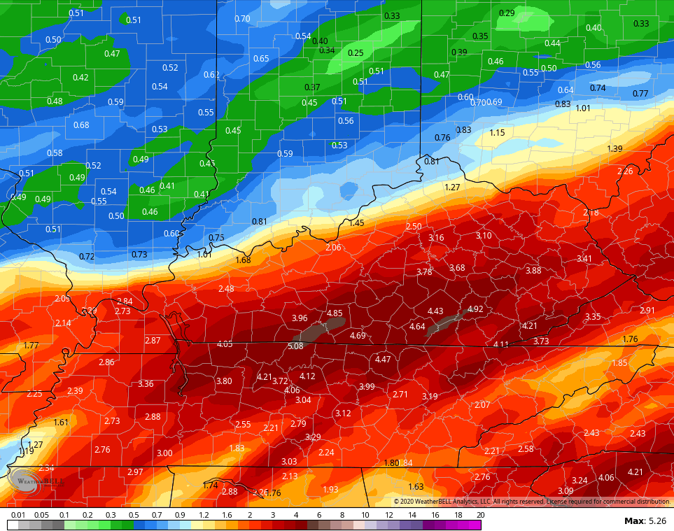 The ICON has some similar totals…
![]()
![]()
High water issues may become an issue later today and into Wednesday. If you live in a low-lying area, keep a close eye on water levels.
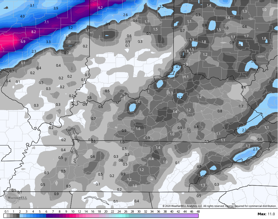
By later Thursday, temps crash and we will get in on rounds of light snow that takes us into Friday. The NAM shows this into Friday morning…
 You can also see a touch of freezing rain trying to show up in the north on Wednesday.
Here’s the light snow accumulation from the NAM…
 The next system then takes a southern track on Saturday and could bring a swath of snow into parts of the state. The European Model is pretty amped up in the east…
 I will have updates later today. Until then, I have you all hooked up to track today’s soaking…


Have a great one and take care.

Chugga, Chugga, Chugga Choo! Choo! All aboard with free tickets for the annual February KY RainTrain. Destination is from the TN to the Ohio Valley. Warning disclaimer: We are not responsible for any flooded tracks, mudslides or any other obstructions that may pose danger to your safe travels!
I’m getting on the westbound to Oklahoma. My aunt & uncle out there are under WSW now for up to 4-6″+ snow near the Tulsa area, but even their met says on his blog that their last few winters haven’t been that predictable even as close as a couple hours before the precip begins because they don’t know where the exact track will go. Well, at least I have 2 options to live vicariously through it:watch their local news/wx on roku, or, call my 92 y/o aunt who will tell me they haven’t had any snow for the past several yrs., while my uncle who is a little younger verifies they have about 9″ on the ground. LOL!
LOL….SEND SOME BACK PLEASE! BE SAFE 🙂
Looking forward to the largest snowfall of the season for the Chicago area on Wednesday night/Thursday morning, as the NWS believes it will be a “plowable” snow. How that translates into inches we’ll see.
We set a new record high on Sunday, with a high of 52 degrees at O’Hare (old record was 51) and 53 at the NWS in Romeoville in the SW suburbs. Even Monday was a much-above normal day, with a high of 49 degrees. Colder weather is on the way, though. Normal highs here for early February are around 32 degrees.
You guys in Kentucky are really getting soaked this morning! Looking at the radar at 3:30 AM, most of Kentucky except for the far north is receiving a steady rain.
Two Februarys straight in Harlan, I have recorded over a foot of rain! Will this be #3? Chances are high for that possibility.
FEB 2018: 12.24 in
FEB 2019: 12.83 in
Average: 4 inches
When one thinks about it, this excessive rainfall is amazing really. To triple an average amount two years consecutively is one thing, but if I do it three straight years for the same calendar month will be quite amazing.
I hope you get some snow this week 🙂
I think February will at least be average for you but that is just my guess based upon current pattern. I hope you overachieve!
We are overdue; incredibly, our largest snowfall this season was the two inches we got the day before Halloween! That wasn’t a shovelable snow though, as it stuck on the gra*s*s*y areas, and just a little on the pavement.
The NWS office in Romeoville in the SW suburbs has recorded just 8.5 inches of snow since Dec. 1st, and 12.0 inches for the season. O’Hare Airport is around 18 inches.
Just 10 days ago, the NWS predicted a solid 3 to 5 inches of snow for our area, with most computer models (except for the GFS) predicting at least 5 to 6 inches or more, but that really fizzled with the temps being so marginal, making the snow go back and forth to a mix. As a result, just a half-inch or so of snow fell.
Those are incredible rain numbers for you the past two Februarys for sure!
This pattern has got to break sooner or later. It has been strange it keeps repeating the same track cold air is just west of us and the warm air has built a dome over our state of ky
Will be interesting of what happens. Betting thre mets don’t know either.
Snowfall for my county of Taylor remains at 2.0 inches, which fell on November 12, 2019. Looking at a lot of weather maps and even the extended, which ( I don’t put much stock in ) my hopes for any major snowstorms in my area of Kentucky are beginning to dwindle. I still hold a glimmer of hope that we will have a pattern change sometime before March first ? If not, I will have to conclude that major snowstorms in my area of Kentucky are going to go from rare events to nonevents.
Pattern will persist until the Warm waters off of the coast of Alaska, well, stop being off the coast of Alaska, been like this since Fall 2012.
Looks like NAM has come around to agreeing with GFS (and Euro) about the Wed-Thurs storm. All three now have the nasty dark pink stuff staying mostly north of the Ohio river. Hopefully we don’t see that line drift southward.
GFS has been pretty accurate this winter.
Really too warm to consider ice. Looks like an above freezing at best switch to wet snow, if anyone licks up.
It use to be like this folks, if there was a snowstorm in the Texas and Oklahoma area, that snowstorm would be in Southern Indiana and Kentucky within two days. The upper levels of the atmosphere have really changed and no one can really explain why this is. Oh, you can blame it on the Southeast Ridge or the Eastern Pacific flow, But, what is causing that ? It might be what is going on with the Sun. The other day Winter Lover brought this up about the Sun having fewer Sunspots might be causing this awful weather pattern to persist. So I took the liberty of looking that theory up and found out that the Sun has just entered Cycle number 25. What does that mean ? Does any scientist out there really know ? When I was in college back in 1971 my Climatology Professor, said ” first study astronomy, followed by climatology, and lastly, study meteorology and then you will be more confused. ” I don’t know but I am running out of weather comments.