Good Sunday, everyone. After a few days of winter weather broke up the heavy rain pattern, it’s ready to return for the week ahead. Several inches of rain are likely this week and we should see, unfortunately, more flooding problems. This is a very ugly setup for much of the region.
As you know, areas of southeastern Kentucky have been devastated by flooding in rent days.The Cumberland River almost broke the record for highest levels in Pineville and Williamsburg, and hit the top 10 for Barbourville.
Flood Warnings are still out for the Cumberland and a few other rivers…

The first round of rain moves in tonight and Monday, so I suspect Flood Watches go up today…

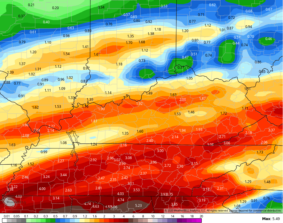
The NAM rainfall map goes through 7am Wednesday and is ugly…
 Waves of low pressure work through the region for the rest of the week, bringing more heavy rains…
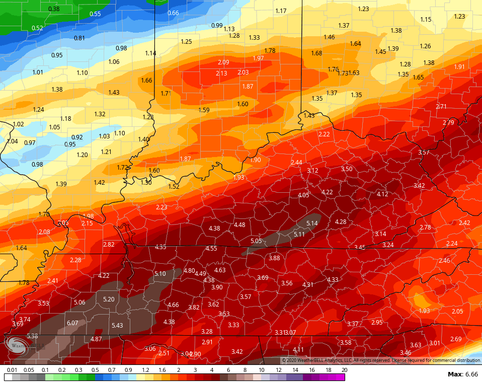
  The GFS rainfall map through Thursday night is scary…
 The Canadian is similar, but has more of a wintry end to it all…
 Here are the rain numbers from the Canadian…
 The EURO isn’t quite as hefty as the other two models, but still shows some big time rains…
 I will have updates later today. Until then, here are your radars to get things started…

Have a great Sunday and take care.

Yesterday (Saturday) morning, about three inches snow fell at my parents’ place between Chattanooga and Cleveland TN. Not too surprisingly, the higher elevations along the TN-NC border and into north Georgia got even more. Granted, a rapid afternoon warmup saw the snow cover being short lived. Still, kind of crazy considering that places farther north had not seen even an inch.
If these totals are realized in SEKY, there are going to be some seriously terrible flooding. If these totals are shown once again I would think a state of emergency would be declared. along with possible evacs, and other emergency management issues. Just my thoughts on the possibility of flooding, every drop of rain will be runoff that’s called flooding. “Rant Over”
It looks like S.E. KY. is the rain capital of the USA.
Rainuary has arrived. Double digit rain totals for the last three years for a month that only averages something like four inches. I can’t wait until this non-winter is officially out of here and spring can settle in. It could get ugly once again for here in the corner of the state.
This is nothing but bad news for my home area my friends, no question about it. A state of emergency was already declared in McDowell County, WV Thursday. I don’t know about any southeastern KY counties, but I do know for a fact one was issued for us. I would prefer heavy snow over heavy flooding, any day.
*Roll eyes emoji*
When I predicted a possible 3rd straight February in Harlan with a foot of rain, I was serious but did I go too low on the monthly total? Geeze. I may be near a foot by next weekend with half of the month to go.
We just can’t get out of this pattern. A bunch of people were panicking over a dry September (you should have dry periods), but I kept saying the rain will return and it has. I looked back at 2018 data about this time last year and we had like 20 more rain days than what Buffalo NY averages and they are considered to annually have the most in the U S. It literally rains like every other day in Kentucky. When I was growing up I can remember going weeks in the summer without rain, but those days are long gone.
I disagree with the summer comment about going weeks without rain. You just said yourself that people were complaining about the month of September being dry. Some didn’t see any measurable rainfall for 4 to 5 weeks. That’s going weeks without any rain for some. Matter of fact it was record breaking Louisville’s driest September ever recorded 0.04 rain fell for the entire month. The only way to achieve that record is to have weeks with no rain. Last year was wet no doubt but do not overlook from mid to late July last year until mid October the rain just shut off pretty abruptly for most. Like I said some went many weeks without rain. So those days are not long gone it literally just occurred last summer.
2018 was the year I looked at.
It was nice to get a small stretch with no rain last year. That was the first time in a while that we had a stretch like that. The faucet has turned back on now.
I agree the clouds and rain has wore out its welcome it’s a bit excessive to say the very least.
This seems to be the winter of the occasional 1 to maybe 2 inch snows in the Chicago area, we just can’t get a major snowstorm. It’s currently snowing in my area, and may accumulate around an inch, but it’s going to quickly melt and change to rain as the temps go several degrees above freezing this afternoon.
An inch here, an inch-and-a half there… doesn’t make for a very exciting winter. We’re currently at 14.5 inches for the season in the SW suburbs.
Meantime, I’ll be following the heavy rain event for SE Kentucky this week, and hope that you guys can stay safe from any major flooding.
Totally low snowfall out your way for sure. I have enjoyed your input and observations, Illinois Mike. Please keep it coming 🙂