Good afternoon, everyone. Rounds of heavy rain continue to roll across the region and this is a sign of things to come. Additional heavy rain and strong storms will be noted through the middle of the week as a potent system moves in. All of this leads to an increased flooding risk.
A Flood Watch is out for only a few counties in the far southeastern part of the state..

I get that those were the counties hardest hit, but come on guys. Expand that thing to include much more of this region. Geez.
This may need to be expanded much farther north for Tuesday and Wednesday as the next wave of heavy rain moves across much of the region. That’s especially true since some areas have already picked up well more than 1″ of rain through noon today…
 The next round of heavier rain arrives tonight and early Tuesday before a bit of a break in the action. That window closes quickly with heavy rain and strong storms arriving Wednesday. Colder winds blow for Thursday with some flakes flying…
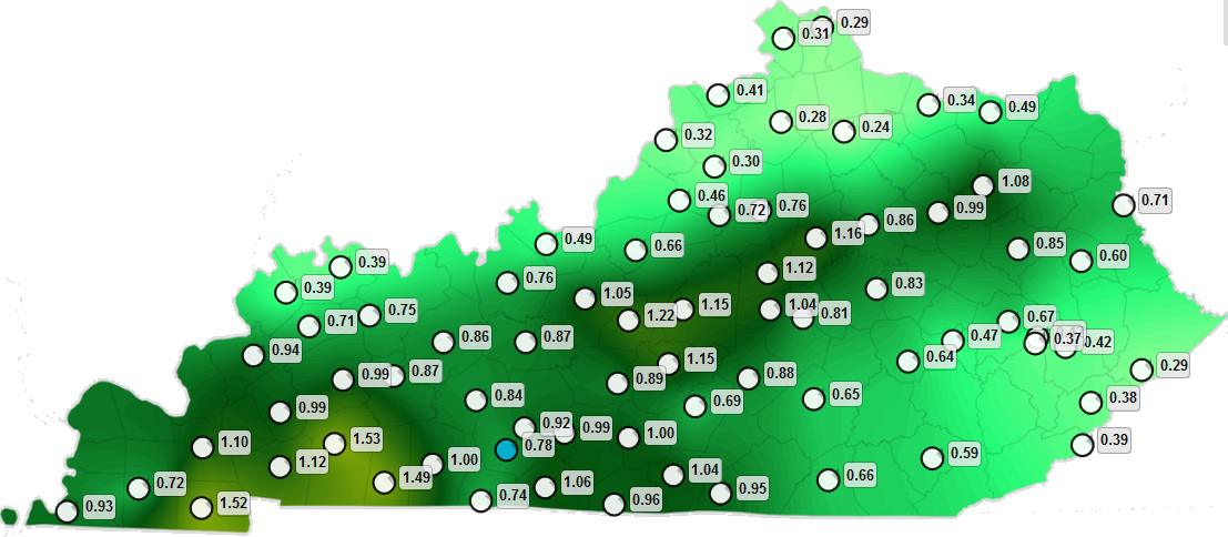
 The Flood Threat map remains the same during this time…

The severe risk for Wednesday afternoon and evening is there, especially across parts of southern Kentucky. Here’s the outlook from the Storm Prediction Center…

The setup from this weekend through next week continues the active pattern with more rounds of heavy rain…
 I will have the latest on WKYT-TV starting at 4pm and then again on KWC this evening. I leave you with your tracking toys…


Enjoy the afternoon and take care.

All this moisture and no cold air… sigh We could have had so much snow
This is not getting any better. The water didnt even get a chance to get back in it’s banks and it is pouring again. Rainuary may set records this month. Can’t wait until March 8 and DST. The winter that never started is creating at lot of water views for homes that never had them .
I bet the upcoming winter of 2020 & 2021 will be the exact same carbon copy of this winter.
Why because the 2020 weather so far this year looks like a repeat copy of 2019.
Maybe even a little warmer than 2019. We did have the frigid three day much hyped “Polar Vortex (formerly called winter) that came in Jan. 2019. We didn’t even flirt with a single digit morning this year.
Definitely warmer than 2019, so far and only a few weeks to go. We are between top 5 and top 10 statewide at most NWS locations in running with years like 2012!
Ugh!!! Come, cold air! So much moisture, and not cold enough. It’s winter. Colder air and this would be a fabulous snow! Still expecting snow. We did get ten inches in March a while back.
Unfortunately, the next 8 – 14 days temps are forecast to be above normal.
Which is cool with me because there is no data to support a decent snowfall anyway.
I just like to see some sunny dry days.
RIP winter….raintrain on steroids
Winter is coming folks, Just wait!! I am all about #teamspring, but what is in store for us late Feb thru March is gonna be true winter. Things are going to flip and this pattern will change. Until then everyone needs to prepare for some major flooding as what is in store for the next couple weeks is going to be nothing less than devastating SE Ky down through TN. Nashville may be underwater in a couple weeks.
I disagree, The real winter is about over, Yeah we will see a couple of days that are marginaly cold but for the most part temps will be 5 to 10 degrees above normal, with ALOT of rain!
AccuWeather (computer models) is forecasting three day time highs below 50 in the next three weeks. Those temps are 35 (this Friday and dry), 48,49. If real winter is going to come in February then the computer models are not seeing it yet. We might get a good snow in March, but it’s a good chance that it won’t have any staying power. Temps go above the 50 degree point for average day time highs in the southern part of the state this week. Like it or not spring is near. Less than three weeks of Meteorological winter left. 2019-2020 the winter that never started.
The cold is up at the caps and freezing everything up. Natural cycle every 30 to 50 years. You probably won’t see any current ice cap melting “news” from the national media for a while. They’re probably working on another spin…. Not sure I’m joking there.
LOL. I hope some ice up there helps cool things down here a little in the upcoming years.
They sure will. Then when they spin the new spin, they’ll tell you they never said what was said before, creating internet articles with pictures and everything else to try and brainwash you into their line of thinking.
It’s so insane.
So far, I have only had light to moderate rainfsll here @ 0.77 in for the new event thtough 5PM and a bit soggy with some waterfalls but nothing bad YET.
So, the race to a foot of rain is on. I am neck and neck with other SE KY counties and currently sitting at 6.57 in month-to-date. I believe we legitimately set a record wettest month ever for some of us as the data is there to go way over a foot!
1.06 for me thus far Terry
0.91 in South Williamson
I understand CB’s concerns about expansion of Flood Watches. However, there are at least two distinct waves that will affect the region. The first Watch actually goes till Tuesday morning for those few southeastern counties when the first wave(s) should eventually cease. River levels are behaving there for now.
But, the next wave expected Wednesday looks to have more oomph. Where the axis of heaviest rainfall is still in question. But, the Kentucky River near Ravenna in Estill county is expected to head toward flood stage later this week. So, the expansion of Flood Watches are coming. Just cannot issue a week long flood watch. Nobody will get any sleep then.
Still raining fairly hard here. And no flood watch or warning that I can find. Even the NWS in Jackson does not have one listed for us.
The river in town is way up already.
The stream by my house is running across the road now. And the bigger stream these smaller ones run into is across the road. Son is at work and might not be getting home tonight.
On top of that it is getting extremely foggy.